TopoQuest Logo
Do you find TopoQuest useful?
Help keep TopoQuest running and adding new maps/features by donating!
Bitcoin:  19c7KJd3qBynnjoSw5npx9KScwjBe4ifkT
Litecoin:  LXs6TkuXGGXo1vDsWCkWVdjQX94eUKd6ui
Home View Maps Find Maps Find Places Resources & Links


China Grove, Alabama Topographic Map

USGS Map Title: China Grove, AL
USGS Map MRC: 32085A8
DRG (GeoTIFF) Download: o32085a8.tif


Neighboring USGS Topographic Map Quads:


  Teasleys Mill, AL  
32086B1
 

  Fitzpatrick, AL  
32085B8
 

  Thompson, AL  
32085B7
 

  Pine Level, AL  
32086A1
 

  China Grove, AL  
32085A8
 

  Almeria, AL  
32085A7
 

  Ansley, AL  
31086H1
 

  Needmore, AL  
31085H8
 

  Saco, AL  
31085H7


Map MRC Location:

N33°
W86°
N33°
W85°
H8 H7 H6 H5 H4 H3 H2 H1
G8 G7 G6 G5 G4 G3 G2 G1
F8 F7 F6 F5 F4 F3 F2 F1
E8 E7 E6 E5 E4 E3 E2 E1
D8 D7 D6 D5 D4 D3 D2 D1
C8 C7 C6 C5 C4 C3 C2 C1
B8 B7 B6 B5 B4 B3 B2 B1
A8 A7 A6 A5 A4 A3 A2 A1
N32°
W86°
N32°
W85°

China Grove, AL USGS 1:24K Topographic Map Preview:
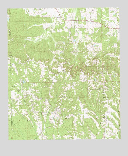
China Grove, AL USGS Topographic Map
Click on map above to begin viewing in our Map Viewer.

This topographic map contains these locations and features:
Feature Name Type Latitude Longitude GNIS ID View Map
Bear LakeReservoirN32.0551°W85.9822°130089View Map
Bear Pond DamDamN32.0552°W85.9816°130090View Map
Bethesda CemeteryCemeteryN32.0793°W85.9991°114100View Map
Bristol Store (historical)LocaleN32.0757°W85.9747°135200View Map
C E Sellers Number 2 DamDamN32.1151°W86.0000°130152View Map
China GrovePopulated PlaceN32.0296°W85.9447°164039View Map
China Grove CemeteryCemeteryN32.0265°W85.9491°163514View Map
China Grove CreekStreamN32.0102°W85.9597°116057View Map
Concord ChurchChurchN32.0260°W85.9491°163516View Map
Concord ChurchChurchN32.0235°W85.9483°163238View Map
Dennis CemeteryCemeteryN32.0054°W85.9158°163519View Map
Dicky CreekStreamN32.0088°W85.9694°117278View Map
Edwards CemeteryCemeteryN32.0746°W85.9791°135215View Map
Friendship ChurchChurchN32.0199°W85.9333°118677View Map
HectorPopulated PlaceN32.1124°W85.9088°156464View Map
Hector Elementary School (historical)SchoolN32.1204°W85.9063°154388View Map
High RidgePopulated PlaceN32.0627°W85.8950°155098View Map
Hopewell ChurchChurchN32.1185°W85.9408°135229View Map
McGowanPopulated PlaceN32.0690°W85.9402°135236View Map
McInnus School (historical)SchoolN32.0618°W85.9225°135237View Map
Mount Carmel Baptist ChurchChurchN32.1054°W85.8866°155887View Map
Mount Carmel CemeteryCemeteryN32.1051°W85.8852°1805463View Map
Mount Olive ChurchChurchN32.0726°W85.9811°123294View Map
Mount Zion ChurchChurchN32.0199°W85.9344°164087View Map
New Hope ChurchChurchN32.0635°W85.9813°135256View Map
Old Union ChurchChurchN32.0629°W85.9441°124268View Map
Pickett CemeteryCemeteryN32.1138°W85.9302°135262View Map
Picketts Gin (historical)LocaleN32.0918°W85.9238°135263View Map
Pleasant Grove ChurchChurchN32.0396°W85.8900°124952View Map
Salem ChurchChurchN32.0618°W85.9800°126240View Map
Sellers Lake Number TwoReservoirN32.1149°W85.9991°130153View Map
ShoptonPopulated PlaceN32.1171°W85.9422°126805View Map
Warriorville Post Office (historical)Post OfficeN32.0235°W85.9158°139850View Map

Note: Coordinates in the location and feature list above are referenced to NAD83 datum.


Copyright (C) 2008-2025 Ryan Niemi / Sunset Dynamics ... All Rights Reserved