TopoQuest Logo
Do you find TopoQuest useful?
Help keep TopoQuest running and adding new maps/features by donating!
Bitcoin:  19c7KJd3qBynnjoSw5npx9KScwjBe4ifkT
Litecoin:  LXs6TkuXGGXo1vDsWCkWVdjQX94eUKd6ui
Home View Maps Find Maps Find Places Resources & Links


Pittsfield, Illinois Topographic Map

USGS Map Title: Pittsfield, IL
USGS Map MRC: 39090E7
DRG (GeoTIFF) Download: o39090e7.tif


Neighboring USGS Topographic Map Quads:


  Baylis, IL  
39090F8
 

  New Salem, IL  
39090F7
 

  Griggsville, IL  
39090F6
 

  Summer Hill, IL  
39090E8
 

  Pittsfield, IL  
39090E7
 

  Milton, IL  
39090E6
 

  Pleasant Hill West, IL  
39090D8
 

  Pleasant Hill East, IL  
39090D7
 

  Pearl West, IL  
39090D6


Map MRC Location:

N40°
W91°
N40°
W90°
H8 H7 H6 H5 H4 H3 H2 H1
G8 G7 G6 G5 G4 G3 G2 G1
F8 F7 F6 F5 F4 F3 F2 F1
E8 E7 E6 E5 E4 E3 E2 E1
D8 D7 D6 D5 D4 D3 D2 D1
C8 C7 C6 C5 C4 C3 C2 C1
B8 B7 B6 B5 B4 B3 B2 B1
A8 A7 A6 A5 A4 A3 A2 A1
N39°
W91°
N39°
W90°

Pittsfield, IL USGS 1:24K Topographic Map Preview:
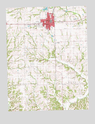
Pittsfield, IL USGS Topographic Map
Click on map above to begin viewing in our Map Viewer.

This topographic map contains these locations and features:
Feature Name Type Latitude Longitude GNIS ID View Map
Barnd CemeteryCemeteryN39.5056°W90.8393°1725358View Map
Burbridge CemeteryCemeteryN39.5195°W90.8140°1725368View Map
Calvary Baptist ChurchChurchN39.6062°W90.8135°1822210View Map
Church of ChristChurchN39.6037°W90.8082°1822211View Map
City of PittsfieldCivilN39.6055°W90.8064°2396217View Map
Daniels CemeteryCemeteryN39.5303°W90.7698°1725376View Map
Fairview School (historical)SchoolN39.5975°W90.8474°408208View Map
First Baptist ChurchChurchN39.6064°W90.8074°1822212View Map
First Christian ChurchChurchN39.6089°W90.8079°1822213View Map
George W Schuster Airport (historical)AirportN39.5995°W90.8312°427685View Map
Goodin CemeteryCemeteryN39.5598°W90.8257°1725385View Map
Gray CemeteryCemeteryN39.5053°W90.8337°1725387View Map
Higbee Junior High SchoolSchoolN39.6087°W90.8104°1725393View Map
Highlands School (historical)SchoolN39.5528°W90.8287°410239View Map
Honey Creek School (historical)SchoolN39.5242°W90.7632°410480View Map
Illini Community HospitalHospitalN39.6075°W90.8150°1725399View Map
Illini Community Hospital HeliportAirportN39.6073°W90.8140°427687View Map
IndependencePopulated PlaceN39.5314°W90.7915°422835View Map
Johnson CemeteryCemeteryN39.5181°W90.7604°1725402View Map
Kent CemeteryCemeteryN39.5525°W90.7557°1725403View Map
King ParkParkN39.6153°W90.8071°1725405View Map
Liberty School (historical)SchoolN39.5534°W90.8479°412021View Map
Lowder CemeteryCemeteryN39.5503°W90.8343°1725408View Map
Lowry ParkParkN39.6020°W90.8149°1725409View Map
MartinsburgPopulated PlaceN39.5159°W90.8426°422946View Map
Oakwood CemeteryCemeteryN39.5937°W90.8104°1725421View Map
Old Orchard Country ClubLocaleN39.6106°W90.7685°1725423View Map
Petty CemeteryCemeteryN39.5595°W90.8098°1725427View Map
Pike County Infirmary (historical)LocaleN39.5834°W90.8287°1725429View Map
Pike County Sheriff's OfficeBuildingN39.6074°W90.8053°2759078View Map
Pine LakeReservoirN39.6223°W90.8136°1691891View Map
Pine Lake DamDamN39.6234°W90.8101°1691890View Map
PittsfieldPopulated PlaceN39.6078°W90.8051°415748View Map
Pittsfield City Fire DepartmentBuildingN39.6088°W90.8055°2640659View Map
Pittsfield East Elementary SchoolSchoolN39.6098°W90.8010°1822220View Map
Pittsfield High SchoolSchoolN39.6000°W90.8046°1725431View Map
Pittsfield Historic DistrictParkN39.6056°W90.8060°1822221View Map
Pittsfield Police DepartmentBuildingN39.6086°W90.8048°2758906View Map
Pittsfield Post OfficePost OfficeN39.6058°W90.8065°1725432View Map
Pittsfield South Elementary SchoolSchoolN39.5992°W90.8101°1822222View Map
Pittsfield West CemeteryCemeteryN39.6070°W90.8235°1725433View Map
Pleasant Grove School (historical)SchoolN39.5578°W90.7718°415805View Map
Prairie School (historical)SchoolN39.5898°W90.7510°416159View Map
Rose Hill School (historical)SchoolN39.5206°W90.8154°416947View Map
Saint Marys Catholic ChurchChurchN39.6081°W90.8032°1822225View Map
Sunny HillPopulated PlaceN39.6231°W90.7710°423220View Map
Sunny Hill CemeteryCemeteryN39.6234°W90.7710°1852496View Map
Tamsett CemeteryCemeteryN39.5864°W90.8379°1725458View Map
Township of MartinsburgCivilN39.5319°W90.8586°429332View Map
Township of PittsfieldCivilN39.6200°W90.8585°429572View Map
Waggoner CemeteryCemeteryN39.5428°W90.8393°1725466View Map
Watson CemeteryCemeteryN39.5531°W90.7968°1725468View Map
WBBA-AM (Pittsfield)TowerN39.5814°W90.7979°428067View Map
WBBA-FM (Pittsfield)TowerN39.5814°W90.7979°428274View Map

Note: Coordinates in the location and feature list above are referenced to NAD83 datum.


Copyright (C) 2008-2024 Ryan Niemi / Sunset Dynamics ... All Rights Reserved