TopoQuest Logo
Do you find TopoQuest useful?
Help keep TopoQuest running and adding new maps/features by donating!
Bitcoin:  19c7KJd3qBynnjoSw5npx9KScwjBe4ifkT
Litecoin:  LXs6TkuXGGXo1vDsWCkWVdjQX94eUKd6ui
Home View Maps Find Maps Find Places Resources & Links


Plainview, Illinois Topographic Map

USGS Map Title: Plainview, IL
USGS Map MRC: 39089B8
DRG (GeoTIFF) Download: o39089b8.tif


Neighboring USGS Topographic Map Quads:


  Hettick, IL  
39090C1
 

  Carlinville West, IL  
39089C8
 

  Carlinville East, IL  
39089C7
 

  Summerville, IL  
39090B1
 

  Plainview, IL  
39089B8
 

  Gillespie North, IL  
39089B7
 

  Shipman, IL  
39090A1
 

  Bunker Hill, IL  
39089A8
 

  Gillespie South, IL  
39089A7


Map MRC Location:

N40°
W90°
N40°
W89°
H8 H7 H6 H5 H4 H3 H2 H1
G8 G7 G6 G5 G4 G3 G2 G1
F8 F7 F6 F5 F4 F3 F2 F1
E8 E7 E6 E5 E4 E3 E2 E1
D8 D7 D6 D5 D4 D3 D2 D1
C8 C7 C6 C5 C4 C3 C2 C1
B8 B7 B6 B5 B4 B3 B2 B1
A8 A7 A6 A5 A4 A3 A2 A1
N39°
W90°
N39°
W89°

Plainview, IL USGS 1:24K Topographic Map Preview:
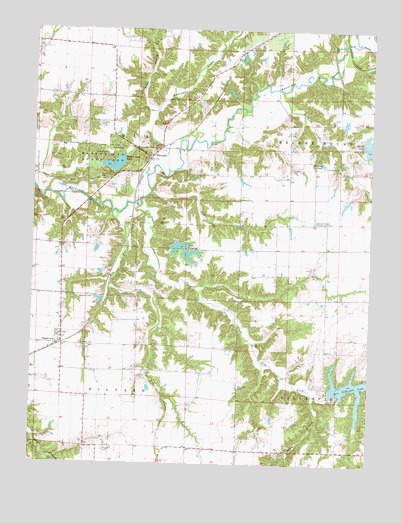
Plainview, IL USGS Topographic Map
Click on map above to begin viewing in our Map Viewer.

This topographic map contains these locations and features:
Feature Name Type Latitude Longitude GNIS ID View Map
Adams BranchStreamN39.1453°W89.8959°403344View Map
Beaver Dam LakeReservoirN39.2112°W89.9701°404059View Map
Beaver Dam State ParkParkN39.2112°W89.9762°404060View Map
Beaver Lake DamDamN39.2100°W89.9751°1691942View Map
Brayford CemeteryCemeteryN39.2075°W89.9762°404806View Map
Broom OrchardLocaleN39.2481°W89.9086°2681044View Map
Combes CemeteryCemeteryN39.1592°W89.9820°406422View Map
Denby Prairie Nature PreserveParkN39.2414°W89.9265°2009792View Map
Dorman School (historical)SchoolN39.1798°W89.9620°1764606View Map
Dry ForkStreamN39.1989°W89.9615°407419View Map
East Liberty School (historical)SchoolN39.1900°W89.9379°1764611View Map
Emerick CemeteryCemeteryN39.2456°W89.8906°407989View Map
Hacke CemeteryCemeteryN39.2098°W89.9051°409591View Map
Hillyard CemeteryCemeteryN39.1295°W89.9718°410302View Map
Honey CreekStreamN39.2464°W89.8804°410474View Map
Hurricane CreekStreamN39.2095°W89.9504°410717View Map
Kent BranchStreamN39.2262°W89.9554°411410View Map
Lake CatatogaReservoirN39.1866°W89.9443°405695View Map
Lake Catatoga DamDamN39.1887°W89.9473°1691379View Map
Lick BranchStreamN39.2031°W89.9568°412041View Map
MacoupinPopulated PlaceN39.2134°W89.9573°422929View Map
May BranchStreamN39.1973°W89.9712°413150View Map
Morrison CemeteryCemeteryN39.1473°W89.9234°413845View Map
New Gillespie LakeReservoirN39.1473°W89.8791°414396View Map
New Gillespie Lake DamDamN39.1439°W89.8882°1691946View Map
Oak Hill School (historical)SchoolN39.2434°W89.9054°1764674View Map
PlainviewPopulated PlaceN39.1592°W89.9898°415754View Map
Plainview Post OfficePost OfficeN39.1592°W89.9907°1821352View Map
Pleasant Grove School (historical)SchoolN39.1517°W89.9415°1764680View Map
Smith Reservoir DamDamN39.2184°W89.8784°1691944View Map
Snedeker Grove School (historical)SchoolN39.1298°W89.9787°1764703View Map
Spanish Needle Community CenterBuildingN39.1945°W89.8959°418874View Map
Spanish Needle CreekStreamN39.2323°W89.9093°418875View Map
Spanish Needle School (historical)SchoolN39.1973°W89.8943°1764706View Map
Suhling PondReservoirN39.2117°W89.8933°419325View Map
Township of HillyardCivilN39.1300°W89.9794°429137View Map
Township of PolkCivilN39.2170°W89.9801°429586View Map
Waggoner CemeteryCemeteryN39.1728°W89.9832°420373View Map

Note: Coordinates in the location and feature list above are referenced to NAD83 datum.


Copyright (C) 2008-2025 Ryan Niemi / Sunset Dynamics ... All Rights Reserved