TopoQuest Logo
Do you find TopoQuest useful?
Help keep TopoQuest running and adding new maps/features by donating!
Bitcoin:  19c7KJd3qBynnjoSw5npx9KScwjBe4ifkT
Litecoin:  LXs6TkuXGGXo1vDsWCkWVdjQX94eUKd6ui
Home View Maps Find Maps Find Places Resources & Links


Pleasant Dale Valley, Illinois Topographic Map

USGS Map Title: Pleasant Dale Valley, IL
USGS Map MRC: 39090C6
DRG (GeoTIFF) Download: o39090c6.tif


Neighboring USGS Topographic Map Quads:


  Pleasant Hill East, IL  
39090D7
 

  Pearl West, IL  
39090D6
 

  Pearl East, IL  
39090D5
 

  Annada, MO  
39090C7
 

  Pleasant Dale Valley, IL  
39090C6
 

  Kampsville, IL  
39090C5
 

  Elsberry, MO  
39090B7
 

  Hamburg, IL  
39090B6
 

  Hardin, IL  
39090B5


Map MRC Location:

N40°
W91°
N40°
W90°
H8 H7 H6 H5 H4 H3 H2 H1
G8 G7 G6 G5 G4 G3 G2 G1
F8 F7 F6 F5 F4 F3 F2 F1
E8 E7 E6 E5 E4 E3 E2 E1
D8 D7 D6 D5 D4 D3 D2 D1
C8 C7 C6 C5 C4 C3 C2 C1
B8 B7 B6 B5 B4 B3 B2 B1
A8 A7 A6 A5 A4 A3 A2 A1
N39°
W91°
N39°
W90°

Pleasant Dale Valley, IL USGS 1:24K Topographic Map Preview:
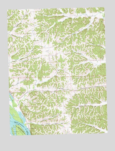
Pleasant Dale Valley, IL USGS Topographic Map
Click on map above to begin viewing in our Map Viewer.

This topographic map contains these locations and features:
Feature Name Type Latitude Longitude GNIS ID View Map
Carlin Election PrecinctCivilN39.3506°W90.6527°1928458View Map
Church of the Nazarene CampLocaleN39.2950°W90.6804°406111View Map
CliffdalePopulated PlaceN39.3606°W90.6265°422563View Map
Crater Election PrecinctCivilN39.2625°W90.6370°1928469View Map
Dog IslandIslandN39.2645°W90.7346°407280View Map
Fox CreekStreamN39.2781°W90.7448°408616View Map
Fox Creek CemeteryCemeteryN39.2925°W90.7310°408619View Map
Fox Creek School (historical)SchoolN39.2912°W90.7315°1748294View Map
Hamburg Election PrecinctCivilN39.2576°W90.7077°1928514View Map
Herrens Bess Hollow AirfieldAirportN39.3055°W90.6984°2679104View Map
Hillcrest CemeteryCemeteryN39.3437°W90.7157°410271View Map
Hillcrest ChurchChurchN39.3537°W90.7160°410272View Map
Hillcrest School (historical)SchoolN39.3500°W90.7157°1748298View Map
Howard IslandIslandN39.2537°W90.7465°719918View Map
MozierPopulated PlaceN39.2925°W90.7493°414158View Map
Mozier HollowValleyN39.2616°W90.7147°414159View Map
Mozier Hollow School (historical)SchoolN39.2642°W90.7098°1748313View Map
Mozier LandingPopulated PlaceN39.2556°W90.7260°414160View Map
Pancake HollowValleyN39.2614°W90.7249°415341View Map
Panther Creek School (historical)SchoolN39.3681°W90.6607°1748316View Map
Pleasant Dale Church (historical)ChurchN39.3528°W90.6543°1748317View Map
Pleasant Dale School (historical)SchoolN39.3295°W90.6710°1748318View Map
Pleasant Dale ValleyValleyN39.3652°W90.6396°415775View Map
Retzer CemeteryCemeteryN39.3723°W90.6729°416558View Map
Silver Creek CemeteryCemeteryN39.3245°W90.6273°418505View Map
Silver Creek School (historical)SchoolN39.3223°W90.6410°1748327View Map
Smith CemeteryCemeteryN39.3667°W90.6754°418626View Map
Spear CemeteryCemeteryN39.3698°W90.6318°418887View Map
Summit Grove ChurchChurchN39.2887°W90.6662°419351View Map
Summit Grove School (historical)SchoolN39.2859°W90.6712°1748329View Map
The SnyStreamN39.2609°W90.7326°419644View Map
Village Green School (historical)SchoolN39.3217°W90.7068°1748334View Map
West Panther Creek School (historical)SchoolN39.3220°W90.7485°1748336View Map

Note: Coordinates in the location and feature list above are referenced to NAD83 datum.


Copyright (C) 2008-2024 Ryan Niemi / Sunset Dynamics ... All Rights Reserved