TopoQuest Logo
Do you find TopoQuest useful?
Help keep TopoQuest running and adding new maps/features by donating!
Bitcoin:  19c7KJd3qBynnjoSw5npx9KScwjBe4ifkT
Litecoin:  LXs6TkuXGGXo1vDsWCkWVdjQX94eUKd6ui
Home View Maps Find Maps Find Places Resources & Links


Pearl East, Illinois Topographic Map

USGS Map Title: Pearl East, IL
USGS Map MRC: 39090D5
DRG (GeoTIFF) Download: o39090d5.tif


Neighboring USGS Topographic Map Quads:


  Milton, IL  
39090E6
 

  Bedford, IL  
39090E5
 

  Alsey, IL  
39090E4
 

  Pearl West, IL  
39090D6
 

  Pearl East, IL  
39090D5
 

  Roodhouse West, IL  
39090D4
 

  Pleasant Dale Valley, IL  
39090C6
 

  Kampsville, IL  
39090C5
 

  Carrollton, IL  
39090C4


Map MRC Location:

N40°
W91°
N40°
W90°
H8 H7 H6 H5 H4 H3 H2 H1
G8 G7 G6 G5 G4 G3 G2 G1
F8 F7 F6 F5 F4 F3 F2 F1
E8 E7 E6 E5 E4 E3 E2 E1
D8 D7 D6 D5 D4 D3 D2 D1
C8 C7 C6 C5 C4 C3 C2 C1
B8 B7 B6 B5 B4 B3 B2 B1
A8 A7 A6 A5 A4 A3 A2 A1
N39°
W91°
N39°
W90°

Pearl East, IL USGS 1:24K Topographic Map Preview:
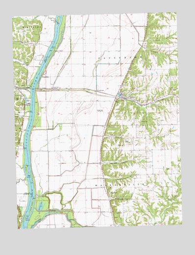
Pearl East, IL USGS Topographic Map
Click on map above to begin viewing in our Map Viewer.

This topographic map contains these locations and features:
Feature Name Type Latitude Longitude GNIS ID View Map
Bee CreekStreamN39.4012°W90.6176°404089View Map
Bettell CreekStreamN39.4698°W90.6068°404351View Map
Bishop Dale School (historical)SchoolN39.4792°W90.5201°404473View Map
Bluefield CemeteryCemeteryN39.4364°W90.5293°1748344View Map
Bridge IslandIslandN39.4603°W90.6129°404850View Map
Bridgewater CemeteryCemeteryN39.3948°W90.5546°1748346View Map
Bridgewater HollowValleyN39.3914°W90.5552°404858View Map
Brushy LakeLakeN39.3881°W90.6072°1748347View Map
Buckhorn CreekStreamN39.4984°W90.5937°405125View Map
Buckhorn IslandIslandN39.4998°W90.5882°405126View Map
Clark Lake (historical)LakeN39.4470°W90.5907°406162View Map
Coates School (historical)SchoolN39.4500°W90.5012°406312View Map
Dougal HollowValleyN39.4041°W90.5585°407332View Map
East Brushy School (historical)SchoolN39.4200°W90.5012°407617View Map
Fisher IslandIslandN39.3898°W90.6146°408400View Map
Garrison HollowValleyN39.4125°W90.5601°408913View Map
Grand PassPopulated PlaceN39.4578°W90.5962°422750View Map
Hartwell Pumping StationLocaleN39.3950°W90.6110°424970View Map
Hartwell RanchFlatN39.4189°W90.5754°409895View Map
Hartwell RanchLocaleN39.4137°W90.5612°409896View Map
Hartwell Ranch RLA AirportAirportN39.4427°W90.5569°427378View Map
Hill CreekStreamN39.4559°W90.6148°410259View Map
HillviewPopulated PlaceN39.4506°W90.5412°410301View Map
Hillview Number 1 QuarryMineN39.4542°W90.5051°1986083View Map
Hurricane CreekStreamN39.4567°W90.6104°410720View Map
Kersey CreekStreamN39.4848°W90.5304°411429View Map
Kinser CemeteryCemeteryN39.4081°W90.5112°1748382View Map
Lake View School (historical)SchoolN39.4198°W90.5612°411740View Map
Likely CemeteryCemeteryN39.4042°W90.5357°1748383View Map
Long LakeLakeN39.4339°W90.5804°412576View Map
Lower Sand Ridge School (historical)SchoolN39.4642°W90.5729°412720View Map
Martin Airport (historical)AirportN39.4170°W90.5860°427379View Map
McClay OrchardPopulated PlaceN39.4667°W90.5251°422960View Map
McWilliams School (historical)SchoolN39.4203°W90.5926°413338View Map
Oakdale School (historical)SchoolN39.3909°W90.5396°414876View Map
Old Settlers SpringSpringN39.3893°W90.5095°415058View Map
Orton Landing Field (historical)AirportN39.4231°W90.5485°1748399View Map
Scott HollowValleyN39.4280°W90.5580°418143View Map
Shelton CemeteryCemeteryN39.4489°W90.5460°1748421View Map
Spar IslandIslandN39.4078°W90.6154°418871View Map
Sweeten CemeteryCemeteryN39.3828°W90.5507°1748427View Map
Township of PattersonCivilN39.4760°W90.5241°429532View Map
Township of WalkervilleCivilN39.3977°W90.5435°429884View Map
Twin IslandsIslandN39.3828°W90.6198°419979View Map
Upper Sand Ridge School (historical)SchoolN39.4917°W90.5735°420174View Map
Village of HillviewCivilN39.4496°W90.5386°2398511View Map
Village of PearlCivilN39.4597°W90.6237°2399640View Map
Weson IslandIslandN39.4792°W90.5965°420775View Map
West Brushy School (historical)SchoolN39.4192°W90.5268°420800View Map
Wing IslandIslandN39.4109°W90.6182°421325View Map

Note: Coordinates in the location and feature list above are referenced to NAD83 datum.


Copyright (C) 2008-2024 Ryan Niemi / Sunset Dynamics ... All Rights Reserved