TopoQuest Logo
Do you find TopoQuest useful?
Help keep TopoQuest running and adding new maps/features by donating!
Bitcoin:  19c7KJd3qBynnjoSw5npx9KScwjBe4ifkT
Litecoin:  LXs6TkuXGGXo1vDsWCkWVdjQX94eUKd6ui
Home View Maps Find Maps Find Places Resources & Links


Pleasant Grove, Iowa Topographic Map

USGS Map Title: Pleasant Grove, IA
USGS Map MRC: 40091H3
DRG (GeoTIFF) Download: o40091h3.tif


Neighboring USGS Topographic Map Quads:


  Winfield South, IA  
41091A4
 

  Morning Sun, IA  
41091A3
 

  Mediapolis, IA  
41091A2
 

  New London, IA  
40091H4
 

  Pleasant Grove, IA  
40091H3
 

  Sperry, IA  
40091H2
 

  Lowell, IA  
40091G4
 

  Danville, IA  
40091G3
 

  West Burlington, IA  
40091G2


Map MRC Location:

N41°
W92°
N41°
W91°
H8 H7 H6 H5 H4 H3 H2 H1
G8 G7 G6 G5 G4 G3 G2 G1
F8 F7 F6 F5 F4 F3 F2 F1
E8 E7 E6 E5 E4 E3 E2 E1
D8 D7 D6 D5 D4 D3 D2 D1
C8 C7 C6 C5 C4 C3 C2 C1
B8 B7 B6 B5 B4 B3 B2 B1
A8 A7 A6 A5 A4 A3 A2 A1
N40°
W92°
N40°
W91°

Pleasant Grove, IA USGS 1:24K Topographic Map Preview:
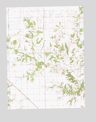
Pleasant Grove, IA USGS Topographic Map
Click on map above to begin viewing in our Map Viewer.

This topographic map contains these locations and features:
Feature Name Type Latitude Longitude GNIS ID View Map
Big Hollow CreekStreamN40.9186°W91.2665°1823556View Map
Butcher CemeteryCemeteryN40.9578°W91.2570°1823557View Map
Carter CemeteryCemeteryN40.9262°W91.3123°1823559View Map
Cedar Fork CreekStreamN40.9281°W91.2757°1825040View Map
Fan Post Office (historical)Post OfficeN40.8778°W91.2529°1994913View Map
Gallaher CemeteryCemeteryN40.9742°W91.2621°1823561View Map
Millerburg CemeteryCemeteryN40.9698°W91.3389°1823560View Map
Pleasant GrovePopulated PlaceN40.9675°W91.2879°460219View Map
Pleasantgrove Post Office (historical)Post OfficeN40.9675°W91.2879°1994918View Map
Prairie GrovePopulated PlaceN40.8792°W91.2524°460412View Map
Ramsey CemeteryCemeteryN40.9296°W91.3381°1823558View Map
Shinar Cumberland Presbyterian CemeteryCemeteryN40.9693°W91.2868°1995165View Map
Shinar Cumberland Presbyterian Church CemeteryCemeteryN40.9691°W91.2854°2705939View Map
Siefken Family PlotCemeteryN40.9084°W91.2863°1995164View Map
Stage Coach Depot Historical MarkerParkN40.8873°W91.3427°1995199View Map
Township of Pleasant GroveCivilN40.9435°W91.3141°468538View Map
Welsh Chapel CemeteryCemeteryN40.9945°W91.2515°1995140View Map

Note: Coordinates in the location and feature list above are referenced to NAD83 datum.


Copyright (C) 2008-2025 Ryan Niemi / Sunset Dynamics ... All Rights Reserved