TopoQuest Logo
Do you find TopoQuest useful?
Help keep TopoQuest running and adding new maps/features by donating!
Bitcoin:  19c7KJd3qBynnjoSw5npx9KScwjBe4ifkT
Litecoin:  LXs6TkuXGGXo1vDsWCkWVdjQX94eUKd6ui
Home View Maps Find Maps Find Places Resources & Links


Poland, Indiana Topographic Map

USGS Map Title: Poland, IN
USGS Map MRC: 39086D8
DRG (GeoTIFF) Download: o39086d8.tif


Neighboring USGS Topographic Map Quads:


  Brazil East, IN  
39087E1
 

  Reelsville, IN  
39086E8
 

  Cloverdale, IN  
39086E7
 

  Center Point, IN  
39087D1
 

  Poland, IN  
39086D8
 

  Cataract, IN  
39086D7
 

  Clay City, IN  
39087C1
 

  Patricksburg, IN  
39086C8
 

  Spencer, IN  
39086C7


Map MRC Location:

N40°
W87°
N40°
W86°
H8 H7 H6 H5 H4 H3 H2 H1
G8 G7 G6 G5 G4 G3 G2 G1
F8 F7 F6 F5 F4 F3 F2 F1
E8 E7 E6 E5 E4 E3 E2 E1
D8 D7 D6 D5 D4 D3 D2 D1
C8 C7 C6 C5 C4 C3 C2 C1
B8 B7 B6 B5 B4 B3 B2 B1
A8 A7 A6 A5 A4 A3 A2 A1
N39°
W87°
N39°
W86°

Poland, IN USGS 1:24K Topographic Map Preview:
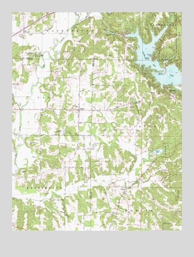
Poland, IN USGS Topographic Map
Click on map above to begin viewing in our Map Viewer.

This topographic map contains these locations and features:
Feature Name Type Latitude Longitude GNIS ID View Map
Ahlemeyer BranchStreamN39.4350°W86.9933°430029View Map
Barnes LakeReservoirN39.4203°W86.8924°430506View Map
Barnes Lake DamDamN39.4201°W86.8963°447882View Map
Big Walnut CreekStreamN39.4953°W86.9514°431073View Map
Buck CreekStreamN39.4600°W86.9808°431715View Map
Cagle CemeteryCemeteryN39.4514°W86.9631°431939View Map
Cagle MillPopulated PlaceN39.4873°W86.9397°431940View Map
Cagles Mill LakeReservoirN39.4645°W86.8829°431941View Map
Cagles Mill Lake DamDamN39.4864°W86.9175°448703View Map
Camp Na-Wa-KwaParkN39.4323°W86.9636°432050View Map
Coon CreekStreamN39.4181°W86.9564°432932View Map
Cromwell HillSummitN39.4245°W86.9878°433149View Map
Croys CreekStreamN39.4756°W86.9775°433221View Map
Drake HillSummitN39.4087°W86.9931°433682View Map
Fall CreekStreamN39.4923°W86.9464°434369View Map
Fertig CemeteryCemeteryN39.4651°W86.9042°434463View Map
Grable CemeteryCemeteryN39.4908°W86.9542°435252View Map
Greeley CemeteryCemeteryN39.4772°W86.9615°435384View Map
Hulman BeachBeachN39.4737°W86.9458°436599View Map
JordanPopulated PlaceN39.3984°W86.9167°437109View Map
Keiser HillSummitN39.4453°W86.9453°437199View Map
King CreekStreamN39.4181°W86.9567°437323View Map
Knob CreekStreamN39.4106°W86.9956°437400View Map
Krietenste CampParkN39.4753°W86.9772°437460View Map
Middle NarrowsChannelN39.4664°W86.9492°439106View Map
Mill CreekStreamN39.4953°W86.9511°439158View Map
Muddy BranchStreamN39.3956°W86.9639°439850View Map
Nier CemeteryCemeteryN39.4462°W86.9724°440172View Map
North Fork Jordan CreekStreamN39.4181°W86.9564°440253View Map
Oak Grove ChurchChurchN39.4542°W86.9525°440422View Map
Owl HollowValleyN39.4355°W86.9075°440812View Map
PolandPopulated PlaceN39.4442°W86.9508°441396View Map
Poland Community Volunteer Fire DepartmentBuildingN39.4426°W86.9504°2626056View Map
Raab CrossroadsPopulated PlaceN39.4878°W86.9920°441705View Map
Richard Lieber State ParkParkN39.4792°W86.8833°446952View Map
Sand HillSummitN39.4395°W86.9550°442976View Map
Slate RunStreamN39.4848°W86.9614°443596View Map
Tillman CreekStreamN39.4448°W86.9936°444762View Map
Township of CassCivilN39.4517°W86.9780°453162View Map
Township of JacksonCivilN39.4371°W86.8982°453459View Map
Township of WashingtonCivilN39.3854°W86.9994°453988View Map
Wilkerson - Nees CemeteryCemeteryN39.4408°W86.9797°446038View Map
Zion ChurchChurchN39.4298°W86.9517°446457View Map

Note: Coordinates in the location and feature list above are referenced to NAD83 datum.


Copyright (C) 2008-2025 Ryan Niemi / Sunset Dynamics ... All Rights Reserved