TopoQuest Logo
Do you find TopoQuest useful?
Help keep TopoQuest running and adding new maps/features by donating!
Bitcoin:  19c7KJd3qBynnjoSw5npx9KScwjBe4ifkT
Litecoin:  LXs6TkuXGGXo1vDsWCkWVdjQX94eUKd6ui
Home View Maps Find Maps Find Places Resources & Links


Cloverdale, Indiana Topographic Map

USGS Map Title: Cloverdale, IN
USGS Map MRC: 39086E7
DRG (GeoTIFF) Download: o39086e7.tif


Neighboring USGS Topographic Map Quads:


  Clinton Falls, IN  
39086F8
 

  Greencastle, IN  
39086F7
 

  Coatesville, IN  
39086F6
 

  Reelsville, IN  
39086E8
 

  Cloverdale, IN  
39086E7
 

  Eminence, IN  
39086E6
 

  Poland, IN  
39086D8
 

  Cataract, IN  
39086D7
 

  Quincy, IN  
39086D6


Map MRC Location:

N40°
W87°
N40°
W86°
H8 H7 H6 H5 H4 H3 H2 H1
G8 G7 G6 G5 G4 G3 G2 G1
F8 F7 F6 F5 F4 F3 F2 F1
E8 E7 E6 E5 E4 E3 E2 E1
D8 D7 D6 D5 D4 D3 D2 D1
C8 C7 C6 C5 C4 C3 C2 C1
B8 B7 B6 B5 B4 B3 B2 B1
A8 A7 A6 A5 A4 A3 A2 A1
N39°
W87°
N39°
W86°

Cloverdale, IN USGS 1:24K Topographic Map Preview:
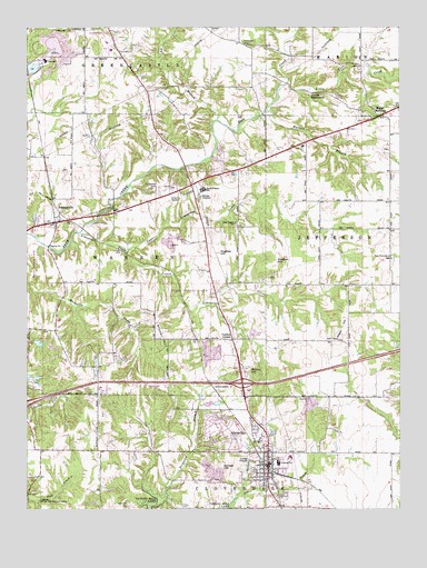
Cloverdale, IN USGS Topographic Map
Click on map above to begin viewing in our Map Viewer.

This topographic map contains these locations and features:
Feature Name Type Latitude Longitude GNIS ID View Map
Clover Knoll AirportAirportN39.5317°W86.8290°2677028View Map
CloverdalePopulated PlaceN39.5148°W86.7939°432688View Map
Cloverdale Elementary SchoolSchoolN39.5120°W86.7908°447155View Map
Cloverdale Junior/Senior High SchoolSchoolN39.5120°W86.7908°447154View Map
Cloverdale Police DepartmentBuildingN39.5098°W86.7945°2758069View Map
Cloverdale QuarryMineN39.5397°W86.8142°2564627View Map
Cloverdale Township Volunteer Fire DepartmentBuildingN39.5119°W86.7953°2625906View Map
Cradick CornerPopulated PlaceN39.5439°W86.8058°433076View Map
Deer Creek ChurchChurchN39.5742°W86.8050°433433View Map
Devils BackboneRidgeN39.6081°W86.7781°433505View Map
Doe Creek CemeteryCemeteryN39.5008°W86.8410°433602View Map
Dogwood Springs LakeReservoirN39.5431°W86.8708°448809View Map
Dogwood Springs Lake DamDamN39.5450°W86.8717°448810View Map
Flatwoods CemeteryCemeteryN39.6205°W86.8017°434576View Map
Greyhound LakeReservoirN39.5342°W86.8713°448812View Map
Greyhound Lake DamDamN39.5342°W86.8728°448811View Map
Hadden HillSummitN39.5653°W86.7906°435583View Map
Hughes HillSummitN39.5673°W86.8117°436597View Map
Limedale QuarryMineN39.6147°W86.8617°2567526View Map
Limestone CreekStreamN39.5717°W86.8572°437902View Map
Little Deer CreekStreamN39.6100°W86.7878°438038View Map
Lower Limestone CreekStreamN39.5656°W86.8414°438368View Map
McCoy HillSummitN39.5359°W86.8008°438823View Map
Moser HillSummitN39.5495°W86.7675°439484View Map
Mount MeridianPopulated PlaceN39.6020°W86.7575°439601View Map
New Providence CemeteryCemeteryN39.5650°W86.7522°440103View Map
Old Bethel CemeteryCemeteryN39.5838°W86.8317°440537View Map
Owens FieldAirportN39.6102°W86.7542°2677045View Map
Owl BranchStreamN39.6012°W86.8111°440802View Map
Putnam County HospitalHospitalN39.6215°W86.8477°2628992View Map
Putnam County Operation Life - Cloverdale SubstationBuildingN39.5161°W86.7932°2719377View Map
Putnam County Stone PitMineN39.5397°W86.8117°2649682View Map
PutnamvillePopulated PlaceN39.5742°W86.8653°441673View Map
Rabbit RunStreamN39.5037°W86.8042°441709View Map
Sanders GyroportAirportN39.5142°W86.7655°2677110View Map
Snyder HillSummitN39.5481°W86.8317°443748View Map
South Putnam High SchoolSchoolN39.5828°W86.8158°443842View Map
Sunset HillSummitN39.5112°W86.8095°444423View Map
Town of CloverdaleCivilN39.5212°W86.7996°2396656View Map
Township of CloverdaleCivilN39.5004°W86.7952°453235View Map
Township of WarrenCivilN39.5662°W86.8490°453977View Map
Upper Limestone CreekStreamN39.5667°W86.8414°445168View Map
Wallace BranchStreamN39.6031°W86.7953°445388View Map
WestlandPopulated PlaceN39.5834°W86.8458°452226View Map

Note: Coordinates in the location and feature list above are referenced to NAD83 datum.


Copyright (C) 2008-2025 Ryan Niemi / Sunset Dynamics ... All Rights Reserved