TopoQuest Logo
Do you find TopoQuest useful?
Help keep TopoQuest running and adding new maps/features by donating!
Bitcoin:  19c7KJd3qBynnjoSw5npx9KScwjBe4ifkT
Litecoin:  LXs6TkuXGGXo1vDsWCkWVdjQX94eUKd6ui
Home View Maps Find Maps Find Places Resources & Links


Reelsville, Indiana Topographic Map

USGS Map Title: Reelsville, IN
USGS Map MRC: 39086E8
DRG (GeoTIFF) Download: o39086e8.tif


Neighboring USGS Topographic Map Quads:


  Mansfield, IN  
39087F1
 

  Clinton Falls, IN  
39086F8
 

  Greencastle, IN  
39086F7
 

  Brazil East, IN  
39087E1
 

  Reelsville, IN  
39086E8
 

  Cloverdale, IN  
39086E7
 

  Center Point, IN  
39087D1
 

  Poland, IN  
39086D8
 

  Cataract, IN  
39086D7


Map MRC Location:

N40°
W87°
N40°
W86°
H8 H7 H6 H5 H4 H3 H2 H1
G8 G7 G6 G5 G4 G3 G2 G1
F8 F7 F6 F5 F4 F3 F2 F1
E8 E7 E6 E5 E4 E3 E2 E1
D8 D7 D6 D5 D4 D3 D2 D1
C8 C7 C6 C5 C4 C3 C2 C1
B8 B7 B6 B5 B4 B3 B2 B1
A8 A7 A6 A5 A4 A3 A2 A1
N39°
W87°
N39°
W86°

Reelsville, IN USGS 1:24K Topographic Map Preview:
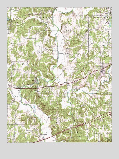
Reelsville, IN USGS Topographic Map
Click on map above to begin viewing in our Map Viewer.

This topographic map contains these locations and features:
Feature Name Type Latitude Longitude GNIS ID View Map
Antioch ChurchChurchN39.6034°W86.9033°430211View Map
Beacon RunStreamN39.5495°W86.9978°430599View Map
Big Walnut ChurchChurchN39.5237°W86.9511°431072View Map
Boone - Hutcheson CemeteryCemeteryN39.5869°W86.9297°431340View Map
Canaan RunStreamN39.5503°W86.9981°432097View Map
Community ChurchChurchN39.6173°W86.8817°432834View Map
Cooper FieldAirportN39.5845°W86.9542°2717322View Map
Deer CreekStreamN39.5006°W86.9372°433426View Map
Deweese BranchStreamN39.5500°W86.9225°433520View Map
Fern CliffCliffN39.6098°W86.9620°434457View Map
Hamricks Station Post Office (historical)Post OfficeN39.5823°W86.9153°453041View Map
Houck Covered BridgeBridgeN39.5823°W86.9395°436513View Map
Huffman Covered BridgeBridgeN39.5081°W86.9581°436586View Map
Indian RidgeRidgeN39.5042°W86.9131°436781View Map
Indiana State Police Department District 53BuildingN39.5683°W86.8878°2758294View Map
JenkinsvillePopulated PlaceN39.5328°W86.8753°452224View Map
Johnson BranchStreamN39.5428°W86.9853°437031View Map
Leatherwood CreekStreamN39.5325°W86.9239°437710View Map
LimedalePopulated PlaceN39.6192°W86.8792°437898View Map
Little Walnut CreekStreamN39.6237°W86.9431°438169View Map
Lower Boone CemeteryCemeteryN39.5525°W86.9868°431338View Map
Maiden RunStreamN39.5612°W86.9620°438481View Map
ManhattanPopulated PlaceN39.5550°W86.9275°438515View Map
Manhattan QuarryMineN39.5506°W86.9172°2649584View Map
Manhatten Covered BridgeBridgeN39.5498°W86.9228°438516View Map
Matkin CemeteryCemeteryN39.5065°W86.9607°438722View Map
Mosquito CreekStreamN39.5612°W86.8770°439494View Map
Mount Hebrow ChurchChurchN39.5159°W86.8770°439575View Map
Okalla StationLocaleN39.6178°W86.9500°452225View Map
Pleasant GardensPopulated PlaceN39.5514°W86.9645°441242View Map
Putnamville Correctional FacilityBuildingN39.5671°W86.8869°2757187View Map
Putnamville Correctional Facility Fire DepartmentBuildingN39.5650°W86.8851°2626421View Map
Putnamville QuarryMineN39.5356°W86.8825°2567530View Map
ReelsvillePopulated PlaceN39.5575°W86.9670°441866View Map
Reelsville - Washington Township Volunteer Fire DepartmentBuildingN39.5492°W86.9639°2626365View Map
Reelsville Elementary SchoolSchoolN39.5478°W86.9645°441867View Map
Rocky ForkStreamN39.5459°W86.9045°442230View Map
Salem CemeteryCemeteryN39.5154°W86.8875°442883View Map
Snake CreekStreamN39.5998°W86.9436°443724View Map
Thomas LakeReservoirN39.6139°W86.9991°447862View Map
Township of WashingtonCivilN39.5387°W86.9586°454015View Map

Note: Coordinates in the location and feature list above are referenced to NAD83 datum.


Copyright (C) 2008-2024 Ryan Niemi / Sunset Dynamics ... All Rights Reserved