TopoQuest Logo
Do you find TopoQuest useful?
Help keep TopoQuest running and adding new maps/features by donating!
Bitcoin:  19c7KJd3qBynnjoSw5npx9KScwjBe4ifkT
Litecoin:  LXs6TkuXGGXo1vDsWCkWVdjQX94eUKd6ui
Home View Maps Find Maps Find Places Resources & Links


Polkville, Mississippi Topographic Map

USGS Map Title: Polkville, MS
USGS Map MRC: 32089B6
DRG (GeoTIFF) Download: o32089b6.tif


Neighboring USGS Topographic Map Quads:


  Pelahatchie, MS  
32089C7
 

  Morton, MS  
32089C6
 

  Pulaski, MS  
32089C5
 

  Johns, MS  
32089B7
 

  Polkville, MS  
32089B6
 

  Homewood, MS  
32089B5
 

  Puckett, MS  
32089A7
 

  White Oak, MS  
32089A6
 

  Raleigh, MS  
32089A5


Map MRC Location:

N33°
W90°
N33°
W89°
H8 H7 H6 H5 H4 H3 H2 H1
G8 G7 G6 G5 G4 G3 G2 G1
F8 F7 F6 F5 F4 F3 F2 F1
E8 E7 E6 E5 E4 E3 E2 E1
D8 D7 D6 D5 D4 D3 D2 D1
C8 C7 C6 C5 C4 C3 C2 C1
B8 B7 B6 B5 B4 B3 B2 B1
A8 A7 A6 A5 A4 A3 A2 A1
N32°
W90°
N32°
W89°

Polkville, MS USGS 1:24K Topographic Map Preview:
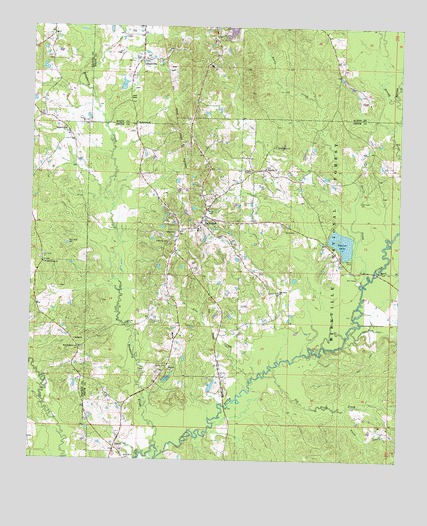
Polkville, MS USGS Topographic Map
Click on map above to begin viewing in our Map Viewer.

This topographic map contains these locations and features:
Feature Name Type Latitude Longitude GNIS ID View Map
Beaver LakeReservoirN32.1885°W89.6448°692512View Map
Beech BranchStreamN32.1785°W89.6334°692522View Map
Bethel ChurchChurchN32.1593°W89.7351°692559View Map
Concord CemeteryCemeteryN32.2207°W89.7392°709012View Map
Concord ChurchChurchN32.2201°W89.7392°692957View Map
CoopervillePopulated PlaceN32.2407°W89.7131°692972View Map
Cooperville Baptist ChurchChurchN32.2404°W89.7115°704952View Map
DanielPopulated PlaceN32.1282°W89.7209°693047View Map
Davis CreekStreamN32.1765°W89.6376°693061View Map
Field CreekStreamN32.1399°W89.6456°693210View Map
Hailes CemeteryCemeteryN32.1913°W89.6609°693395View Map
Herbert Cooper Pond DamDamN32.2285°W89.7201°695427View Map
Homestead ChurchChurchN32.2226°W89.7151°671378View Map
Hughes Lake DamDamN32.1452°W89.6917°695422View Map
James CemeteryCemeteryN32.1517°W89.7069°693599View Map
Line CreekStreamN32.1482°W89.6756°693728View Map
New Prospect CemeteryCemeteryN32.1575°W89.7319°709123View Map
New Prospect ChurchChurchN32.1574°W89.7331°694183View Map
Oak Grove ChurchChurchN32.1738°W89.6662°694230View Map
Oak Grove Church of God CemeteryCemeteryN32.1742°W89.6656°2781338View Map
Old Field CreekStreamN32.1496°W89.6701°694260View Map
Old Polkville CemeteryCemeteryN32.1881°W89.7030°694450View Map
Piney Grove (historical)LocaleN32.2154°W89.6681°707257View Map
Piney Grove ChurchChurchN32.2157°W89.6679°694401View Map
PolkvillePopulated PlaceN32.1938°W89.6926°694449View Map
Polkville Attendance CenterSchoolN32.1918°W89.6934°707259View Map
Polkville ChurchChurchN32.2093°W89.6709°694451View Map
Polkville First Baptist ChurchChurchN32.1921°W89.6929°704932View Map
Polkville Pentecostal CemeteryCemeteryN32.2097°W89.6709°2766915View Map
Raspberry CreekStreamN32.1290°W89.7073°694513View Map
Robinson CreekStreamN32.2299°W89.6262°694586View Map
Rock Bluff CemeteryCemeteryN32.1251°W89.7166°694588View Map
S Cooper Lake DamDamN32.2468°W89.6817°695430View Map
Stubb School (historical)SchoolN32.1557°W89.6848°704936View Map
Town of PolkvilleCivilN32.1909°W89.6960°2407528View Map
Walters Grove CemeteryCemeteryN32.1830°W89.7467°709173View Map
Waters Grove ChurchChurchN32.1815°W89.7459°695104View Map
Zion ChurchChurchN32.1521°W89.7026°695237View Map

Note: Coordinates in the location and feature list above are referenced to NAD83 datum.


Copyright (C) 2008-2024 Ryan Niemi / Sunset Dynamics ... All Rights Reserved