TopoQuest Logo
Do you find TopoQuest useful?
Help keep TopoQuest running and adding new maps/features by donating!
Bitcoin:  19c7KJd3qBynnjoSw5npx9KScwjBe4ifkT
Litecoin:  LXs6TkuXGGXo1vDsWCkWVdjQX94eUKd6ui
Home View Maps Find Maps Find Places Resources & Links


Post Lake, Wisconsin Topographic Map

USGS Map Title: Post Lake, WI
USGS Map MRC: 45089D1
DRG (GeoTIFF) Download: o45089d1.tif


Neighboring USGS Topographic Map Quads:


  Monico, WI  
45089E2
 

  Nashville, WI  
45089E1
 

  Crandon, WI  
45088E8
 

  Elcho, WI  
45089D2
 

  Post Lake, WI  
45089D1
 

  Mole Lake, WI  
45088D8
 

  Kempster, WI  
45089C2
 

  Pearson, WI  
45089C1
 

  Pickerel, WI  
45088C8


Map MRC Location:

N46°
W90°
N46°
W89°
H8 H7 H6 H5 H4 H3 H2 H1
G8 G7 G6 G5 G4 G3 G2 G1
F8 F7 F6 F5 F4 F3 F2 F1
E8 E7 E6 E5 E4 E3 E2 E1
D8 D7 D6 D5 D4 D3 D2 D1
C8 C7 C6 C5 C4 C3 C2 C1
B8 B7 B6 B5 B4 B3 B2 B1
A8 A7 A6 A5 A4 A3 A2 A1
N45°
W90°
N45°
W89°

Post Lake, WI USGS 1:24K Topographic Map Preview:
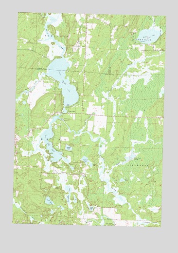
Post Lake, WI USGS Topographic Map
Click on map above to begin viewing in our Map Viewer.

This topographic map contains these locations and features:
Feature Name Type Latitude Longitude GNIS ID View Map
Aninnan LakeLakeN45.4137°W89.0651°1560876View Map
Bishop LakeLakeN45.4878°W89.0141°1561830View Map
Knoke SpringSpringN45.3975°W89.0915°1567577View Map
Logan CreekStreamN45.4922°W89.0104°1568493View Map
Loon LakeLakeN45.3886°W89.0947°1568619View Map
Lost CreekStreamN45.4022°W89.0448°1568644View Map
Lost LakeLakeN45.4022°W89.0338°1568660View Map
Lower Post LakeLakeN45.4153°W89.0891°1568753View Map
Marigold LakeLakeN45.4549°W89.0015°2784073View Map
Miniwakan LakeLakeN45.3901°W89.0789°1569559View Map
Mud CreekStreamN45.4314°W89.0693°1569882View Map
Mud CreekStreamN45.4380°W89.0901°1569883View Map
Pedro CreekStreamN45.4850°W89.0982°1571146View Map
Perch LakeLakeN45.3855°W89.0596°1571203View Map
Perch LakeLakeN45.4109°W89.0603°1571204View Map
Pickerel CreekStreamN45.3777°W89.0198°1571311View Map
Pollock CreekStreamN45.4636°W89.0998°1571742View Map
Post LakePopulated PlaceN45.4408°W89.0804°1571820View Map
Post Lake Census Designated PlaceCensusN45.4351°W89.0921°2586546View Map
Spider CreekStreamN45.4014°W89.0473°1574538View Map
Spider Creek 2WP1403 DamDamN45.4116°W89.0334°1792174View Map
Spider Creek FlowageReservoirN45.4156°W89.0282°1792175View Map
Squaw CreekStreamN45.4719°W89.0254°1574758View Map
Swamp CreekStreamN45.4241°W89.0521°1580564View Map
Upper LakeReservoirN45.4383°W89.0851°1792880View Map
Upper Post LakeLakeN45.4596°W89.0853°1575989View Map
Upper Post Lake 1866C352 DamDamN45.4383°W89.0851°1792879View Map
Walczak CreekStreamN45.4722°W89.0837°1576150View Map
Wamin LakeLakeN45.4204°W89.0796°1576187View Map

Note: Coordinates in the location and feature list above are referenced to NAD83 datum.


Copyright (C) 2008-2025 Ryan Niemi / Sunset Dynamics ... All Rights Reserved