TopoQuest Logo
Do you find TopoQuest useful?
Help keep TopoQuest running and adding new maps/features by donating!
Bitcoin:  19c7KJd3qBynnjoSw5npx9KScwjBe4ifkT
Litecoin:  LXs6TkuXGGXo1vDsWCkWVdjQX94eUKd6ui
Home View Maps Find Maps Find Places Resources & Links


Prairie Grove, Arkansas Topographic Map

USGS Map Title: Prairie Grove, AR
USGS Map MRC: 35094H3
DRG (GeoTIFF) Download: o35094h3.tif


Neighboring USGS Topographic Map Quads:


  Rhea, AR  
36094A4
 

  Wheeler, AR  
36094A3
 

  Fayetteville, AR  
36094A2
 

  Lincoln, AR  
35094H4
 

  Prairie Grove, AR  
35094H3
 

  West Fork, AR  
35094H2
 

  Evansville, AR  
35094G4
 

  Strickler, AR  
35094G3
 

  Winslow, AR  
35094G2


Map MRC Location:

N36°
W95°
N36°
W94°
H8 H7 H6 H5 H4 H3 H2 H1
G8 G7 G6 G5 G4 G3 G2 G1
F8 F7 F6 F5 F4 F3 F2 F1
E8 E7 E6 E5 E4 E3 E2 E1
D8 D7 D6 D5 D4 D3 D2 D1
C8 C7 C6 C5 C4 C3 C2 C1
B8 B7 B6 B5 B4 B3 B2 B1
A8 A7 A6 A5 A4 A3 A2 A1
N35°
W95°
N35°
W94°

Prairie Grove, AR USGS 1:24K Topographic Map Preview:
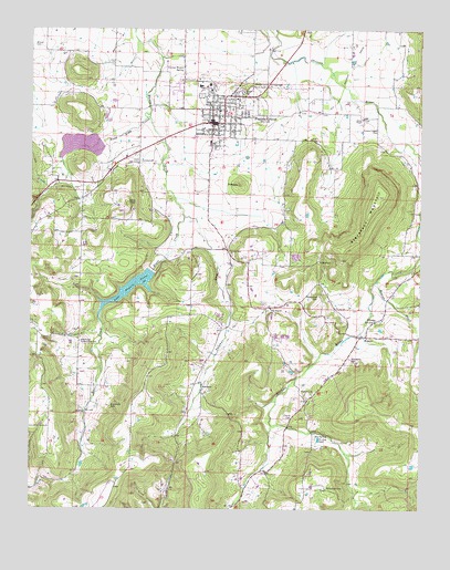
Prairie Grove, AR USGS Topographic Map
Click on map above to begin viewing in our Map Viewer.

This topographic map contains these locations and features:
Feature Name Type Latitude Longitude GNIS ID View Map
Big SpringSpringN35.8937°W94.2835°46605View Map
Big Spring Church (historical)ChurchN35.8884°W94.2938°65287View Map
Billingsley CemeteryCemeteryN35.9134°W94.2719°46621View Map
Billingsley ChurchChurchN35.9240°W94.2647°46622View Map
Blair CreekStreamN35.9562°W94.3294°46703View Map
Budd Kidd CreekStreamN35.9779°W94.3377°76457View Map
Budd Kidd LakeReservoirN35.9699°W94.3602°80919View Map
Cane Hill MountainSummitN35.9412°W94.3719°65298View Map
Center Point ChurchChurchN35.9423°W94.3116°47643View Map
Centre Point School (historical)SchoolN35.9423°W94.3119°65306View Map
City of Prairie GroveCivilN35.9858°W94.3049°2404567View Map
Hickory CreekStreamN35.9681°W94.2508°50050View Map
HogeyePopulated PlaceN35.9204°W94.2677°81869View Map
Hogeye CreekStreamN35.9345°W94.2640°50172View Map
Howell CemeteryCemeteryN35.9056°W94.2838°50368View Map
HubbardPopulated PlaceN35.9054°W94.3199°77247View Map
Hubbard Post Office (historical)Post OfficeN35.9070°W94.3197°84310View Map
Illinois ChapelChurchN35.9767°W94.2691°50482View Map
Illinois Chapel CemeteryCemeteryN35.9737°W94.2641°50483View Map
Lake Prairie GroveReservoirN35.9327°W94.3430°75825View Map
Liberty School (historical)SchoolN35.9579°W94.3549°65378View Map
Living Waters SpringSpringN35.9892°W94.3269°51349View Map
McDonald CemeteryCemeteryN35.8806°W94.2802°51824View Map
Moffit Post Office (historical)Post OfficeN35.9215°W94.2669°84312View Map
Muddy Fork of Illinois Site Number 3 DamDamN35.9701°W94.3535°80918View Map
New Hope CemeteryCemeteryN35.9020°W94.3494°52664View Map
New Hope Community HallLocaleN35.9190°W94.3594°52702View Map
New Hope School (historical)SchoolN35.9187°W94.3594°65393View Map
New Sulphur ChurchChurchN35.9273°W94.2980°52742View Map
North Mayberry MountainSummitN35.9890°W94.3588°65395View Map
Parks CemeteryCemeteryN35.8990°W94.2908°53194View Map
PinnacleSummitN35.9598°W94.3085°58389View Map
Prairie GrovePopulated PlaceN35.9759°W94.3177°78091View Map
Prairie Grove Battlefield State ParkParkN35.9845°W94.3019°53772View Map
Prairie Grove Elementary SchoolSchoolN35.9847°W94.3259°65413View Map
Prairie Grove High SchoolSchoolN35.9815°W94.3245°65414View Map
Prairie Grove Lake DamDamN35.9367°W94.3369°79744View Map
Prairie Grove Middle SchoolSchoolN35.9848°W94.3178°2039054View Map
Prairie Grove Upper Elementary SchoolSchoolN35.9853°W94.3213°2039053View Map
Prairie Grove Volunteer Fire DepartmentBuildingN35.9747°W94.3151°2117001View Map
Prarie Grove Police DepartmentBuildingN35.9755°W94.3157°2118941View Map
Rutherford CemeteryCemeteryN35.9308°W94.2829°54292View Map
Sharp CemeteryCemeteryN35.9395°W94.2830°54735View Map
South Mayberry MountainSummitN35.9779°W94.3572°65449View Map
Stevenson MountainSummitN35.9542°W94.2655°58687View Map
Sulphur ForkStreamN35.9512°W94.3263°78491View Map
Sweetwater CreekStreamN35.8967°W94.2977°65464View Map
Township of Prairie GroveCivilN35.9717°W94.3062°69798View Map
Township of ValleyCivilN35.9017°W94.2723°69806View Map
Wolf MountainSummitN35.9634°W94.3585°65500View Map

Note: Coordinates in the location and feature list above are referenced to NAD83 datum.


Copyright (C) 2008-2024 Ryan Niemi / Sunset Dynamics ... All Rights Reserved