TopoQuest Logo
Do you find TopoQuest useful?
Help keep TopoQuest running and adding new maps/features by donating!
Bitcoin:  19c7KJd3qBynnjoSw5npx9KScwjBe4ifkT
Litecoin:  LXs6TkuXGGXo1vDsWCkWVdjQX94eUKd6ui
Home View Maps Find Maps Find Places Resources & Links


Proctor, Oklahoma Topographic Map

USGS Map Title: Proctor, OK
USGS Map MRC: 35094H7
DRG (GeoTIFF) Download: o35094h7.tif


Neighboring USGS Topographic Map Quads:


  Moodys, OK  
36094A8
 

  Chewey, OK  
36094A7
 

  Chance, OK  
36094A6
 

  Tahlequah, OK  
35094H8
 

  Proctor, OK  
35094H7
 

  Christie, OK  
35094H6
 

  Park Hill, OK  
35094G8
 

  Tailholt, OK  
35094G7
 

  Stilwell West, OK  
35094G6


Map MRC Location:

N36°
W95°
N36°
W94°
H8 H7 H6 H5 H4 H3 H2 H1
G8 G7 G6 G5 G4 G3 G2 G1
F8 F7 F6 F5 F4 F3 F2 F1
E8 E7 E6 E5 E4 E3 E2 E1
D8 D7 D6 D5 D4 D3 D2 D1
C8 C7 C6 C5 C4 C3 C2 C1
B8 B7 B6 B5 B4 B3 B2 B1
A8 A7 A6 A5 A4 A3 A2 A1
N35°
W95°
N35°
W94°

Proctor, OK USGS 1:24K Topographic Map Preview:
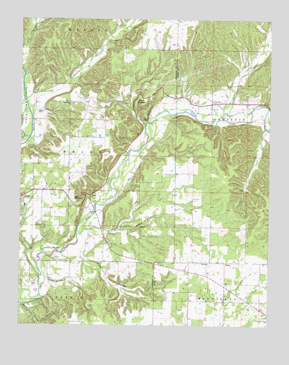
Proctor, OK USGS Topographic Map
Click on map above to begin viewing in our Map Viewer.

This topographic map contains these locations and features:
Feature Name Type Latitude Longitude GNIS ID View Map
BriggsCivilN35.9553°W94.8544°2631076View Map
BriggsPopulated PlaceN35.9270°W94.8747°1100234View Map
Briggs Elementary SchoolSchoolN35.9235°W94.8728°1790724View Map
Camp EganLocaleN35.9593°W94.8138°1090858View Map
Cobb Family CemeteryCemeteryN35.9298°W94.8639°2711307View Map
EldonPopulated PlaceN35.9281°W94.8402°1100385View Map
EldonCivilN35.9342°W94.8252°2631104View Map
Eldon Census Designated PlaceCensusN35.9304°W94.8179°2408068View Map
Eldon MountainSummitN35.9270°W94.8486°1092518View Map
Field HollowValleyN35.9045°W94.8449°1092801View Map
Long Spring ChurchChurchN35.9662°W94.8513°1094971View Map
Mining Camp HollowValleyN35.8834°W94.8733°1095435View Map
New Spring Place (historical)Populated PlaceN35.9922°W94.7971°2437430View Map
Oakdale ChurchChurchN35.9620°W94.8663°1096139View Map
ProctorPopulated PlaceN35.9662°W94.7775°1100765View Map
Proctor Census Designated PlaceCensusN35.9759°W94.7511°2584390View Map
Proctor ChurchChurchN35.9615°W94.7694°1096936View Map
Proctor MountainSummitN35.9665°W94.8175°1096938View Map
Proctor-Sanders Community CemeteryCemeteryN35.9619°W94.7694°2712403View Map
Pumpkin Center CemeteryCemeteryN35.9912°W94.8324°1096956View Map
Pumpkin HollowValleyN35.9656°W94.8686°1096960View Map
Shirley CemeteryCemeteryN35.9119°W94.8390°2746187View Map
TitanicPopulated PlaceN35.9009°W94.7722°1100889View Map
Township of BriggsCivilN35.9459°W94.8405°1824591View Map
Tyner CreekStreamN35.9598°W94.7741°1099134View Map
Wall Trip BranchStreamN35.9112°W94.8463°1099311View Map
Welling Tri - Community Fire Department Station 2BuildingN35.9407°W94.8505°2657391View Map
Willow Branch CreekStreamN35.8912°W94.8650°1099852View Map

Note: Coordinates in the location and feature list above are referenced to NAD83 datum.


Copyright (C) 2008-2025 Ryan Niemi / Sunset Dynamics ... All Rights Reserved