TopoQuest Logo
Do you find TopoQuest useful?
Help keep TopoQuest running and adding new maps/features by donating!
Bitcoin:  19c7KJd3qBynnjoSw5npx9KScwjBe4ifkT
Litecoin:  LXs6TkuXGGXo1vDsWCkWVdjQX94eUKd6ui
Home View Maps Find Maps Find Places Resources & Links


Stilwell West, Oklahoma Topographic Map

USGS Map Title: Stilwell West, OK
USGS Map MRC: 35094G6
DRG (GeoTIFF) Download: o35094g6.tif


Neighboring USGS Topographic Map Quads:


  Proctor, OK  
35094H7
 

  Christie, OK  
35094H6
 

  Westville, OK  
35094H5
 

  Tailholt, OK  
35094G7
 

  Stilwell West, OK  
35094G6
 

  Stilwell East, OK  
35094G5
 

  Bunch, OK  
35094F7
 

  Greasy, OK  
35094F6
 

  Big Round Mountain, OK  
35094F5


Map MRC Location:

N36°
W95°
N36°
W94°
H8 H7 H6 H5 H4 H3 H2 H1
G8 G7 G6 G5 G4 G3 G2 G1
F8 F7 F6 F5 F4 F3 F2 F1
E8 E7 E6 E5 E4 E3 E2 E1
D8 D7 D6 D5 D4 D3 D2 D1
C8 C7 C6 C5 C4 C3 C2 C1
B8 B7 B6 B5 B4 B3 B2 B1
A8 A7 A6 A5 A4 A3 A2 A1
N35°
W95°
N35°
W94°

Stilwell West, OK USGS 1:24K Topographic Map Preview:
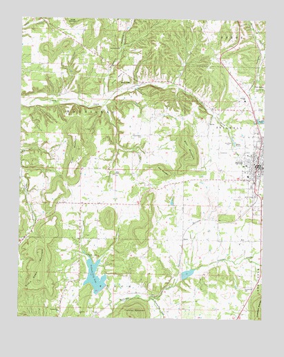
Stilwell West, OK USGS Topographic Map
Click on map above to begin viewing in our Map Viewer.

This topographic map contains these locations and features:
Feature Name Type Latitude Longitude GNIS ID View Map
Assembly of God ChurchChurchN35.8118°W94.6299°1810080View Map
BlanchPopulated PlaceN35.7831°W94.6661°1100215View Map
Calvary Southern Baptist ChurchChurchN35.8248°W94.6291°1810081View Map
Cherokee Hills ChurchChurchN35.7529°W94.7294°1091240View Map
Cherry Tree ChurchChurchN35.7501°W94.6477°1091258View Map
City of StilwellCivilN35.8151°W94.6312°2411983View Map
Clear Spring CemeteryCemeteryN35.7761°W94.7121°1091443View Map
Coon MountainSummitN35.8204°W94.7213°1091663View Map
Doublehead CemeteryCemeteryN35.7632°W94.6340°1092158View Map
Echota ChurchChurchN35.8184°W94.7499°1092474View Map
First Baptist ChurchChurchN35.8123°W94.6363°1810082View Map
First United Methodist ChurchChurchN35.8148°W94.6299°1810083View Map
Gittin Down MountainSummitN35.7651°W94.7402°1093196View Map
Goat MountainSummitN35.8098°W94.6752°1093222View Map
Grace ChapelChurchN35.8104°W94.7016°1093281View Map
Hanging Dog CreekStreamN35.7581°W94.6830°1093510View Map
Highway 51 West Fire Department AnnexBuildingN35.8457°W94.7023°2657298View Map
Indian Capital Technology Center Stilwell CampusSchoolN35.8406°W94.6342°1790475View Map
Joyful Life ChurchChurchN35.8187°W94.6258°1810084View Map
LyonsPopulated PlaceN35.7512°W94.7111°1100600View Map
Lyons SwitchCivilN35.7793°W94.6934°2631127View Map
Lyons Switch Census Designated PlaceCensusN35.7794°W94.6934°2408155View Map
MariettaCivilN35.8480°W94.6528°2631129View Map
MariettaPopulated PlaceN35.8434°W94.6580°1853474View Map
Marietta Census Designated PlaceCensusN35.8480°W94.6528°2408177View Map
Maryetta Public SchoolsSchoolN35.8415°W94.6349°1095166View Map
MulberryCivilN35.8638°W94.6810°2631136View Map
Mulberry Census Designated PlaceCensusN35.8631°W94.7013°2584385View Map
Mulberry HollowValleyN35.8434°W94.7069°1095693View Map
Mulberry Tree CemeteryCemeteryN35.8625°W94.6997°2724207View Map
Mulberry Tree ChurchChurchN35.8629°W94.7002°1095695View Map
Pafford Emergency Medical ServicesBuildingN35.8109°W94.6272°2695952View Map
Pentecostal Holiness ChurchChurchN35.8162°W94.6333°1810085View Map
Pilgrims Rest CemeteryCemeteryN35.8259°W94.6880°1096640View Map
Sallisaw Creek Site 18 DamDamN35.7634°W94.7052°1757929View Map
Sallisaw Creek Site 19 DamDamN35.7684°W94.6652°1757931View Map
Sallisaw Creek Site 19 ReservoirReservoirN35.7684°W94.6652°1757932View Map
Sequoyah ChurchChurchN35.7523°W94.7186°1097920View Map
StilwellPopulated PlaceN35.8145°W94.6286°1098544View Map
Stilwell Airport (historical)AirportN35.8376°W94.6252°1102679View Map
Stilwell City CemeteryCemeteryN35.8223°W94.6438°1095808View Map
Stilwell City LakeReservoirN35.7672°W94.7108°1098545View Map
Stilwell Elementary SchoolSchoolN35.8149°W94.6338°1819368View Map
Stilwell Fire DepartmentBuildingN35.8110°W94.6272°2656983View Map
Stilwell High SchoolSchoolN35.8103°W94.6469°1819366View Map
Stilwell Memorial HospitalHospitalN35.8093°W94.6432°2695794View Map
Stilwell Middle SchoolSchoolN35.8162°W94.6346°1819367View Map
Stilwell ParkParkN35.8331°W94.6269°1098546View Map
Stilwell Police DepartmentBuildingN35.8137°W94.6282°2757466View Map
Stilwell West DivisionCivilN35.8028°W94.7298°1937881View Map
Stilwell/Cherokee Nation Airport (historical)AirportN35.7556°W94.6485°1102133View Map
Stony PointPopulated PlaceN35.8479°W94.6947°1100857View Map
Stony PointCliffN35.8479°W94.7055°1098563View Map
Tyler SpringSpringN35.8473°W94.6305°1099131View Map
Tyler Spring CemeteryCemeteryN35.8462°W94.6299°1099132View Map
West MountainSummitN35.8176°W94.6624°1099585View Map
ZionPopulated PlaceN35.7826°W94.6349°1100959View Map
ZionCivilN35.7853°W94.6378°2631206View Map
Zion CemeteryCemeteryN35.7819°W94.6375°2712409View Map
Zion Census Designated PlaceCensusN35.7853°W94.6378°2409647View Map
Zion ChurchChurchN35.7829°W94.6480°1100081View Map
Zion Elementary SchoolSchoolN35.7817°W94.6369°1790732View Map

Note: Coordinates in the location and feature list above are referenced to NAD83 datum.


Copyright (C) 2008-2024 Ryan Niemi / Sunset Dynamics ... All Rights Reserved