TopoQuest Logo
Do you find TopoQuest useful?
Help keep TopoQuest running and adding new maps/features by donating!
Bitcoin:  19c7KJd3qBynnjoSw5npx9KScwjBe4ifkT
Litecoin:  LXs6TkuXGGXo1vDsWCkWVdjQX94eUKd6ui
Home View Maps Find Maps Find Places Resources & Links


Benson, Vermont Topographic Map

USGS Map Title: Benson, VT
USGS Map MRC: 43073F3
DRG (GeoTIFF) Download: o43073f3.tif


Neighboring USGS Topographic Map Quads:


  Ticonderoga, NY  
43073G4
 

  Orwell, VT  
43073G3
 

  Sudbury, VT  
43073G2
 

  Putnam, NY  
43073F4
 

  Benson, VT  
43073F3
 

  Bomoseen, VT  
43073F2
 

  Whitehall, NY  
43073E4
 

  Thorn Hill, NY  
43073E3
 

  Poultney, VT  
43073E2


Map MRC Location:

N44°
W74°
N44°
W73°
H8 H7 H6 H5 H4 H3 H2 H1
G8 G7 G6 G5 G4 G3 G2 G1
F8 F7 F6 F5 F4 F3 F2 F1
E8 E7 E6 E5 E4 E3 E2 E1
D8 D7 D6 D5 D4 D3 D2 D1
C8 C7 C6 C5 C4 C3 C2 C1
B8 B7 B6 B5 B4 B3 B2 B1
A8 A7 A6 A5 A4 A3 A2 A1
N43°
W74°
N43°
W73°

Benson, VT USGS 1:24K Topographic Map Preview:
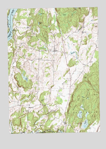
Benson, VT USGS Topographic Map
Click on map above to begin viewing in our Map Viewer.

This topographic map contains these locations and features:
Feature Name Type Latitude Longitude GNIS ID View Map
Aiken SchoolSchoolN43.6990°W73.3323°1456115View Map
Beaver MeadowSwampN43.6488°W73.2720°1456343View Map
BensonPopulated PlaceN43.7070°W73.3112°1456394View Map
Benson Census Designated PlaceCensusN43.7072°W73.3094°2586619View Map
Benson Fire DepartmentBuildingN43.7073°W73.3101°2121286View Map
Benson First ResponseBuildingN43.7073°W73.3102°2578132View Map
Benson LandingPopulated PlaceN43.7284°W73.3676°1456396View Map
Benson Post OfficePost OfficeN43.7068°W73.3107°1921742View Map
Benson Town HallBuildingN43.7065°W73.3096°1921743View Map
Benson Village Historic DistrictParkN43.7070°W73.3098°1921744View Map
Benson Village SchoolSchoolN43.7069°W73.3023°1921745View Map
Bullhead PondLakeN43.7347°W73.3312°1456643View Map
Bump SchoolSchoolN43.6951°W73.2626°1456646View Map
Carter Street CemeteryCemeteryN43.7148°W73.3565°1456780View Map
Carver Falls CemeteryCemeteryN43.6264°W73.3004°1456781View Map
Carver Falls DamDamN43.6273°W73.3065°945935View Map
Carver Falls DamDamN43.6273°W73.3065°1456782View Map
Center CemeteryCemeteryN43.6530°W73.3468°1456813View Map
Center SchoolSchoolN43.6473°W73.3476°1456823View Map
Claycreek FarmLocaleN43.6642°W73.2922°2680832View Map
Cobble KnollSummitN43.6798°W73.2690°1456945View Map
Coggman CreekStreamN43.6251°W73.3707°1456953View Map
Coons DenSummitN43.6628°W73.2579°1457013View Map
Cranberry SwampSwampN43.7431°W73.2959°1457048View Map
Fair Haven Municipal ForestForestN43.6542°W73.2626°1921869View Map
Fair View CemeteryCemeteryN43.7071°W73.3161°1457389View Map
Forbes HillSummitN43.6578°W73.3293°1457470View Map
Hackett Dam CemeteryCemeteryN43.6329°W73.3328°1457678View Map
Hitchcock CemeteryCemeteryN43.6530°W73.3239°1457844View Map
Howard DamDamN43.6603°W73.2721°1457913View Map
Howard HillSummitN43.7306°W73.2521°1457914View Map
Howard Hill SchoolSchoolN43.7256°W73.2709°1457915View Map
Howard PondReservoirN43.6608°W73.2725°1921927View Map
Hubbardton RiverStreamN43.6265°W73.3434°1457928View Map
Inman PondReservoirN43.6429°W73.2771°1457968View Map
Inman Pond DamDamN43.6467°W73.2762°1766583View Map
Mill PondLakeN43.7051°W73.2841°1458468View Map
Mount HamiltonSummitN43.6342°W73.2782°1457706View Map
Mud PondLakeN43.7440°W73.3292°1458608View Map
Old CemeteryCemeteryN43.7089°W73.3084°1922220View Map
Old Marsh PondReservoirN43.6329°W73.2700°1458827View Map
Old Marsh Pond DamDamN43.6334°W73.2701°1766549View Map
Parsons Mill DamDamN43.6984°W73.2796°1766489View Map
Pond Woods Wildlife Management AreaParkN43.7426°W73.2918°1922046View Map
Porcupine RidgeRidgeN43.6351°W73.2609°1459045View Map
Poultney RiverStreamN43.6265°W73.3434°961061View Map
Putnam StationPopulated PlaceN43.7342°W73.3748°972980View Map
Rattlesnake RidgeRidgeN43.6548°W73.2804°1459146View Map
Root PondLakeN43.6792°W73.3493°1459245View Map
Shaw MountainSummitN43.6809°W73.3637°1459467View Map
Sheldon DamDamN43.6592°W73.2668°1459483View Map
Sheldon PondReservoirN43.6589°W73.2660°1922119View Map
Sledge Length RidgeRidgeN43.6637°W73.2651°1459532View Map
Stony PointCapeN43.7437°W73.3662°1459741View Map
Stony Point SchoolSchoolN43.7309°W73.3476°1459743View Map
Strong SwampLakeN43.7103°W73.3232°1459756View Map
Sucker CreekStreamN43.6445°W73.2671°1459765View Map
The Great LedgeCliffN43.6553°W73.2891°1459859View Map
Town of BensonCivilN43.7122°W73.3082°1462040View Map
Town of West HavenCivilN43.6345°W73.3687°1462252View Map
Turnpike SchoolSchoolN43.6342°W73.2959°1459969View Map
Walker SwampSwampN43.7445°W73.2837°1460049View Map
West HavenPopulated PlaceN43.6515°W73.3473°1460145View Map
West Haven Volunteer Fire DepartmentBuildingN43.6524°W73.3467°2121263View Map
Wilcox HillSummitN43.7215°W73.3457°1460248View Map

Note: Coordinates in the location and feature list above are referenced to NAD83 datum.


Copyright (C) 2008-2024 Ryan Niemi / Sunset Dynamics ... All Rights Reserved