TopoQuest Logo
Do you find TopoQuest useful?
Help keep TopoQuest running and adding new maps/features by donating!
Bitcoin:  19c7KJd3qBynnjoSw5npx9KScwjBe4ifkT
Litecoin:  LXs6TkuXGGXo1vDsWCkWVdjQX94eUKd6ui
Home View Maps Find Maps Find Places Resources & Links


Whitehall, New York Topographic Map

USGS Map Title: Whitehall, NY
USGS Map MRC: 43073E4
DRG (GeoTIFF) Download: o43073e4.tif


Neighboring USGS Topographic Map Quads:


  Silver Bay, NY  
43073F5
 

  Putnam, NY  
43073F4
 

  Benson, VT  
43073F3
 

  Shelving Rock, NY  
43073E5
 

  Whitehall, NY  
43073E4
 

  Thorn Hill, NY  
43073E3
 

  Putnam Mountain, NY  
43073D5
 

  Fort Ann, NY  
43073D4
 

  Granville, NY  
43073D3


Map MRC Location:

N44°
W74°
N44°
W73°
H8 H7 H6 H5 H4 H3 H2 H1
G8 G7 G6 G5 G4 G3 G2 G1
F8 F7 F6 F5 F4 F3 F2 F1
E8 E7 E6 E5 E4 E3 E2 E1
D8 D7 D6 D5 D4 D3 D2 D1
C8 C7 C6 C5 C4 C3 C2 C1
B8 B7 B6 B5 B4 B3 B2 B1
A8 A7 A6 A5 A4 A3 A2 A1
N43°
W74°
N43°
W73°

Whitehall, NY USGS 1:24K Topographic Map Preview:
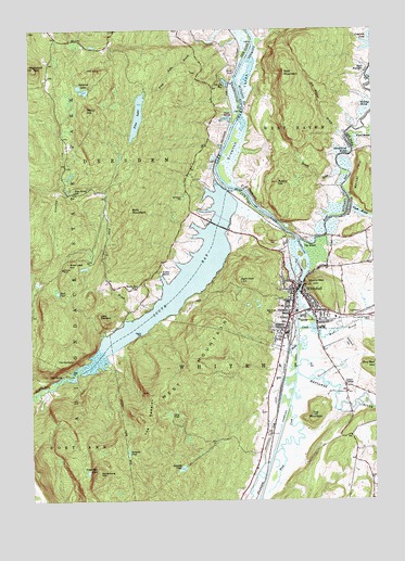
Whitehall, NY USGS Topographic Map
Click on map above to begin viewing in our Map Viewer.

This topographic map contains these locations and features:
Feature Name Type Latitude Longitude GNIS ID View Map
Adams - Elbow CemeteryCemeteryN43.5689°W73.3999°1921724View Map
Austin HillSummitN43.5845°W73.4087°1456187View Map
Bald MountainSummitN43.5765°W73.4629°942870View Map
Bald MountainSummitN43.6128°W73.4059°1456228View Map
Berry HillSummitN43.6037°W73.4787°943748View Map
Big Hollow BrookStreamN43.5978°W73.3868°1456414View Map
Billings MarshLakeN43.6047°W73.3775°1456424View Map
Black Lead HillSummitN43.5628°W73.4859°944141View Map
Boardman CemeteryCemeteryN43.5494°W73.4102°944370View Map
Bumps BrookStreamN43.5856°W73.3893°1456647View Map
Capitol Theatre (historical)BuildingN43.5556°W73.4028°2499922View Map
Cat Den BayLakeN43.6108°W73.4280°946008View Map
Central High School (historical)SchoolN43.5525°W73.4058°2499932View Map
Champlain Canal BridgeBridgeN43.5496°W73.4020°2599513View Map
Church of Our Lady of the AngelsChurchN43.5494°W73.4050°2499933View Map
Clear PondLakeN43.5227°W73.4496°946821View Map
Coggman PondLakeN43.6210°W73.3750°1456954View Map
Cold SpringSpringN43.5331°W73.4882°947057View Map
Death RockPillarN43.5581°W73.4232°948150View Map
Devils PulpitPillarN43.5501°W73.3996°973333View Map
Drowned LandsSwampN43.5990°W73.4201°1457194View Map
Duso MarshSwampN43.6015°W73.4276°948844View Map
East BayGutN43.5859°W73.3826°948976View Map
East BayBayN43.6009°W73.3771°1457250View Map
First Baptist ChurchChurchN43.5528°W73.3986°2499931View Map
First Presbyterian ChurchChurchN43.5558°W73.4036°2499924View Map
Grace Baptist ChurchChurchN43.5499°W73.4063°2598351View Map
Grays CornerPopulated PlaceN43.5303°W73.3854°972560View Map
Greenland BrookStreamN43.5284°W73.4979°951750View Map
Greenmount CemeteryCemeteryN43.5412°W73.3838°951755View Map
Head of Lake ChamplainLocaleN43.5762°W73.4148°952479View Map
Hooper MineMineN43.5615°W73.4879°953166View Map
Isaac C Griswold LibraryBuildingN43.5542°W73.4008°2499929View Map
Little DiameterSummitN43.5492°W73.4748°955514View Map
Lock TwelveDamN43.5573°W73.4009°973723View Map
Lock Twelve MarinaLocaleN43.5576°W73.3996°973719View Map
Main Street Historic DistrictParkN43.5556°W73.4033°2500689View Map
Mettawee RiverStreamN43.5340°W73.4029°957044View Map
Mud BrookStreamN43.5456°W73.3971°957986View Map
Mud PondLakeN43.5553°W73.4899°958075View Map
Neddo CemeteryCemeteryN43.5660°W73.4085°2499938View Map
New Arlington Hotel (historical)BuildingN43.5486°W73.4056°2499934View Map
Ore Bed HillSummitN43.5348°W73.3757°959452View Map
Our Lady of Hope ChurchChurchN43.5517°W73.3969°2499935View Map
Pike BrookStreamN43.5490°W73.4640°960385View Map
Pike Brook SchoolSchoolN43.5820°W73.4834°960386View Map
Pine LakeLakeN43.6021°W73.4599°960499View Map
Pine Lake BrookStreamN43.6215°W73.4351°960503View Map
Riverside ParkParkN43.5547°W73.4022°2499927View Map
Rodd - Elbow CemeteryCemeteryN43.5683°W73.4104°2499937View Map
Sawmill PondLakeN43.5085°W73.4450°964533View Map
Schoolhouse MarshLakeN43.5930°W73.3876°1459428View Map
Sheltered LakesLakeN43.6087°W73.4789°965041View Map
Skene MountainSummitN43.5570°W73.3968°965347View Map
Skene Valley Country ClubLocaleN43.5558°W73.3814°2499799View Map
Skenesborough Emergency SquadBuildingN43.5516°W73.4032°2720219View Map
Snody DockLocaleN43.6137°W73.4254°965575View Map
South BayBayN43.5573°W73.4432°965668View Map
South Bay CausewayBridgeN43.5728°W73.4311°2499802View Map
South Bay CreekStreamN43.5340°W73.4815°965677View Map
South Bay QuarryMineN43.5722°W73.4733°2564198View Map
South Bay SchoolSchoolN43.5562°W73.4612°965679View Map
Spectacle PondLakeN43.5126°W73.4649°965965View Map
Sugarloaf MountainSummitN43.6145°W73.4976°970684View Map
The DiameterSummitN43.5376°W73.4846°967231View Map
The ElbowBendN43.5678°W73.3979°967233View Map
The KnobSummitN43.6140°W73.4737°967277View Map
The SaddlesSummitN43.5212°W73.4571°967335View Map
Timber MarshSwampN43.5601°W73.4523°967533View Map
Town of DresdenCivilN43.6147°W73.4786°978907View Map
Town of WhitehallCivilN43.5367°W73.3805°979636View Map
Town of Whitehall OfficesBuildingN43.5550°W73.4028°2499925View Map
Trinity Episcopal ChurchChurchN43.5544°W73.4039°2499928View Map
Tub MountainSummitN43.5223°W73.3976°967921View Map
Valley View Golf CourseLocaleN43.5363°W73.3845°2599525View Map
Vanderburg MountainSummitN43.5070°W73.4754°968455View Map
Vanderburg PondLakeN43.5074°W73.4794°968456View Map
Village of WhitehallCivilN43.5550°W73.4222°2391215View Map
Ward MarshSwampN43.5967°W73.3784°968786View Map
Ward Marsh Wildlife Management AreaParkN43.5987°W73.3837°1922180View Map
Warner HillSummitN43.5873°W73.3793°968806View Map
West MountainSummitN43.5270°W73.4526°970810View Map
WhitehallPopulated PlaceN43.5556°W73.4037°971145View Map
Whitehall ArmoryMilitaryN43.5494°W73.3961°2500694View Map
Whitehall Free LibraryBuildingN43.5540°W73.4001°2599534View Map
Whitehall Junior-Senior High SchoolSchoolN43.5519°W73.3753°2499800View Map
Whitehall MarinaLocaleN43.5592°W73.4010°2599536View Map
Whitehall Mobile Home ParkPopulated PlaceN43.5372°W73.4089°2500223View Map
Whitehall Police DepartmentBuildingN43.5536°W73.4031°2780739View Map
Whitehall Post OfficePost OfficeN43.5537°W73.4039°2598344View Map
Whitehall ReservoirReservoirN43.5805°W73.4436°971147View Map
Whitehall United Methodist ChurchChurchN43.5403°W73.3887°2598361View Map
Whitehall Village OfficeBuildingN43.5550°W73.4011°2499923View Map
Whitehall Volunteer Fire CompanyBuildingN43.5543°W73.4026°2499926View Map
Williams Street CemeteryCemeteryN43.5491°W73.3952°2499936View Map
Williams Street School (historical)SchoolN43.5539°W73.4003°2499930View Map
Wood CreekGutN43.5165°W73.4059°971597View Map
Wood CreekGutN43.5434°W73.4029°971598View Map

Note: Coordinates in the location and feature list above are referenced to NAD83 datum.


Copyright (C) 2008-2025 Ryan Niemi / Sunset Dynamics ... All Rights Reserved