TopoQuest Logo
Do you find TopoQuest useful?
Help keep TopoQuest running and adding new maps/features by donating!
Bitcoin:  19c7KJd3qBynnjoSw5npx9KScwjBe4ifkT
Litecoin:  LXs6TkuXGGXo1vDsWCkWVdjQX94eUKd6ui
Home View Maps Find Maps Find Places Resources & Links


Orwell, Vermont Topographic Map

USGS Map Title: Orwell, VT
USGS Map MRC: 43073G3
DRG (GeoTIFF) Download: o43073g3.tif


Neighboring USGS Topographic Map Quads:


  Crown Point, NY  
43073H4
 

  Bridport, VT  
43073H3
 

  Cornwall, VT  
43073H2
 

  Ticonderoga, NY  
43073G4
 

  Orwell, VT  
43073G3
 

  Sudbury, VT  
43073G2
 

  Putnam, NY  
43073F4
 

  Benson, VT  
43073F3
 

  Bomoseen, VT  
43073F2


Map MRC Location:

N44°
W74°
N44°
W73°
H8 H7 H6 H5 H4 H3 H2 H1
G8 G7 G6 G5 G4 G3 G2 G1
F8 F7 F6 F5 F4 F3 F2 F1
E8 E7 E6 E5 E4 E3 E2 E1
D8 D7 D6 D5 D4 D3 D2 D1
C8 C7 C6 C5 C4 C3 C2 C1
B8 B7 B6 B5 B4 B3 B2 B1
A8 A7 A6 A5 A4 A3 A2 A1
N43°
W74°
N43°
W73°

Orwell, VT USGS 1:24K Topographic Map Preview:
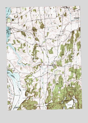
Orwell, VT USGS Topographic Map
Click on map above to begin viewing in our Map Viewer.

This topographic map contains these locations and features:
Feature Name Type Latitude Longitude GNIS ID View Map
Allen BayBayN43.7845°W73.3529°1456141View Map
Arnolds LedgeCliffN43.7537°W73.2559°1456175View Map
Barnum HillSummitN43.8570°W73.3185°1456270View Map
Barnum Hill SchoolSchoolN43.8589°W73.3182°1456271View Map
Beadles CoveBayN43.8509°W73.3707°1456303View Map
Beemans Corners (historical)LocaleN43.8037°W73.3057°1918031View Map
Benson BayBayN43.7653°W73.3457°1456395View Map
Big BrookStreamN43.7742°W73.3429°1456410View Map
Bishop HillSummitN43.7623°W73.2882°1456434View Map
Blue LedgeCliffN43.7692°W73.3440°1456488View Map
Blueberry HillSummitN43.7809°W73.2901°1456496View Map
Camp SunriseLocaleN43.7581°W73.2637°1456755View Map
Chipman Point MarinaLocaleN43.8001°W73.3735°1460484View Map
Choate PondLakeN43.7789°W73.2686°1456885View Map
Conkey HillSummitN43.7956°W73.2679°1456995View Map
Conway SwampSwampN43.7823°W73.2832°1456999View Map
Cutting HillSummitN43.8712°W73.2587°1457085View Map
Daigneau HillSummitN43.8140°W73.2787°1457088View Map
Doughty HillSummitN43.7537°W73.3315°1457186View Map
Doughty PondLakeN43.7585°W73.2829°1457187View Map
East Creek Site 1 DamDamN43.8017°W73.3179°1766514View Map
East Creek Site 2 DamDamN43.7917°W73.3146°1766515View Map
East Creek Waterfowl AreaParkN43.8070°W73.3496°1918082View Map
East ShorehamPopulated PlaceN43.8603°W73.2529°1457321View Map
East Shoreham CemeteryCemeteryN43.8687°W73.2582°1457322View Map
East Shoreham Covered Railroad BridgeBridgeN43.8592°W73.2559°1918087View Map
Gourlie PointCapeN43.7959°W73.3737°951424View Map
Hack CemeteryCemeteryN43.8366°W73.2501°1918114View Map
Hands CoveBayN43.8620°W73.3732°1457714View Map
Hardigan HillSummitN43.8473°W73.3273°1457722View Map
Hibbard HillSummitN43.8142°W73.2632°1457810View Map
Hough CrossingPopulated PlaceN43.8264°W73.3176°1460425View Map
Hough Crossing SchoolSchoolN43.8295°W73.3318°1457904View Map
Hutton HillSummitN43.7592°W73.3740°953551View Map
Jennison CemeteryCemeteryN43.8742°W73.3337°1918127View Map
Jones BrookStreamN43.8328°W73.3082°1458032View Map
Lakeview CemeteryCemeteryN43.7983°W73.3626°1458148View Map
Lapell CemeteryCemeteryN43.8635°W73.2799°1458163View Map
Larrabees Point StationLocaleN43.8489°W73.3671°1458169View Map
Mountain View CemeteryCemeteryN43.8041°W73.2678°1458591View Map
Mud DockLocaleN43.7953°W73.3573°1458601View Map
Mud PondLakeN43.7655°W73.2697°1458609View Map
Murray HillSummitN43.8459°W73.2507°1458644View Map
Needham HillSummitN43.7765°W73.2968°1458659View Map
Negro MarshSwampN43.7784°W73.3732°958584View Map
North CemeteryCemeteryN43.8084°W73.2949°1458717View Map
North Fork East CreekStreamN43.8042°W73.3365°1458732View Map
North OrwellLocaleN43.8398°W73.2848°1458750View Map
Oak HillSummitN43.7570°W73.2873°1458807View Map
OrwellPopulated PlaceN43.8040°W73.2979°1458855View Map
Orwell Bluff LightLocaleN43.7778°W73.3496°1460483View Map
Orwell LandingLocaleN43.7942°W73.3732°1460485View Map
Orwell Post OfficePost OfficeN43.8041°W73.2969°1918193View Map
Orwell Village SchoolSchoolN43.8044°W73.2991°1918194View Map
Orwell Volunteer Fire DepartmentBuildingN43.8038°W73.2916°2121346View Map
Pepper BrookStreamN43.8356°W73.3076°1458937View Map
Perch PondLakeN43.7512°W73.2799°1458938View Map
Peter Hall CemeteryCemeteryN43.7924°W73.2862°1918200View Map
Pond Woods Wildlife Management AreaParkN43.7703°W73.2709°1918202View Map
Rich Family CemeteryCemeteryN43.8695°W73.2758°1918209View Map
RichvillePopulated PlaceN43.8739°W73.2718°1460449View Map
Royce BrookStreamN43.8273°W73.3168°1459279View Map
Saint Pauls CemeteryCemeteryN43.8156°W73.2748°1459342View Map
Sanford BrookStreamN43.7823°W73.3151°1459371View Map
Shoreham Center SchoolSchoolN43.8734°W73.2726°1459500View Map
Sixmile PointCapeN43.7681°W73.3615°965329View Map
Smith SchoolSchoolN43.8437°W73.2648°1459545View Map
South Fork East CreekStreamN43.7995°W73.3109°1459584View Map
Spruce PondLakeN43.7629°W73.2779°1459657View Map
Stacy BrookStreamN43.7590°W73.3148°1459663View Map
Stacy CrossroadsPopulated PlaceN43.7551°W73.3096°1460460View Map
Stevens BayBayN43.7753°W73.3454°1459698View Map
Sunrise LakeReservoirN43.7603°W73.2604°1459784View Map
Sunrise Lake DamDamN43.7606°W73.2601°1766477View Map
Sunset LakeLakeN43.7559°W73.2702°1459790View Map
The PinnaclePillarN43.7740°W73.2671°1459888View Map
Town of OrwellCivilN43.8062°W73.2932°1462168View Map
White LedgeCliffN43.7642°W73.3376°1460223View Map

Note: Coordinates in the location and feature list above are referenced to NAD83 datum.


Copyright (C) 2008-2024 Ryan Niemi / Sunset Dynamics ... All Rights Reserved