TopoQuest Logo
Do you find TopoQuest useful?
Help keep TopoQuest running and adding new maps/features by donating!
Bitcoin:  19c7KJd3qBynnjoSw5npx9KScwjBe4ifkT
Litecoin:  LXs6TkuXGGXo1vDsWCkWVdjQX94eUKd6ui
Home View Maps Find Maps Find Places Resources & Links


Pyatt, Arkansas Topographic Map

USGS Map Title: Pyatt, AR
USGS Map MRC: 36092C7
DRG (GeoTIFF) Download: o36092c7.tif


Neighboring USGS Topographic Map Quads:


  Diamond City, AR  
36092D8
 

  Peel, AR  
36092D7
 

  Cotter NW, AR  
36092D6
 

  Zinc, AR  
36092C8
 

  Pyatt, AR  
36092C7
 

  Cotter SW, AR  
36092C6
 

  Everton, AR  
36092B8
 

  Bruno, AR  
36092B7
 

  Yellville, AR  
36092B6


Map MRC Location:

N37°
W93°
N37°
W92°
H8 H7 H6 H5 H4 H3 H2 H1
G8 G7 G6 G5 G4 G3 G2 G1
F8 F7 F6 F5 F4 F3 F2 F1
E8 E7 E6 E5 E4 E3 E2 E1
D8 D7 D6 D5 D4 D3 D2 D1
C8 C7 C6 C5 C4 C3 C2 C1
B8 B7 B6 B5 B4 B3 B2 B1
A8 A7 A6 A5 A4 A3 A2 A1
N36°
W93°
N36°
W92°

Pyatt, AR USGS 1:24K Topographic Map Preview:
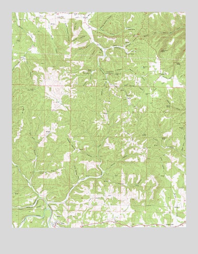
Pyatt, AR USGS Topographic Map
Click on map above to begin viewing in our Map Viewer.

This topographic map contains these locations and features:
Feature Name Type Latitude Longitude GNIS ID View Map
Angel Springs HollowValleyN36.3312°W92.7960°45872View Map
Bear Hill HollowValleyN36.2923°W92.7529°46221View Map
Bear Hill MineMineN36.3076°W92.7516°46222View Map
Boozer HollowValleyN36.3637°W92.7702°46843View Map
Cave HollowValleyN36.2795°W92.7649°47546View Map
Chapman HollowValleyN36.3542°W92.8116°47702View Map
Chapman SpringSpringN36.3515°W92.7932°47703View Map
Clark HillSummitN36.3301°W92.8591°61069View Map
Coon SpringSpringN36.3042°W92.7791°48004View Map
Copperhead MineMineN36.3406°W92.8082°48037View Map
Derryberry CemeteryCemeteryN36.3709°W92.8707°48482View Map
Dodd CityPopulated PlaceN36.3273°W92.7929°76805View Map
Dodd City CemeteryCemeteryN36.3265°W92.7782°48544View Map
Dodd City School (historical)SchoolN36.3295°W92.7932°81920View Map
Flat Hollow BranchStreamN36.3653°W92.8221°49109View Map
Fox HollowValleyN36.3556°W92.8141°49212View Map
Georges CreekPopulated PlaceN36.2509°W92.7616°57809View Map
Gravelly HollowValleyN36.3551°W92.7977°49595View Map
Green Campbell HollowValleyN36.3715°W92.8379°49625View Map
Grever SpringSpringN36.3459°W92.7566°49673View Map
Iola HollowValleyN36.3501°W92.8660°50516View Map
Jaybird CemeteryCemeteryN36.3587°W92.8693°50598View Map
Keesee CemeteryCemeteryN36.3748°W92.8302°50783View Map
Keesee School (historical)SchoolN36.3748°W92.8307°85275View Map
LakewayPopulated PlaceN36.3387°W92.7685°57084View Map
Lakeway Rural Volunteer Fire Station 1BuildingN36.3321°W92.7744°2116694View Map
Lakeway Rural Volunteer Fire Substation 2BuildingN36.3645°W92.8569°2116695View Map
Lakeway Volunteer Fire Department SubstationBuildingN36.3367°W92.8655°2116696View Map
Lead Mine CreekStreamN36.3720°W92.8254°51027View Map
Leon HollowValleyN36.3578°W92.8160°51066View Map
Linton RidgeRidgeN36.3206°W92.8668°51175View Map
Little Sugar CreekStreamN36.2640°W92.8499°51330View Map
London Spring HollowValleyN36.2915°W92.8132°51392View Map
Marble Falls SpringSpringN36.3523°W92.7679°51663View Map
Markle HollowValleyN36.3445°W92.8132°51673View Map
Markle MineMineN36.3395°W92.8188°51674View Map
Markle SpringSpringN36.3403°W92.8185°51675View Map
Martin HollowValleyN36.2817°W92.8104°51713View Map
Mining House HollowValleyN36.3651°W92.8124°52091View Map
Morris SpringSpringN36.3203°W92.7613°52221View Map
Nokomis HollowValleyN36.3356°W92.8063°52789View Map
Pannell HollowValleyN36.2790°W92.8118°53144View Map
Parks HollowValleyN36.3706°W92.8291°53196View Map
Pig Pen HollowValleyN36.3628°W92.8199°53357View Map
Pigeon Roost BranchStreamN36.3390°W92.8085°53363View Map
Pigeon Roost MineMineN36.3390°W92.8010°53367View Map
Pilot Rock MineMineN36.3395°W92.8077°53400View Map
Pine FlatFlatN36.3331°W92.7688°53419View Map
Pyatt Rural Fire and Defense AssociationBuildingN36.2636°W92.8443°2117006View Map
Sailor SpringSpringN36.3653°W92.7921°54306View Map
Salina HollowValleyN36.3717°W92.8513°54507View Map
Sand Spring HollowValleyN36.2753°W92.8285°54546View Map
SnowPopulated PlaceN36.2528°W92.8021°58651View Map
Sugar Orchard CreekStreamN36.2609°W92.8504°55309View Map
Sycamore SpringSpringN36.3023°W92.7677°55411View Map
Tallow Clay HollowValleyN36.3501°W92.8660°55420View Map
Tar Kiln BranchStreamN36.2767°W92.8632°78525View Map
Tar Kiln CreekStreamN36.2676°W92.8552°55432View Map
Tar Kiln Lookout TowerTowerN36.3301°W92.8588°82564View Map
Town of PyattCivilN36.2510°W92.8441°2407167View Map
Township of Blythe (historical)CivilN36.2626°W92.8418°69627View Map
Township of Dodd City (historical)CivilN36.3237°W92.7793°69633View Map
Township of Joe Burleson (historical)CivilN36.2556°W92.7516°69639View Map
Township of North Joe Burleson (historical)CivilN36.2697°W92.7563°2406964View Map
Township of Sugarloaf (historical)CivilN36.3695°W92.8502°69645View Map
Waltman PondLakeN36.3431°W92.7816°75879View Map

Note: Coordinates in the location and feature list above are referenced to NAD83 datum.


Copyright (C) 2008-2024 Ryan Niemi / Sunset Dynamics ... All Rights Reserved