TopoQuest Logo
Do you find TopoQuest useful?
Help keep TopoQuest running and adding new maps/features by donating!
Bitcoin:  19c7KJd3qBynnjoSw5npx9KScwjBe4ifkT
Litecoin:  LXs6TkuXGGXo1vDsWCkWVdjQX94eUKd6ui
Home View Maps Find Maps Find Places Resources & Links


Bruno, Arkansas Topographic Map

USGS Map Title: Bruno, AR
USGS Map MRC: 36092B7
DRG (GeoTIFF) Download: o36092b7.tif


Neighboring USGS Topographic Map Quads:


  Zinc, AR  
36092C8
 

  Pyatt, AR  
36092C7
 

  Cotter SW, AR  
36092C6
 

  Everton, AR  
36092B8
 

  Bruno, AR  
36092B7
 

  Yellville, AR  
36092B6
 

  Western Grove, AR  
36092A8
 

  Saint Joe, AR  
36092A7
 

  Maumee, AR  
36092A6


Map MRC Location:

N37°
W93°
N37°
W92°
H8 H7 H6 H5 H4 H3 H2 H1
G8 G7 G6 G5 G4 G3 G2 G1
F8 F7 F6 F5 F4 F3 F2 F1
E8 E7 E6 E5 E4 E3 E2 E1
D8 D7 D6 D5 D4 D3 D2 D1
C8 C7 C6 C5 C4 C3 C2 C1
B8 B7 B6 B5 B4 B3 B2 B1
A8 A7 A6 A5 A4 A3 A2 A1
N36°
W93°
N36°
W92°

Bruno, AR USGS 1:24K Topographic Map Preview:
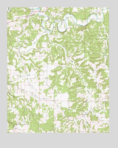
Bruno, AR USGS Topographic Map
Click on map above to begin viewing in our Map Viewer.

This topographic map contains these locations and features:
Feature Name Type Latitude Longitude GNIS ID View Map
BrunoPopulated PlaceN36.1442°W92.7782°76437View Map
Bruno - Pyatt Elementary SchoolSchoolN36.1808°W92.8497°2039023View Map
Bruno Baptist ChurchChurchN36.1440°W92.7777°61098View Map
Bruno CemeteryCemeteryN36.1556°W92.7765°47036View Map
Bruno Post OfficePost OfficeN36.1440°W92.7774°83977View Map
Bruno School (historical)SchoolN36.1423°W92.7813°61096View Map
Bruno Volunteer Fire Protection DistrictBuildingN36.1441°W92.7782°2116195View Map
Bruno-Pyatt High SchoolSchoolN36.2132°W92.8628°2039024View Map
Clear CreekStreamN36.2265°W92.8232°47833View Map
ComalPopulated PlaceN36.2373°W92.7724°76656View Map
East Fork Hampton CreekStreamN36.1506°W92.7752°61099View Map
Ebbing SpringsSpringN36.1431°W92.7824°61097View Map
ErosPopulated PlaceN36.1834°W92.8507°48913View Map
Eros School (historical)SchoolN36.1828°W92.8496°81923View Map
Greasy CreekStreamN36.2356°W92.7602°49620View Map
Hall CemeteryCemeteryN36.1937°W92.7985°77106View Map
Hampton CreekStreamN36.2262°W92.8207°49812View Map
Jefferson Hall School (historical)SchoolN36.1965°W92.7999°81924View Map
Kings PrairieFlatN36.1776°W92.8546°50870View Map
Ozark Mountain SpringSpringN36.2001°W92.7529°67188View Map
Parker HollowValleyN36.2177°W92.7548°53191View Map
Patton CemeteryCemeteryN36.2262°W92.8268°53227View Map
PowellPopulated PlaceN36.2376°W92.8168°58420View Map
PyattPopulated PlaceN36.2459°W92.8449°78119View Map
Pyatt Baptist ChurchChurchN36.2420°W92.8449°61065View Map
Pyatt Church of ChristChurchN36.2431°W92.8446°61091View Map
Pyatt Rural Volunteer Fire Department SubstationBuildingN36.2097°W92.8312°2117007View Map
Pyatt School (historical)SchoolN36.2434°W92.8454°61090View Map
Stanley CemeteryCemeteryN36.2037°W92.8621°55156View Map
Township of Prairie (historical)CivilN36.1806°W92.8363°69644View Map
Township of South Joe Burleson (historical)CivilN36.2356°W92.7596°2407399View Map
TurkeyPopulated PlaceN36.2445°W92.7638°57215View Map

Note: Coordinates in the location and feature list above are referenced to NAD83 datum.


Copyright (C) 2008-2024 Ryan Niemi / Sunset Dynamics ... All Rights Reserved