TopoQuest Logo
Do you find TopoQuest useful?
Help keep TopoQuest running and adding new maps/features by donating!
Bitcoin:  19c7KJd3qBynnjoSw5npx9KScwjBe4ifkT
Litecoin:  LXs6TkuXGGXo1vDsWCkWVdjQX94eUKd6ui
Home View Maps Find Maps Find Places Resources & Links


Cotter NW, Arkansas Topographic Map

USGS Map Title: Cotter NW, AR
USGS Map MRC: 36092D6
DRG (GeoTIFF) Download: o36092d6.tif


Neighboring USGS Topographic Map Quads:


  Protem, MO  
36092E7
 

  Theodosia, MO  
36092E6
 

  Isabella, MO  
36092E5
 

  Peel, AR  
36092D7
 

  Cotter NW, AR  
36092D6
 

  Bull Shoals, AR  
36092D5
 

  Pyatt, AR  
36092C7
 

  Cotter SW, AR  
36092C6
 

  Cotter, AR  
36092C5


Map MRC Location:

N37°
W93°
N37°
W92°
H8 H7 H6 H5 H4 H3 H2 H1
G8 G7 G6 G5 G4 G3 G2 G1
F8 F7 F6 F5 F4 F3 F2 F1
E8 E7 E6 E5 E4 E3 E2 E1
D8 D7 D6 D5 D4 D3 D2 D1
C8 C7 C6 C5 C4 C3 C2 C1
B8 B7 B6 B5 B4 B3 B2 B1
A8 A7 A6 A5 A4 A3 A2 A1
N36°
W93°
N36°
W92°

Cotter NW, AR USGS 1:24K Topographic Map Preview:
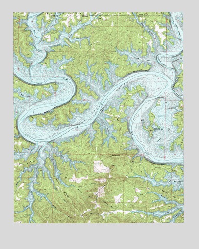
Cotter NW, AR USGS Topographic Map
Click on map above to begin viewing in our Map Viewer.

This topographic map contains these locations and features:
Feature Name Type Latitude Longitude GNIS ID View Map
Barnes BayBayN36.4262°W92.6391°46098View Map
Big Music CreekStreamN36.4234°W92.7263°76342View Map
Boren ForkStreamN36.4090°W92.7346°46844View Map
Buck Spring HollowValleyN36.3856°W92.6293°47138View Map
Bull Bottom BluffCliffN36.4420°W92.7227°47165View Map
Buzzard BluffCliffN36.4590°W92.6299°47245View Map
Cane Bottom BluffCliffN36.4642°W92.6629°47373View Map
Carver HollowValleyN36.3965°W92.7035°47503View Map
Cedar CreekStreamN36.4434°W92.6942°47586View Map
Cedar HollowValleyN36.4084°W92.7288°47619View Map
Coal Pit HollowValleyN36.3826°W92.6718°47870View Map
Coon CreekStreamN36.4237°W92.7324°48000View Map
Dark HollowValleyN36.4953°W92.6935°48360View Map
Dry Music CreekStreamN36.4170°W92.7229°48669View Map
Frost PointCapeN36.4048°W92.6288°49278View Map
Gulley Spring CreekStreamN36.4548°W92.6343°77085View Map
Hollingsworth CoveStreamN36.4698°W92.6349°50202View Map
Jones Point Wildlife Management AreaParkN36.4456°W92.7043°61044View Map
Keystone HollowValleyN36.3826°W92.6718°50833View Map
Little Cedar CreekStreamN36.4887°W92.7296°51219View Map
Little Fool CreekStreamN36.4465°W92.7407°51270View Map
Little Music CreekStreamN36.4206°W92.7254°51300View Map
Little North Fork White RiverStreamN36.4562°W92.6341°51301View Map
MidwayPopulated PlaceN36.4106°W92.6629°57117View Map
Oakland Public Use AreaParkN36.4440°W92.6304°52964View Map
Ozard Isle Public Use AreaParkN36.4328°W92.6493°53121View Map
Ozark IsleIslandN36.4353°W92.6479°61059View Map
Ozark Isle Public Use AreaParkN36.4306°W92.6488°61060View Map
Pine BranchPopulated PlaceN36.4751°W92.6969°2728553View Map
Pine BranchStreamN36.4762°W92.6424°751599View Map
Pine HollowValleyN36.4989°W92.6613°61051View Map
Pine MountainSummitN36.4145°W92.6779°53461View Map
Pine Mountain AirparkAirportN36.4152°W92.6895°2650776View Map
Pine Mountain Volunteer Fire DepartmentBuildingN36.4111°W92.6639°2116967View Map
Plum HollowValleyN36.4840°W92.7088°53629View Map
Pot Shoals CreekStreamN36.4381°W92.6885°53723View Map
Sister CreekStreamN36.3851°W92.6263°54877View Map
Stallion HollowValleyN36.3965°W92.7035°55147View Map
Stave Mill HollowValleyN36.3951°W92.7357°55182View Map
Tie Chute BluffCliffN36.4103°W92.6452°55569View Map
Tom HollowValleyN36.3853°W92.7385°55596View Map
Totty FieldAirportN36.4893°W92.6403°2650782View Map
Township of Cedar Creek (historical)CivilN36.4709°W92.6835°69629View Map
Township of Keeter (historical)CivilN36.3917°W92.7168°69641View Map
Wilkerson RidgeRidgeN36.3931°W92.7129°56381View Map
Wilson BluffCliffN36.4417°W92.6516°61061View Map
Windgate RidgeRidgeN36.3915°W92.6343°45768View Map
Yocum CoveStreamN36.4701°W92.6474°56602View Map

Note: Coordinates in the location and feature list above are referenced to NAD83 datum.


Copyright (C) 2008-2025 Ryan Niemi / Sunset Dynamics ... All Rights Reserved