TopoQuest Logo
Do you find TopoQuest useful?
Help keep TopoQuest running and adding new maps/features by donating!
Bitcoin:  19c7KJd3qBynnjoSw5npx9KScwjBe4ifkT
Litecoin:  LXs6TkuXGGXo1vDsWCkWVdjQX94eUKd6ui
Home View Maps Find Maps Find Places Resources & Links


Yellville, Arkansas Topographic Map

USGS Map Title: Yellville, AR
USGS Map MRC: 36092B6
DRG (GeoTIFF) Download: o36092b6.tif


Neighboring USGS Topographic Map Quads:


  Pyatt, AR  
36092C7
 

  Cotter SW, AR  
36092C6
 

  Cotter, AR  
36092C5
 

  Bruno, AR  
36092B7
 

  Yellville, AR  
36092B6
 

  Rea Valley, AR  
36092B5
 

  Saint Joe, AR  
36092A7
 

  Maumee, AR  
36092A6
 

  Cozahome, AR  
36092A5


Map MRC Location:

N37°
W93°
N37°
W92°
H8 H7 H6 H5 H4 H3 H2 H1
G8 G7 G6 G5 G4 G3 G2 G1
F8 F7 F6 F5 F4 F3 F2 F1
E8 E7 E6 E5 E4 E3 E2 E1
D8 D7 D6 D5 D4 D3 D2 D1
C8 C7 C6 C5 C4 C3 C2 C1
B8 B7 B6 B5 B4 B3 B2 B1
A8 A7 A6 A5 A4 A3 A2 A1
N36°
W93°
N36°
W92°

Yellville, AR USGS 1:24K Topographic Map Preview:
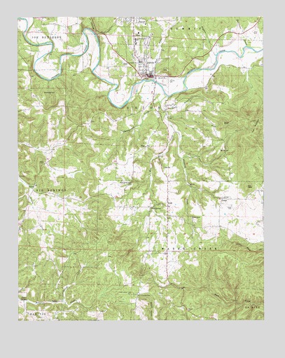
Yellville, AR USGS Topographic Map
Click on map above to begin viewing in our Map Viewer.

This topographic map contains these locations and features:
Feature Name Type Latitude Longitude GNIS ID View Map
Bald JesseSummitN36.1801°W92.6335°57310View Map
Big Springs (historical)Populated PlaceN36.1797°W92.7424°2572425View Map
Brown ChurchChurchN36.1965°W92.6854°76428View Map
Burns Funeral Home Parking Lot HeliportAirportN36.2326°W92.6882°83864View Map
Campground CreekStreamN36.2151°W92.6774°76514View Map
City of YellvilleCivilN36.2288°W92.6861°2405799View Map
CowanPopulated PlaceN36.1753°W92.6463°57594View Map
Cowan CemeteryCemeteryN36.1712°W92.6410°48121View Map
Dean BranchStreamN36.2117°W92.6757°48431View Map
East Prong Town BranchStreamN36.2262°W92.6816°48773View Map
Freck Lookout TowerTowerN36.1359°W92.6929°82434View Map
Georges CreekStreamN36.2498°W92.7488°49378View Map
Glenn SpringSpringN36.1337°W92.7463°49450View Map
Goard PointSummitN36.2065°W92.6454°57824View Map
Gray SpringSpringN36.1712°W92.6827°49614View Map
Hogskin CreekStreamN36.2342°W92.6491°50178View Map
Hurricane CreekStreamN36.2381°W92.6338°50451View Map
KCTT-AM (Yellville)TowerN36.2042°W92.6699°85153View Map
Marion County CourthouseBuildingN36.2256°W92.6818°61102View Map
Marion County Hospital (historical)HospitalN36.2317°W92.6879°61103View Map
Marion County Sheriff's OfficeBuildingN36.2258°W92.6796°2118846View Map
Mill CreekStreamN36.2176°W92.6727°51996View Map
Nanny CemeteryCemeteryN36.1901°W92.7365°77788View Map
Neilon CreekStreamN36.1331°W92.7277°52603View Map
New Hope Baptist ChurchChurchN36.1723°W92.6738°61101View Map
Pleasant Ridge CemeteryCemeteryN36.1659°W92.6610°61100View Map
Pleasant Ridge Methodist ChurchChurchN36.1665°W92.6618°78058View Map
RalphPopulated PlaceN36.1720°W92.6743°53884View Map
Ralph - Caney Rural Fire Protection UnitBuildingN36.1684°W92.6745°2117012View Map
Ralph Natural BridgeArchN36.1814°W92.6925°52581View Map
Rocky Hollow School (historical)SchoolN36.1417°W92.6882°81925View Map
Shakerag CreekStreamN36.2028°W92.6704°54728View Map
Standing RockPillarN36.2190°W92.7371°55150View Map
Summit Baptist ChurchChurchN36.2495°W92.6952°61105View Map
Summit Post OfficePost OfficeN36.2486°W92.6904°83965View Map
Town BranchStreamN36.2253°W92.6652°55616View Map
Township of Big Springs (historical)CivilN36.1917°W92.7488°69626View Map
Township of Union (historical)CivilN36.2126°W92.6641°69647View Map
Township of Water Creek (historical)CivilN36.1501°W92.6682°69648View Map
Wickersham CemeteryCemeteryN36.2134°W92.6757°56341View Map
Wood CemeteryCemeteryN36.2434°W92.6296°78802View Map
YellvillePopulated PlaceN36.2262°W92.6849°78820View Map
Yellville - Summit Elementary SchoolSchoolN36.2396°W92.6896°83539View Map
Yellville - Summit High SchoolSchoolN36.2407°W92.6898°61104View Map
Yellville - Summit Middle SchoolSchoolN36.2393°W92.6901°2039022View Map
Yellville CemeteryCemeteryN36.2242°W92.6715°78821View Map
Yellville Volunteer Fire DepartmentBuildingN36.2297°W92.6852°2117344View Map
Yellville-summit Elementary SchoolSchoolN36.2392°W92.6899°2039025View Map

Note: Coordinates in the location and feature list above are referenced to NAD83 datum.


Copyright (C) 2008-2024 Ryan Niemi / Sunset Dynamics ... All Rights Reserved