TopoQuest Logo
Do you find TopoQuest useful?
Help keep TopoQuest running and adding new maps/features by donating!
Bitcoin:  19c7KJd3qBynnjoSw5npx9KScwjBe4ifkT
Litecoin:  LXs6TkuXGGXo1vDsWCkWVdjQX94eUKd6ui
Home View Maps Find Maps Find Places Resources & Links


Randolph, New York Topographic Map

USGS Map Title: Randolph, NY
USGS Map MRC: 42078B8
DRG (GeoTIFF) Download: o42078b8.tif


Neighboring USGS Topographic Map Quads:


  Cherry Creek, NY  
42079C1
 

  New Albion, NY  
42078C8
 

  Cattaraugus, NY  
42078C7
 

  Kennedy, NY  
42079B1
 

  Randolph, NY  
42078B8
 

  Little Valley, NY  
42078B7
 

  Ivory, NY  
42079A1
 

  Steamburg, NY  
42078A8
 

  Red House, NY  
42078A7


Map MRC Location:

N43°
W79°
N43°
W78°
H8 H7 H6 H5 H4 H3 H2 H1
G8 G7 G6 G5 G4 G3 G2 G1
F8 F7 F6 F5 F4 F3 F2 F1
E8 E7 E6 E5 E4 E3 E2 E1
D8 D7 D6 D5 D4 D3 D2 D1
C8 C7 C6 C5 C4 C3 C2 C1
B8 B7 B6 B5 B4 B3 B2 B1
A8 A7 A6 A5 A4 A3 A2 A1
N42°
W79°
N42°
W78°

Randolph, NY USGS 1:24K Topographic Map Preview:
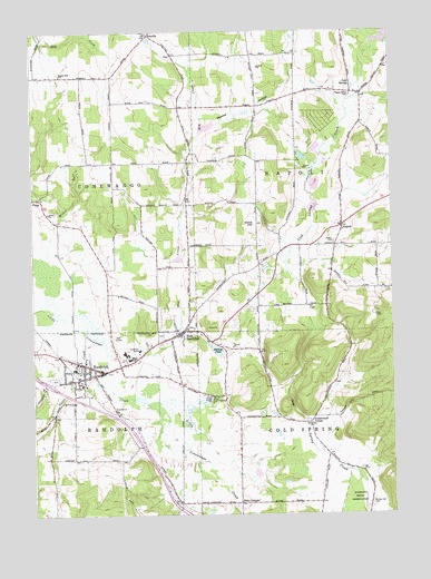
Randolph, NY USGS Topographic Map
Click on map above to begin viewing in our Map Viewer.

This topographic map contains these locations and features:
Feature Name Type Latitude Longitude GNIS ID View Map
AxevillePopulated PlaceN42.2492°W78.9592°972186View Map
Axeville CemeteryCemeteryN42.2439°W78.9508°2554918View Map
Battle CreekStreamN42.1731°W78.9823°943169View Map
Bunker Hill CemeteryCemeteryN42.1282°W78.8828°945182View Map
Cardinal Hills Golf CourseLocaleN42.1711°W78.9706°2400842View Map
Cold SpringSpringN42.2359°W78.8889°947056View Map
Cowen's Flying Field (historical)AirportN42.1669°W78.9528°2400725View Map
East RandolphPopulated PlaceN42.1728°W78.9478°949225View Map
East Randolph CemeteryCemeteryN42.1718°W78.9554°2400846View Map
East Randolph Census Designated PlaceCensusN42.1692°W78.9521°2746454View Map
East Randolph Fire CompanyBuildingN42.1715°W78.9495°2400840View Map
East Randolph Post OfficePost OfficeN42.1726°W78.9481°2598450View Map
East Randolph ReservoirReservoirN42.1736°W78.9389°2400841View Map
East Randolph United Methodist ChurchChurchN42.1728°W78.9497°2400844View Map
Edwards Memorial Methodist Episcopal Church (historical)ChurchN42.1614°W78.9797°2400830View Map
Elm CreekStreamN42.1553°W78.9662°949539View Map
Faith Bible ChapelChurchN42.1649°W78.9870°2597402View Map
Faith Lighthouse ChapelChurchN42.1750°W78.9447°2597403View Map
First Baptist ChurchChurchN42.1634°W78.9689°2597408View Map
First Congregational Church (historical)ChurchN42.1614°W78.9808°2400831View Map
First Presbyterian ChurchChurchN42.1622°W78.9808°2400833View Map
Free Methodist ChurchChurchN42.1714°W78.9497°2400839View Map
Gail N Chapman Elementary SchoolSchoolN42.1667°W78.9682°2667602View Map
Grace Episcopal ChurchChurchN42.1622°W78.9828°2400837View Map
Hoxie HillSummitN42.2001°W78.9228°953342View Map
Legion ParkParkN42.1622°W78.9758°2400726View Map
NapoliPopulated PlaceN42.1998°W78.8920°958260View Map
Napoli United Methodist ChurchChurchN42.2000°W78.8908°2400845View Map
Peaslee HollowValleyN42.2245°W78.9406°960065View Map
Pigeon Valley CemeteryCemeteryN42.2334°W78.8887°960382View Map
Price CornersLocaleN42.1281°W78.9284°961130View Map
RandolphPopulated PlaceN42.1620°W78.9753°962181View Map
Randolph AcademySchoolN42.1683°W78.9617°2597174View Map
Randolph CemeteryCemeteryN42.1602°W78.9926°2400724View Map
Randolph Census Designated PlaceCensusN42.1612°W78.9802°2746455View Map
Randolph Fire DepartmentBuildingN42.1634°W78.9743°2400728View Map
Randolph Fire Department Station 2BuildingN42.1599°W78.9847°2400836View Map
Randolph Free LibraryBuildingN42.1631°W78.9772°2400829View Map
Randolph Manor Assisted Living CenterBuildingN42.1642°W78.9693°2598241View Map
Randolph Middle SchoolSchoolN42.1668°W78.9678°2667603View Map
Randolph Post OfficePost OfficeN42.1627°W78.9750°2599616View Map
Randolph Senior High SchoolSchoolN42.1656°W78.9662°2400838View Map
Randolph United Presbyterian ChurchChurchN42.1614°W78.9808°2400832View Map
Randolph Village OfficesBuildingN42.1622°W78.9767°2400727View Map
Saint Patrick's Roman Catholic ChurchChurchN42.1608°W78.9808°2400835View Map
School Street Building Randolph Central School (historical)SchoolN42.1622°W78.9792°2400834View Map
Seager Hill SchoolSchoolN42.2389°W78.9898°964730View Map
Seventh Day Adventist ChurchChurchN42.1647°W78.9817°2400843View Map
South Napoli CemeteryCemeteryN42.1956°W78.8945°958261View Map
Stillson PondLakeN42.1675°W78.9359°966432View Map
Town of NapoliCivilN42.2165°W78.8845°979249View Map
Underwood CornerPopulated PlaceN42.1487°W78.9036°973175View Map
Village of East RandolphCivilN42.1692°W78.9521°2391653View Map
Village of RandolphCivilN42.1612°W78.9802°2391086View Map
Willis GulfValleyN42.2001°W78.9920°971325View Map

Note: Coordinates in the location and feature list above are referenced to NAD83 datum.


Copyright (C) 2008-2025 Ryan Niemi / Sunset Dynamics ... All Rights Reserved