TopoQuest Logo
Do you find TopoQuest useful?
Help keep TopoQuest running and adding new maps/features by donating!
Bitcoin:  19c7KJd3qBynnjoSw5npx9KScwjBe4ifkT
Litecoin:  LXs6TkuXGGXo1vDsWCkWVdjQX94eUKd6ui
Home View Maps Find Maps Find Places Resources & Links


Steamburg, New York Topographic Map

USGS Map Title: Steamburg, NY
USGS Map MRC: 42078A8
DRG (GeoTIFF) Download: o42078a8.tif


Neighboring USGS Topographic Map Quads:


  Kennedy, NY  
42079B1
 

  Randolph, NY  
42078B8
 

  Little Valley, NY  
42078B7
 

  Ivory, NY  
42079A1
 

  Steamburg, NY  
42078A8
 

  Red House, NY  
42078A7
 

  Scandia, PA  
41079H1
 

  Cornplanter Run, PA  
41078H8
 

  Stickney, PA  
41078H7


Map MRC Location:

N43°
W79°
N43°
W78°
H8 H7 H6 H5 H4 H3 H2 H1
G8 G7 G6 G5 G4 G3 G2 G1
F8 F7 F6 F5 F4 F3 F2 F1
E8 E7 E6 E5 E4 E3 E2 E1
D8 D7 D6 D5 D4 D3 D2 D1
C8 C7 C6 C5 C4 C3 C2 C1
B8 B7 B6 B5 B4 B3 B2 B1
A8 A7 A6 A5 A4 A3 A2 A1
N42°
W79°
N42°
W78°

Steamburg, NY USGS 1:24K Topographic Map Preview:
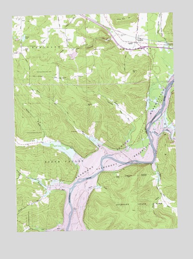
Steamburg, NY USGS Topographic Map
Click on map above to begin viewing in our Map Viewer.

This topographic map contains these locations and features:
Feature Name Type Latitude Longitude GNIS ID View Map
Bone RunStreamN42.0306°W78.9437°944421View Map
Braley HillSummitN42.0728°W78.9434°944609View Map
Browns HollowValleyN42.0196°W78.8864°944946View Map
Browns RunStreamN42.0256°W78.9725°944959View Map
Carr CornersLocaleN42.0884°W78.9645°945897View Map
Cold Spring School Number 3SchoolN42.1081°W78.9067°947080View Map
Coles Landing Airport (historical)AirportN42.0506°W78.9870°978311View Map
Halliday IslandIslandN42.0389°W78.9073°952064View Map
High PeakCliffN42.0570°W78.8975°952748View Map
Holts RunStreamN42.0553°W78.8784°953029View Map
Hotchkiss HollowValleyN42.0596°W78.9074°953270View Map
Hotchkiss RunStreamN42.0434°W78.9236°953271View Map
Johnny Watt HillSummitN42.1220°W78.9089°954091View Map
North Branch Sawmill RunStreamN42.0337°W78.9962°958721View Map
Old Town CemeteryCemeteryN42.0459°W78.9138°959337View Map
OnovillePopulated PlaceN42.0270°W78.9653°972896View Map
Peters CreekStreamN42.0289°W78.9459°960236View Map
Phillips BrookStreamN42.0523°W78.9792°960298View Map
Pickup LakeLakeN42.1122°W78.9913°960339View Map
Pierce RunStreamN42.0434°W78.9284°960358View Map
Pine CreekStreamN42.0820°W78.8773°960432View Map
Pine HillSummitN42.1051°W78.9906°960461View Map
Quaker BridgeLocaleN42.0709°W78.8823°962031View Map
Quaker RunStreamN42.0564°W78.8956°962056View Map
Round TopSummitN42.0914°W78.9081°963020View Map
Sawmill RunStreamN42.0245°W78.9581°964535View Map
South Branch Sawmill RunStreamN42.0337°W78.9962°965704View Map
State Line RunStreamN42.0009°W78.9776°966275View Map
SteamburgPopulated PlaceN42.1081°W78.9042°966312View Map
Steamburg CemeteryCemeteryN42.1123°W78.9163°966313View Map
Steamburg Fire DepartmentBuildingN42.1082°W78.9093°2700878View Map
Steamburg Post OfficePost OfficeN42.1084°W78.9040°2599254View Map
Town of South ValleyCivilN42.0419°W78.9961°979510View Map
Wolf RunStreamN42.0381°W78.8936°971582View Map

Note: Coordinates in the location and feature list above are referenced to NAD83 datum.


Copyright (C) 2008-2025 Ryan Niemi / Sunset Dynamics ... All Rights Reserved