TopoQuest Logo
Do you find TopoQuest useful?
Help keep TopoQuest running and adding new maps/features by donating!
Bitcoin:  19c7KJd3qBynnjoSw5npx9KScwjBe4ifkT
Litecoin:  LXs6TkuXGGXo1vDsWCkWVdjQX94eUKd6ui
Home View Maps Find Maps Find Places Resources & Links


Cattaraugus, New York Topographic Map

USGS Map Title: Cattaraugus, NY
USGS Map MRC: 42078C7
DRG (GeoTIFF) Download: o42078c7.tif


Neighboring USGS Topographic Map Quads:


  Gowanda, NY  
42078D8
 

  Collins Center, NY  
42078D7
 

  Ashford Hollow, NY  
42078D6
 

  New Albion, NY  
42078C8
 

  Cattaraugus, NY  
42078C7
 

  Ellicottville, NY  
42078C6
 

  Randolph, NY  
42078B8
 

  Little Valley, NY  
42078B7
 

  Salamanca, NY  
42078B6


Map MRC Location:

N43°
W79°
N43°
W78°
H8 H7 H6 H5 H4 H3 H2 H1
G8 G7 G6 G5 G4 G3 G2 G1
F8 F7 F6 F5 F4 F3 F2 F1
E8 E7 E6 E5 E4 E3 E2 E1
D8 D7 D6 D5 D4 D3 D2 D1
C8 C7 C6 C5 C4 C3 C2 C1
B8 B7 B6 B5 B4 B3 B2 B1
A8 A7 A6 A5 A4 A3 A2 A1
N42°
W79°
N42°
W78°

Cattaraugus, NY USGS 1:24K Topographic Map Preview:
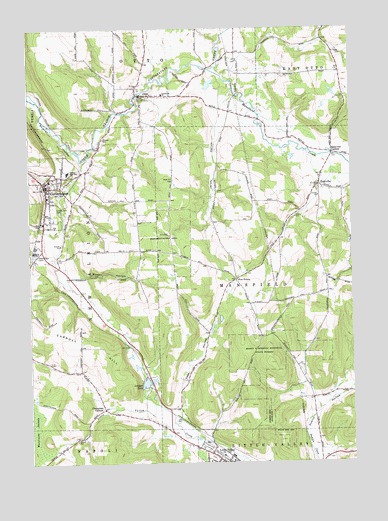
Cattaraugus, NY USGS Topographic Map
Click on map above to begin viewing in our Map Viewer.

This topographic map contains these locations and features:
Feature Name Type Latitude Longitude GNIS ID View Map
Berdick FieldAirportN42.3340°W78.7909°977951View Map
California Mill School (historical)SchoolN42.3028°W78.7583°2491158View Map
Carroll HillSummitN42.2773°W78.8428°969964View Map
CattaraugusPopulated PlaceN42.3292°W78.8681°946066View Map
Cattaraugus - Little Valley High SchoolSchoolN42.3348°W78.8591°946232View Map
Cattaraugus - Little Valley Middle SchoolSchoolN42.3338°W78.8598°2667582View Map
Cattaraugus Area Ambulance ServiceBuildingN42.3227°W78.8689°2719174View Map
Cattaraugus CampLocaleN42.3109°W78.8728°946067View Map
Cattaraugus Campus Elementary SchoolSchoolN42.3333°W78.8603°2667583View Map
Cattaraugus County Sheriff's OfficeBuildingN42.2522°W78.8011°2780352View Map
Cattaraugus Free LibraryBuildingN42.3297°W78.8689°2599617View Map
Cattaraugus Volunteer Fire CompanyBuildingN42.3200°W78.8686°2734821View Map
Champlain CornersLocaleN42.2656°W78.8470°946364View Map
Community Church of EddyvilleChurchN42.3331°W78.7621°2597398View Map
Dublin School (historical)SchoolN42.2703°W78.7600°2491147View Map
East Hill CemeteryCemeteryN42.3554°W78.8285°2554878View Map
EddyvillePopulated PlaceN42.3298°W78.7628°949361View Map
Eddyville CemeteryCemeteryN42.3324°W78.7616°2554901View Map
Eddyville CornersLocaleN42.3390°W78.7573°949362View Map
Faith Baptist ChurchChurchN42.3428°W78.7568°2597401View Map
Five PointsPopulated PlaceN42.3028°W78.7956°972476View Map
Five Points School (historical)SchoolN42.2953°W78.7894°2491157View Map
Gowan HollowValleyN42.3035°W78.8587°951429View Map
Harry E Dobbins Memorial State ForestForestN42.2803°W78.7848°952294View Map
Immanuel Lutheran CemeteryCemeteryN42.3585°W78.8383°2554881View Map
Immanuel Lutheran Church of OttoChurchN42.3561°W78.8227°953611View Map
Jersey HollowValleyN42.3472°W78.8008°954019View Map
Jersey School (historical)SchoolN42.3347°W78.8028°2491159View Map
Liberty Park CemeteryCemeteryN42.3240°W78.8652°955277View Map
Linlyco LakeLakeN42.2730°W78.8305°955422View Map
Little ValleyPopulated PlaceN42.2526°W78.8056°955720View Map
Little Valley Rural CemeteryCemeteryN42.2518°W78.8050°2554897View Map
Little Valley United Methodist ChurchChurchN42.2506°W78.7982°2597425View Map
Mansfield CreekStreamN42.3634°W78.8053°956382View Map
Milk School (historical)SchoolN42.3078°W78.8697°2491177View Map
OttoPopulated PlaceN42.3562°W78.8317°959581View Map
Otto Volunteer Fire DepartmentBuildingN42.3564°W78.8306°2734676View Map
Reed School (historical)SchoolN42.3679°W78.7562°2491146View Map
Roberts Memorial Free Methodist ChurchChurchN42.3229°W78.8674°2597435View Map
Rumsey CemeteryCemeteryN42.3192°W78.8705°2554895View Map
Saint John's United Church of ChristChurchN42.3308°W78.8633°2491184View Map
Saint Mary's ChurchChurchN42.3303°W78.8677°2597441View Map
Scott School (historical)SchoolN42.3678°W78.7945°2491145View Map
Sinn Valley GardensLocaleN42.2711°W78.8267°2544022View Map
Sprague School (historical)SchoolN42.3108°W78.8261°2491160View Map
Toad HollowValleyN42.2626°W78.8175°967575View Map
Toad Hollow School (historical)SchoolN42.2761°W78.8136°2491148View Map
Town of MansfieldCivilN42.3029°W78.7610°979193View Map
Ultralight PortAirportN42.2931°W78.7898°978117View Map
Village of CattaraugusCivilN42.3300°W78.8673°2391589View Map
Waite HollowValleyN42.3167°W78.8617°968648View Map
Wesleyan ChurchChurchN42.2541°W78.8108°2597450View Map
Wesleyan Church of CattaraugusChurchN42.3277°W78.8671°2491185View Map
West Hill CemeteryCemeteryN42.3316°W78.8189°969262View Map
Wilson CemeteryCemeteryN42.3283°W78.8021°2554899View Map

Note: Coordinates in the location and feature list above are referenced to NAD83 datum.


Copyright (C) 2008-2025 Ryan Niemi / Sunset Dynamics ... All Rights Reserved