TopoQuest Logo
Do you find TopoQuest useful?
Help keep TopoQuest running and adding new maps/features by donating!
Bitcoin:  19c7KJd3qBynnjoSw5npx9KScwjBe4ifkT
Litecoin:  LXs6TkuXGGXo1vDsWCkWVdjQX94eUKd6ui
Home View Maps Find Maps Find Places Resources & Links


Rathdrum, Idaho Topographic Map

USGS Map Title: Rathdrum, ID
USGS Map MRC: 47116G8
DRG (GeoTIFF) Download: o47116g8.tif


Neighboring USGS Topographic Map Quads:


  Mount Spokane, WA  
47117H1
 

  Spirit Lake West, ID  
47116H8
 

  Spirit Lake East, ID  
47116H7
 

  Newman Lake, WA  
47117G1
 

  Rathdrum, ID  
47116G8
 

  Hayden, ID  
47116G7
 

  Liberty Lake, WA  
47117F1
 

  Post Falls, ID  
47116F8
 

  Coeur D'Alene, ID  
47116F7


Map MRC Location:

N48°
W117°
N48°
W116°
H8 H7 H6 H5 H4 H3 H2 H1
G8 G7 G6 G5 G4 G3 G2 G1
F8 F7 F6 F5 F4 F3 F2 F1
E8 E7 E6 E5 E4 E3 E2 E1
D8 D7 D6 D5 D4 D3 D2 D1
C8 C7 C6 C5 C4 C3 C2 C1
B8 B7 B6 B5 B4 B3 B2 B1
A8 A7 A6 A5 A4 A3 A2 A1
N47°
W117°
N47°
W116°

Rathdrum, ID USGS 1:24K Topographic Map Preview:
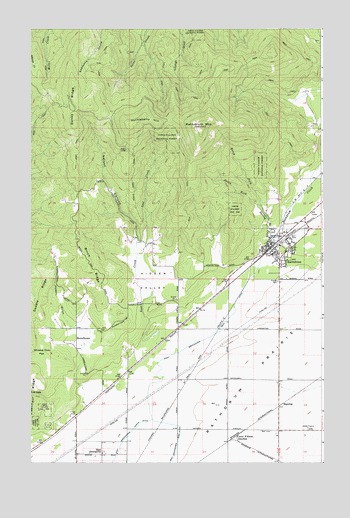
Rathdrum, ID USGS Topographic Map
Click on map above to begin viewing in our Map Viewer.

This topographic map contains these locations and features:
Feature Name Type Latitude Longitude GNIS ID View Map
Birch RidgeRidgeN47.8088°W116.9774°377673View Map
City of RathdrumCivilN47.7993°W116.8910°2411521View Map
Coeur d'Alene JunctionPopulated PlaceN47.7566°W116.9124°397562View Map
Danby RidgeRidgeN47.8488°W116.9816°380234View Map
East GreenacresPopulated PlaceN47.7524°W116.9699°397674View Map
East Greenacres Main DitchCanalN47.7866°W116.9230°381204View Map
East Greenacres North DitchCanalN47.7555°W116.9613°396433View Map
Eisenhour RidgeRidgeN47.7755°W116.9991°381290View Map
Four CornersLocaleN47.7893°W116.9813°400532View Map
HaycropPopulated PlaceN47.7663°W116.8938°382983View Map
Hidden ValleyBasinN47.8030°W116.9494°383162View Map
Howell GulchValleyN47.7905°W116.9841°383486View Map
HowelltownPopulated PlaceN47.7857°W116.9810°397801View Map
Huckleberry HillSummitN47.8496°W116.9521°397803View Map
John Brown Elementary SchoolSchoolN47.8147°W116.8889°401513View Map
Lakeland Junior High SchoolSchoolN47.8151°W116.8856°401535View Map
Lakeland Senior High SchoolSchoolN47.8156°W116.8794°394191View Map
Lakeland Senior High SchoolSchoolN47.8171°W116.8794°401536View Map
Lakeland Shopping CenterLocaleN47.8168°W116.8821°395605View Map
Lost CreekStreamN47.7868°W116.9469°386140View Map
Nelson CanyonValleyN47.8141°W116.9577°387505View Map
North Fork Spring Branch CreekStreamN47.8232°W116.9010°400016View Map
Northern Lakes Fire Protection District Station 2BuildingN47.8162°W116.8896°2619310View Map
Northern Lakes Fire Protection District Station 6BuildingN47.7851°W116.9667°2619179View Map
Post Falls-Rathdrum DivisionCivilN47.7638°W116.9562°1936791View Map
RathdrumPopulated PlaceN47.8124°W116.8966°398027View Map
Rathdrum CreekStreamN47.8146°W116.8958°389122View Map
Rathdrum Elementary SchoolSchoolN47.8127°W116.8935°394192View Map
Rathdrum MountainSummitN47.8468°W116.9274°389123View Map
Rathdrum Police DepartmentBuildingN47.8105°W116.8972°2547881View Map
Rathdrum Post OfficePost OfficeN47.8178°W116.8887°2767321View Map
Rathdrum Upper Elementary SchoolSchoolN47.8124°W116.8938°401130View Map
Scenic LodgeLocaleN47.8402°W116.9591°390008View Map
South Fork Spring Branch CreekStreamN47.8232°W116.9013°400101View Map
Spring Branch CreekStreamN47.8149°W116.8963°391152View Map
Whiskey Dick FlatFlatN47.7816°W116.9969°393294View Map

Note: Coordinates in the location and feature list above are referenced to NAD83 datum.


Copyright (C) 2008-2025 Ryan Niemi / Sunset Dynamics ... All Rights Reserved