TopoQuest Logo
Do you find TopoQuest useful?
Help keep TopoQuest running and adding new maps/features by donating!
Bitcoin:  19c7KJd3qBynnjoSw5npx9KScwjBe4ifkT
Litecoin:  LXs6TkuXGGXo1vDsWCkWVdjQX94eUKd6ui
Home View Maps Find Maps Find Places Resources & Links


Cotter, Arkansas Topographic Map

USGS Map Title: Cotter, AR
USGS Map MRC: 36092C5
DRG (GeoTIFF) Download: o36092c5.tif


Neighboring USGS Topographic Map Quads:


  Cotter NW, AR  
36092D6
 

  Bull Shoals, AR  
36092D5
 

  Midway, AR  
36092D4
 

  Cotter SW, AR  
36092C6
 

  Cotter, AR  
36092C5
 

  Mountain Home West, AR  
36092C4
 

  Yellville, AR  
36092B6
 

  Rea Valley, AR  
36092B5
 

  Buffalo City, AR  
36092B4


Map MRC Location:

N37°
W93°
N37°
W92°
H8 H7 H6 H5 H4 H3 H2 H1
G8 G7 G6 G5 G4 G3 G2 G1
F8 F7 F6 F5 F4 F3 F2 F1
E8 E7 E6 E5 E4 E3 E2 E1
D8 D7 D6 D5 D4 D3 D2 D1
C8 C7 C6 C5 C4 C3 C2 C1
B8 B7 B6 B5 B4 B3 B2 B1
A8 A7 A6 A5 A4 A3 A2 A1
N36°
W93°
N36°
W92°

Cotter, AR USGS 1:24K Topographic Map Preview:
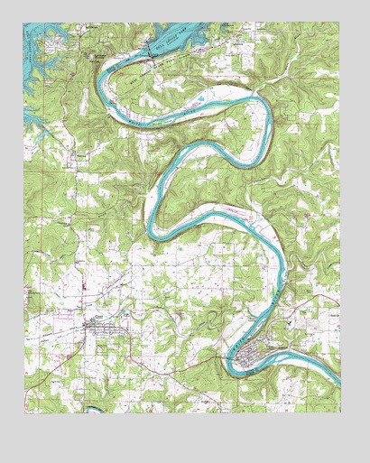
Cotter, AR USGS Topographic Map
Click on map above to begin viewing in our Map Viewer.

This topographic map contains these locations and features:
Feature Name Type Latitude Longitude GNIS ID View Map
Amanda Gist Elementary SchoolSchoolN36.2785°W92.5204°83442View Map
AmosPopulated PlaceN36.3659°W92.5549°69335View Map
Amos CemeteryCemeteryN36.3645°W92.5457°45857View Map
Amos School (historical)SchoolN36.3653°W92.5454°69336View Map
Antioch Number 1 Baptist ChurchChurchN36.2873°W92.5702°76180View Map
Bayless IslandIslandN36.2770°W92.5329°46171View Map
Bruce CreekStreamN36.3517°W92.5346°47031View Map
Bull Shoals Community Hospital and ClinicHospitalN36.3745°W92.5841°61082View Map
Bull Shoals DamDamN36.3662°W92.5748°83588View Map
Bull Shoals MountainSummitN36.3637°W92.5985°57467View Map
Bull Shoals Natural ParkParkN36.3712°W92.5766°61083View Map
Bull Shoals State ParkParkN36.3606°W92.5746°47175View Map
Burch CemeteryCemeteryN36.2715°W92.5963°47187View Map
Cane IslandIslandN36.3428°W92.5702°47384View Map
City of Bull ShoalsCivilN36.3749°W92.5901°2403951View Map
City of CotterCivilN36.2818°W92.5210°2404136View Map
City of FlippinCivilN36.2774°W92.5927°2403618View Map
City of LakeviewCivilN36.3740°W92.5388°2404876View Map
Collis Ferry (historical)CrossingN36.3503°W92.5377°69353View Map
CotterPopulated PlaceN36.2712°W92.5354°76681View Map
Cotter - Gassville Rural Volunteer Fire District Station 2BuildingN36.3083°W92.5683°2116310View Map
Cotter BridgeBridgeN36.2673°W92.5441°69357View Map
Cotter CemeteryCemeteryN36.2820°W92.5127°76682View Map
Cotter High SchoolSchoolN36.2789°W92.5212°69358View Map
Cotter Police DepartmentBuildingN36.2666°W92.5394°2118849View Map
Cotter Volunteer Fire DepartmentBuildingN36.2665°W92.5397°2116311View Map
Crane CreekStreamN36.2803°W92.5896°48138View Map
Denton Ferry (historical)CrossingN36.2978°W92.5238°69362View Map
Dew SpringSpringN36.3503°W92.5916°48497View Map
Dews FordCrossingN36.3487°W92.5904°61081View Map
East Cotter ChurchChurchN36.2748°W92.5107°48756View Map
FairviewPopulated PlaceN36.3334°W92.6046°48966View Map
Fairview CemeteryCemeteryN36.3287°W92.6049°48970View Map
Fairview Church of ChristChurchN36.3340°W92.6057°61080View Map
Fairview Rural Volunteer Fire DepartmentBuildingN36.3339°W92.6053°2116422View Map
Fairview School (historical)SchoolN36.3337°W92.6049°81922View Map
Fallen Ash CreekStreamN36.2806°W92.5327°48997View Map
FlippinPopulated PlaceN36.2790°W92.5971°76941View Map
Flippin CemeteryCemeteryN36.2848°W92.5946°61079View Map
Flippin Elementary SchoolSchoolN36.2800°W92.5978°61077View Map
Flippin Fire DepartmentBuildingN36.2781°W92.5980°2116431View Map
Flippin High SchoolSchoolN36.2802°W92.6006°61078View Map
Flippin Middle SchoolSchoolN36.2804°W92.5984°2039021View Map
Flippin Police DepartmentBuildingN36.2780°W92.5973°2118851View Map
Flippin Post OfficePost OfficeN36.2796°W92.5870°83970View Map
Gastons AirportAirportN36.3473°W92.5602°83742View Map
Hightower CreekStreamN36.3092°W92.5360°50105View Map
Hurst CemeteryCemeteryN36.2601°W92.6107°50462View Map
Jenkins BranchStreamN36.3220°W92.5721°50614View Map
Jenkins CemeteryCemeteryN36.3087°W92.5971°50618View Map
LakeviewPopulated PlaceN36.3687°W92.5454°77438View Map
Lakeview Police DepartmentBuildingN36.3682°W92.5450°2118859View Map
Lakeview Post OfficePost OfficeN36.3693°W92.5434°2781876View Map
Lithia CreekStreamN36.2931°W92.5232°51181View Map
Marion County Regional AirportAirportN36.2920°W92.5867°83701View Map
McBee LandingLocaleN36.2798°W92.5335°77624View Map
McBees Ferry (historical)CrossingN36.2801°W92.5321°61086View Map
Mooneys LandingLocaleN36.3126°W92.5416°69419View Map
Mouth of Bruce Creek LandingLocaleN36.3515°W92.5341°69409View Map
Pleasant Flat ChurchChurchN36.3723°W92.5388°53523View Map
The Valley AirportAirportN36.3129°W92.5391°83669View Map
Township of White River (historical)CivilN36.2876°W92.5752°69649View Map
Trammels ShuteChannelN36.3509°W92.5349°69452View Map
Trimble FlatFlatN36.3670°W92.5541°55650View Map
Whites Ferry (historical)CrossingN36.3309°W92.5429°69458View Map

Note: Coordinates in the location and feature list above are referenced to NAD83 datum.


Copyright (C) 2008-2025 Ryan Niemi / Sunset Dynamics ... All Rights Reserved