TopoQuest Logo
Do you find TopoQuest useful?
Help keep TopoQuest running and adding new maps/features by donating!
Bitcoin:  19c7KJd3qBynnjoSw5npx9KScwjBe4ifkT
Litecoin:  LXs6TkuXGGXo1vDsWCkWVdjQX94eUKd6ui
Home View Maps Find Maps Find Places Resources & Links


Red Springs, North Carolina Topographic Map

USGS Map Title: Red Springs, NC
USGS Map MRC: 34079G2
DRG (GeoTIFF) Download: o34079g2.tif


Neighboring USGS Topographic Map Quads:


  Wagram, NC  
34079H3
 

  Raeford, NC  
34079H2
 

  Parkton, NC  
34079H1
 

  Wakulla, NC  
34079G3
 

  Red Springs, NC  
34079G2
 

  Rennert, NC  
34079G1
 

  Maxton, NC  
34079F3
 

  Pembroke, NC  
34079F2
 

  Northwest Lumberton, NC  
34079F1


Map MRC Location:

N35°
W80°
N35°
W79°
H8 H7 H6 H5 H4 H3 H2 H1
G8 G7 G6 G5 G4 G3 G2 G1
F8 F7 F6 F5 F4 F3 F2 F1
E8 E7 E6 E5 E4 E3 E2 E1
D8 D7 D6 D5 D4 D3 D2 D1
C8 C7 C6 C5 C4 C3 C2 C1
B8 B7 B6 B5 B4 B3 B2 B1
A8 A7 A6 A5 A4 A3 A2 A1
N34°
W80°
N34°
W79°

Red Springs, NC USGS 1:24K Topographic Map Preview:
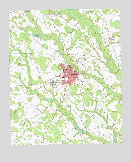
Red Springs, NC USGS Topographic Map
Click on map above to begin viewing in our Map Viewer.

This topographic map contains these locations and features:
Feature Name Type Latitude Longitude GNIS ID View Map
Alloway CemeteryCemeteryN34.8277°W79.1875°980147View Map
Antioch ChapelChurchN34.8657°W79.2009°980208View Map
Big Buie Pond DamDamN34.7602°W79.1664°998127View Map
Buie FieldAirportN34.7892°W79.1941°997861View Map
Buie Pond BigReservoirN34.7602°W79.1664°998126View Map
Buie Pond Dam SmallDamN34.7518°W79.1314°998123View Map
Buie Pond SmallReservoirN34.7549°W79.1331°998122View Map
Community Rest CemeteryCemeteryN34.8565°W79.1786°983418View Map
Galilee ChurchChurchN34.7993°W79.1500°985523View Map
Greenbrier LakeReservoirN34.8519°W79.2195°986092View Map
Hoke County ChurchChurchN34.8535°W79.1798°986913View Map
Island Grove ChurchChurchN34.7532°W79.2145°987430View Map
Johnsons ChapelChurchN34.8382°W79.1886°987696View Map
Jones ChapelChurchN34.8099°W79.1886°987732View Map
Juniper BranchStreamN34.8235°W79.1364°987836View Map
Long SwampStreamN34.8018°W79.2286°989013View Map
Lumbee State Designated Tribal Statistical AreaCensusN34.7887°W79.1543°2418691View Map
Macks ChapelChurchN34.7666°W79.1528°989214View Map
McLeans BranchStreamN34.8068°W79.1470°989612View Map
McNeil Pond DamDamN34.8518°W79.2164°998157View Map
Mount Elam ChurchChurchN34.8741°W79.2273°990373View Map
Peterson SchoolSchoolN34.8121°W79.1900°992101View Map
PhiladelphusPopulated PlaceN34.7591°W79.1714°992134View Map
Philadelphus ChurchChurchN34.8002°W79.1873°992135View Map
Pilgrim Grove ChurchChurchN34.8107°W79.1806°992199View Map
Prospect ChurchChurchN34.8491°W79.1273°992843View Map
Red SpringsPopulated PlaceN34.8152°W79.1831°1022199View Map
Red Springs Fire DepartmentBuildingN34.8174°W79.1823°2638839View Map
Red Springs High SchoolSchoolN34.8235°W79.1856°1006798View Map
Red Springs Industrial ParkLocaleN34.8335°W79.1788°2505182View Map
Red Springs Middle SchoolSchoolN34.8193°W79.1856°1006797View Map
Red Springs Police DepartmentBuildingN34.8145°W79.1831°2769708View Map
Red Springs Post OfficePost OfficeN34.8141°W79.1834°2774129View Map
Red Springs Rescue SquadBuildingN34.8065°W79.1672°2720626View Map
Red Springs Wastewater Treatment PlantLocaleN34.8120°W79.1624°2506015View Map
Rhyne Memorial ChurchChurchN34.8127°W79.1939°993275View Map
Saint James ChurchChurchN34.7632°W79.2484°993902View Map
Saint James ChurchChurchN34.8224°W79.1828°993903View Map
Saint Stephens ChurchChurchN34.8179°W79.1803°994131View Map
ShannonPopulated PlaceN34.8479°W79.1370°994576View Map
Shannon Census Designated PlaceCensusN34.8477°W79.1396°2402845View Map
Shannon ChurchChurchN34.8563°W79.1398°994577View Map
Shannon Post OfficePost OfficeN34.8478°W79.1379°2773906View Map
Shannon Volunteer Fire DepartmentBuildingN34.8477°W79.1381°2639066View Map
Town of Red SpringsCivilN34.8046°W79.1823°2407187View Map
Township of Red SpringsCivilN34.8125°W79.1751°1027117View Map
Township of ShannonCivilN34.8500°W79.1281°1027122View Map
Trinity ChurchChurchN34.8157°W79.1809°996233View Map
Vardell HallSchoolN34.8174°W79.1773°996593View Map
Westside ChurchChurchN34.8096°W79.1975°997079View Map
WSTS-FM (Laurinburg)TowerN34.8710°W79.1414°1018626View Map
WYRU-AM (Red Springs)TowerN34.8388°W79.1764°1018376View Map

Note: Coordinates in the location and feature list above are referenced to NAD83 datum.


Copyright (C) 2008-2024 Ryan Niemi / Sunset Dynamics ... All Rights Reserved