TopoQuest Logo
Do you find TopoQuest useful?
Help keep TopoQuest running and adding new maps/features by donating!
Bitcoin:  19c7KJd3qBynnjoSw5npx9KScwjBe4ifkT
Litecoin:  LXs6TkuXGGXo1vDsWCkWVdjQX94eUKd6ui
Home View Maps Find Maps Find Places Resources & Links


Maxton, North Carolina Topographic Map

USGS Map Title: Maxton, NC
USGS Map MRC: 34079F3
DRG (GeoTIFF) Download: o34079f3.tif


Neighboring USGS Topographic Map Quads:


  Laurinburg, NC  
34079G4
 

  Wakulla, NC  
34079G3
 

  Red Springs, NC  
34079G2
 

  Johns, NC  
34079F4
 

  Maxton, NC  
34079F3
 

  Pembroke, NC  
34079F2
 

  Minturn, SC  
34079E4
 

  Rowland, NC  
34079E3
 

  McDonald, NC  
34079E2


Map MRC Location:

N35°
W80°
N35°
W79°
H8 H7 H6 H5 H4 H3 H2 H1
G8 G7 G6 G5 G4 G3 G2 G1
F8 F7 F6 F5 F4 F3 F2 F1
E8 E7 E6 E5 E4 E3 E2 E1
D8 D7 D6 D5 D4 D3 D2 D1
C8 C7 C6 C5 C4 C3 C2 C1
B8 B7 B6 B5 B4 B3 B2 B1
A8 A7 A6 A5 A4 A3 A2 A1
N34°
W80°
N34°
W79°

Maxton, NC USGS 1:24K Topographic Map Preview:
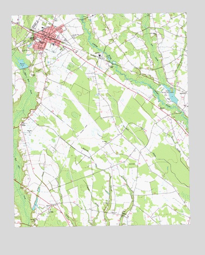
Maxton, NC USGS Topographic Map
Click on map above to begin viewing in our Map Viewer.

This topographic map contains these locations and features:
Feature Name Type Latitude Longitude GNIS ID View Map
AlmaPopulated PlaceN34.7238°W79.3125°1018805View Map
Amos ChapelChurchN34.6346°W79.3492°980172View Map
Antioch MissionChurchN34.6610°W79.2878°980254View Map
Beulah ChurchChurchN34.6329°W79.3037°981260View Map
Carolina Military Academy (historical)SchoolN34.7354°W79.3584°982666View Map
Country Club LakeReservoirN34.7017°W79.2613°998110View Map
Country Club Lake DamDamN34.6968°W79.2581°998111View Map
Dean SchoolSchoolN34.7318°W79.3448°984036View Map
Dothan ChurchChurchN34.7338°W79.3442°984276View Map
Evans Crossroads Volunteer Fire DepartmentBuildingN34.6738°W79.2921°2638444View Map
Gilbert Patterson Memorial Public LibraryBuildingN34.7390°W79.3494°2505950View Map
Gospel TabernacleChurchN34.6329°W79.2978°985864View Map
Gum SwampStreamN34.7068°W79.2670°986238View Map
Jowers BranchStreamN34.7104°W79.3606°987789View Map
Little Juniper BranchStreamN34.7043°W79.2595°988685View Map
Little Zion ChurchChurchN34.6291°W79.3598°988806View Map
Lumbee Recreation CenterParkN34.7021°W79.2642°989125View Map
MaxtonPopulated PlaceN34.7352°W79.3489°1021370View Map
Maxton Medical CenterHospitalN34.7329°W79.3448°2505725View Map
Maxton Police DepartmentBuildingN34.7374°W79.3511°2769642View Map
Maxton PondReservoirN34.7211°W79.3675°989489View Map
Maxton Pond DamDamN34.7185°W79.3667°998113View Map
Maxton Post OfficePost OfficeN34.7385°W79.3475°2773878View Map
Maxton Rescue SquadBuildingN34.7368°W79.3481°2720361View Map
McLeod Memorial CemeteryCemeteryN34.7282°W79.3681°989617View Map
McRae BranchStreamN34.6349°W79.3648°989652View Map
Midway ChurchChurchN34.6391°W79.3450°989821View Map
Mount Hebron ChurchChurchN34.6743°W79.3081°990394View Map
Mount Moriah ChurchChurchN34.6385°W79.3075°990431View Map
Oak Grove CemeteryCemeteryN34.7368°W79.3309°991351View Map
Preston Gospel ChapelChurchN34.7374°W79.2725°992792View Map
Queheel Fire DepartmentBuildingN34.7427°W79.3447°2639028View Map
RaemonPopulated PlaceN34.6377°W79.3487°992979View Map
Red BanksPopulated PlaceN34.7029°W79.2509°1022186View Map
Saint Matthews ChurchChurchN34.7296°W79.3520°994052View Map
Saint Pauls ChurchChurchN34.7360°W79.3506°994078View Map
Seven BridgesLocaleN34.6852°W79.3692°994508View Map
Town of MaxtonCivilN34.7365°W79.3527°2406111View Map
Townsend Middle SchoolSchoolN34.7341°W79.3531°1006796View Map
Township of AlfordsvilleCivilN34.6281°W79.3498°1027101View Map
Township of MaxtonCivilN34.6946°W79.3612°1027111View Map
Union Light ChurchChurchN34.6810°W79.3631°996506View Map
West Robeson Senior High SchoolSchoolN34.6954°W79.2525°1006794View Map
White Hill ChurchChurchN34.6935°W79.2700°997139View Map
Williams ChapelChurchN34.7188°W79.3050°997373View Map

Note: Coordinates in the location and feature list above are referenced to NAD83 datum.


Copyright (C) 2008-2024 Ryan Niemi / Sunset Dynamics ... All Rights Reserved