TopoQuest Logo
Do you find TopoQuest useful?
Help keep TopoQuest running and adding new maps/features by donating!
Bitcoin:  19c7KJd3qBynnjoSw5npx9KScwjBe4ifkT
Litecoin:  LXs6TkuXGGXo1vDsWCkWVdjQX94eUKd6ui
Home View Maps Find Maps Find Places Resources & Links


Clinton Falls, Indiana Topographic Map

USGS Map Title: Clinton Falls, IN
USGS Map MRC: 39086F8
DRG (GeoTIFF) Download: o39086f8.tif


Neighboring USGS Topographic Map Quads:


  Bellmore, IN  
39087G1
 

  Russellville, IN  
39086G8
 

  Roachdale, IN  
39086G7
 

  Mansfield, IN  
39087F1
 

  Clinton Falls, IN  
39086F8
 

  Greencastle, IN  
39086F7
 

  Brazil East, IN  
39087E1
 

  Reelsville, IN  
39086E8
 

  Cloverdale, IN  
39086E7


Map MRC Location:

N40°
W87°
N40°
W86°
H8 H7 H6 H5 H4 H3 H2 H1
G8 G7 G6 G5 G4 G3 G2 G1
F8 F7 F6 F5 F4 F3 F2 F1
E8 E7 E6 E5 E4 E3 E2 E1
D8 D7 D6 D5 D4 D3 D2 D1
C8 C7 C6 C5 C4 C3 C2 C1
B8 B7 B6 B5 B4 B3 B2 B1
A8 A7 A6 A5 A4 A3 A2 A1
N39°
W87°
N39°
W86°

Clinton Falls, IN USGS 1:24K Topographic Map Preview:
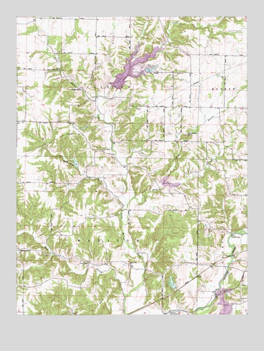
Clinton Falls, IN USGS Topographic Map
Click on map above to begin viewing in our Map Viewer.

This topographic map contains these locations and features:
Feature Name Type Latitude Longitude GNIS ID View Map
Bald HillSummitN39.6298°W86.9553°430445View Map
BrunerstownPopulated PlaceN39.6525°W86.9983°431667View Map
Clinton FallsPopulated PlaceN39.7192°W86.9639°432677View Map
Collins Covered BridgeBridgeN39.7273°W86.9758°432793View Map
Dunbar Covered BridgeBridgeN39.6587°W86.8836°433766View Map
Falls BranchStreamN39.6800°W86.9206°434383View Map
Glenn Flint LakeReservoirN39.7332°W86.9276°446680View Map
Jones CreekStreamN39.6742°W86.9367°437092View Map
Leatherman CreekStreamN39.6687°W86.9431°437706View Map
Little Walnut CemeteryCemeteryN39.6941°W86.9543°438168View Map
Little Walnut Creek Structure Number 3DamN39.6875°W86.9667°448537View Map
Long BranchStreamN39.6328°W86.9414°438250View Map
Long Branch ChurchChurchN39.6473°W86.9636°438254View Map
Madison Township Volunteer Fire DepartmentBuildingN39.6432°W86.9256°2625979View Map
Oakalla Covered BridgeBridgeN39.6264°W86.9170°440458View Map
Oakalla LakeReservoirN39.6384°W86.9159°447220View Map
Okalla Lake DamDamN39.6362°W86.9145°447221View Map
Owl CreekStreamN39.7150°W86.9567°440807View Map
Pleasant Hill ChurchChurchN39.6464°W86.9395°441279View Map
Township of ClintonCivilN39.7349°W86.9560°453233View Map
Township of MadisonCivilN39.6476°W86.9573°453597View Map
Van Bibber LakeReservoirN39.7277°W86.9280°447235View Map
Van Bibber LakePopulated PlaceN39.7287°W86.9284°2629899View Map
Van Bibber Lake Census Designated PlaceCensusN39.7292°W86.9297°2629870View Map
Van Bibber Lake DamDamN39.7267°W86.9300°447236View Map
Van Bibber Lake Volunteer Fire DepartmentBuildingN39.7262°W86.9238°2625751View Map
Vermillion FallsFallsN39.7009°W86.9071°452240View Map
WJNZ-FM (Greencastle)TowerN39.6606°W86.8928°448959View Map

Note: Coordinates in the location and feature list above are referenced to NAD83 datum.


Copyright (C) 2008-2025 Ryan Niemi / Sunset Dynamics ... All Rights Reserved