TopoQuest Logo
Do you find TopoQuest useful?
Help keep TopoQuest running and adding new maps/features by donating!
Bitcoin:  19c7KJd3qBynnjoSw5npx9KScwjBe4ifkT
Litecoin:  LXs6TkuXGGXo1vDsWCkWVdjQX94eUKd6ui
Home View Maps Find Maps Find Places Resources & Links


Reidsville East, Georgia Topographic Map

USGS Map Title: Reidsville East, GA
USGS Map MRC: 32082A1
DRG (GeoTIFF) Download: o32082a1.tif


Neighboring USGS Topographic Map Quads:


  Ohoopee, GA  
32082B2
 

  Collins, GA  
32082B1
 

  Claxton, GA  
32081B8
 

  Reidsville West, GA  
32082A2
 

  Reidsville East, GA  
32082A1
 

  Deans Crossing, GA  
32081A8
 

  Altamaha, GA  
31082H2
 

  Tison, GA  
31082H1
 

  Glennville, GA  
31081H8


Map MRC Location:

N33°
W83°
N33°
W82°
H8 H7 H6 H5 H4 H3 H2 H1
G8 G7 G6 G5 G4 G3 G2 G1
F8 F7 F6 F5 F4 F3 F2 F1
E8 E7 E6 E5 E4 E3 E2 E1
D8 D7 D6 D5 D4 D3 D2 D1
C8 C7 C6 C5 C4 C3 C2 C1
B8 B7 B6 B5 B4 B3 B2 B1
A8 A7 A6 A5 A4 A3 A2 A1
N32°
W83°
N32°
W82°

Reidsville East, GA USGS 1:24K Topographic Map Preview:
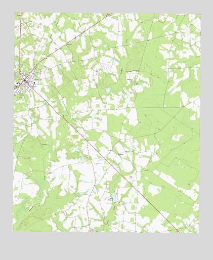
Reidsville East, GA USGS Topographic Map
Click on map above to begin viewing in our Map Viewer.

This topographic map contains these locations and features:
Feature Name Type Latitude Longitude GNIS ID View Map
Bradleys (historical)Populated PlaceN32.0244°W82.0129°347389View Map
City of ReidsvilleCivilN32.0871°W82.1244°2404604View Map
D L LakeReservoirN32.0420°W82.0781°341370View Map
D L Lake DamDamN32.0435°W82.0782°341369View Map
Douglas BranchStreamN32.0949°W82.0523°347400View Map
Durrence LakeReservoirN32.0223°W82.0783°341366View Map
Durrence Lake DamDamN32.0219°W82.0798°341365View Map
Gainwell CemeteryCemeteryN32.0805°W82.0465°314479View Map
Hammock CemeteryCemeteryN32.0419°W82.1182°315065View Map
Hodges PondReservoirN32.0913°W82.0065°341372View Map
Hodges Pond DamDamN32.0952°W82.0065°341371View Map
HughlandPopulated PlaceN32.0452°W82.0548°332041View Map
Jones MillpondReservoirN32.0201°W82.0570°341364View Map
Jones MillpondLocaleN32.0202°W82.0568°316247View Map
Jones Millpond DamDamN32.0169°W82.0565°341363View Map
Maddox CemeteryCemeteryN32.0924°W82.0679°317589View Map
Old Shiloh CemeteryCemeteryN32.0394°W82.0698°320024View Map
Optim Medical Center TattnallHospitalN32.0803°W82.1091°2611020View Map
Pine Grove ChurchChurchN32.1069°W82.0896°320566View Map
Pine View CemeteryCemeteryN32.0002°W82.0721°320652View Map
ReidsvillePopulated PlaceN32.0869°W82.1179°321516View Map
Reidsville DivisionCivilN32.0526°W82.1169°1936489View Map
Reidsville Elementary SchoolSchoolN32.0844°W82.1212°347433View Map
Reidsville Fire DepartmentBuildingN32.0837°W82.1203°2603871View Map
Reidsville High SchoolSchoolN32.0852°W82.1112°347434View Map
Reidsville Police DepartmentBuildingN32.0836°W82.1204°2733705View Map
Reidsville United Methodist ChurchChurchN32.0884°W82.1169°2502356View Map
Saint Williams ChurchChurchN32.0921°W82.0490°322322View Map
Segull LakeReservoirN32.0291°W82.0754°341368View Map
Segull Lake DamDamN32.0285°W82.0782°341367View Map
Shady Grove CemeteryCemeteryN32.0863°W82.0454°322738View Map
Shiloh ChurchChurchN32.0433°W82.0765°322868View Map
Shiloh School (historical)SchoolN32.0341°W82.0710°347439View Map
Smith CemeteryCemeteryN32.0844°W82.0426°323101View Map
Tattnall CountyCivilN32.0457°W82.0582°347445View Map
Tattnall County JailBuildingN32.0845°W82.1213°2734124View Map
Tattnall County Sheriff's OfficeBuildingN32.0846°W82.1215°2733741View Map
Tattnall Healthcare CenterHospitalN32.0825°W82.1079°2502559View Map
Tootle AirportAirportN32.0318°W82.0442°351882View Map
Wilds CemeteryCemeteryN32.0502°W82.1054°325290View Map
Zion Union ChurchChurchN32.0927°W82.0410°325716View Map

Note: Coordinates in the location and feature list above are referenced to NAD83 datum.


Copyright (C) 2008-2025 Ryan Niemi / Sunset Dynamics ... All Rights Reserved