TopoQuest Logo
Do you find TopoQuest useful?
Help keep TopoQuest running and adding new maps/features by donating!
Bitcoin:  19c7KJd3qBynnjoSw5npx9KScwjBe4ifkT
Litecoin:  LXs6TkuXGGXo1vDsWCkWVdjQX94eUKd6ui
Home View Maps Find Maps Find Places Resources & Links


Roberta, Georgia Topographic Map

USGS Map Title: Roberta, GA
USGS Map MRC: 32084F1
DRG (GeoTIFF) Download: o32084f1.tif


Neighboring USGS Topographic Map Quads:


  Logtown, GA  
32084G2
 

  Culloden, GA  
32084G1
 

  Moran, GA  
32083G8
 

  Fickling Mill, GA  
32084F2
 

  Roberta, GA  
32084F1
 

  Knoxville, GA  
32083F8
 

  Butler East, GA  
32084E2
 

  Reynolds, GA  
32084E1
 

  Fort Valley West, GA  
32083E8


Map MRC Location:

N33°
W85°
N33°
W84°
H8 H7 H6 H5 H4 H3 H2 H1
G8 G7 G6 G5 G4 G3 G2 G1
F8 F7 F6 F5 F4 F3 F2 F1
E8 E7 E6 E5 E4 E3 E2 E1
D8 D7 D6 D5 D4 D3 D2 D1
C8 C7 C6 C5 C4 C3 C2 C1
B8 B7 B6 B5 B4 B3 B2 B1
A8 A7 A6 A5 A4 A3 A2 A1
N32°
W85°
N32°
W84°

Roberta, GA USGS 1:24K Topographic Map Preview:
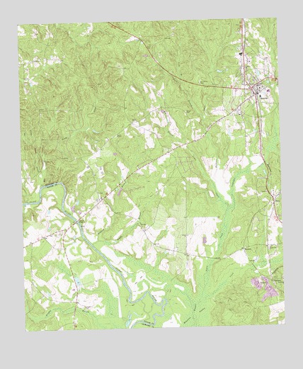
Roberta, GA USGS Topographic Map
Click on map above to begin viewing in our Map Viewer.

This topographic map contains these locations and features:
Feature Name Type Latitude Longitude GNIS ID View Map
Avery CreekStreamN32.6374°W84.0394°310684View Map
Bell DamDamN32.6451°W84.0982°340344View Map
Bell LakeReservoirN32.6450°W84.0991°340345View Map
Benjamin Hawkins MonumentParkN32.7199°W84.0105°342908View Map
Bethel CemeteryCemeteryN32.6624°W84.0455°342911View Map
Bethel ChurchChurchN32.6624°W84.0460°354598View Map
Big Beech CreekStreamN32.6838°W84.1157°311298View Map
Big Branch Lewis CreekStreamN32.6729°W84.0252°311350View Map
Boggy BranchStreamN32.6593°W84.0913°311606View Map
Central Georgia Technical College - Crawford County CenterSchoolN32.7145°W84.0212°2680235View Map
Chambliss CemeteryCemeteryN32.6640°W84.1094°344136View Map
City of RobertaCivilN32.7196°W84.0104°2404631View Map
Colonel Benjamin Hawkins GraveCemeteryN32.6668°W84.0960°342915View Map
Confederate CemeteryCemeteryN32.7482°W84.0762°342916View Map
Crawford County Comprehensive High SchoolSchoolN32.7204°W84.0049°342919View Map
Crawford County Elementary SchoolSchoolN32.7357°W84.0174°342921View Map
Crawford County Fire Department Station 1BuildingN32.7197°W84.0091°2604809View Map
Crawford County Fire Department Station 5BuildingN32.6773°W84.0879°2604350View Map
Crawford County Middle SchoolSchoolN32.7229°W84.0099°342923View Map
Culpepper CreekStreamN32.6729°W84.0252°355404View Map
Flowers Family CemeteryCemeteryN32.6629°W84.0462°2723039View Map
Ford BranchStreamN32.7249°W84.0474°314254View Map
FrancisvillePopulated PlaceN32.6743°W84.0910°342926View Map
GaillardPopulated PlaceN32.6435°W84.0052°326297View Map
Gaillard CemeteryCemeteryN32.6396°W84.0021°342928View Map
Gaillard ChurchChurchN32.6396°W84.0024°342929View Map
Gentle Landings Air ParkAirportN32.7137°W84.0281°2625381View Map
Grace BranchStreamN32.7099°W84.0363°314745View Map
GriffithPopulated PlaceN32.6365°W84.0999°344140View Map
HammettPopulated PlaceN32.6565°W84.0188°326316View Map
Hawkins BridgeBridgeN32.6690°W84.0988°356227View Map
Horne Family CemeteryCemeteryN32.7012°W84.0163°2722985View Map
HornsPopulated PlaceN32.6754°W84.0035°332027View Map
Jordan Grove African Methodist Episcopal ChurchChurchN32.7360°W84.1155°342936View Map
Jordan Grove CemeteryCemeteryN32.7315°W84.1219°342937View Map
Little Beech CreekStreamN32.6874°W84.1144°316946View Map
Lowe CemeteryCemeteryN32.7334°W84.0064°317459View Map
Lucas CemeteryCemeteryN32.6343°W84.0955°317470View Map
Mathews CreekStreamN32.6818°W84.0319°317786View Map
Mount Carmel Baptist ChurchChurchN32.6804°W84.0877°342941View Map
Mount Carmel CemeteryCemeteryN32.6804°W84.0874°342942View Map
Old Knoxville CemeteryCemeteryN32.7308°W84.0026°2722992View Map
Pinegrove CemeteryCemeteryN32.7129°W84.0210°342949View Map
Pinegrove Primitive Baptist ChurchChurchN32.7132°W84.0207°342950View Map
Pineview Baptist ChurchChurchN32.6796°W84.0007°342951View Map
Pleasant Hill CemeteryCemeteryN32.6571°W84.0052°342952View Map
Pleasant Hill ChurchChurchN32.6571°W84.0060°320887View Map
Preston CemeteryCemeteryN32.6897°W84.0672°2723040View Map
Providence CemeteryCemeteryN32.7249°W84.0377°321180View Map
Radford BranchStreamN32.6593°W84.0913°321278View Map
RobertaPopulated PlaceN32.7218°W84.0132°321670View Map
Roberta Baptist ChurchChurchN32.7210°W84.0102°342954View Map
Roberta City CemeteryCemeteryN32.7118°W84.0082°342955View Map
Roberta City HallBuildingN32.7204°W84.0094°342956View Map
Roberta Evangelistic ChurchChurchN32.7265°W84.0057°342957View Map
Roberta Historic DistrictParkN32.7218°W84.0102°342958View Map
Roberta Methodist ChurchChurchN32.7185°W84.0132°342959View Map
Roberta Nursing HomeBuildingN32.7110°W84.0191°342960View Map
Roberta Police DepartmentBuildingN32.7202°W84.0095°2733564View Map
Roberta Post OfficePost OfficeN32.7210°W84.0132°352134View Map
Roberta Primitive Baptist ChurchChurchN32.7232°W84.0116°342961View Map
Saint James ChurchChurchN32.7304°W84.0157°322086View Map
Shilo CemeteryCemeteryN32.7090°W84.0709°322850View Map
Spillers CemeteryCemeteryN32.7476°W84.0180°342967View Map
Walker ChapelChurchN32.7038°W84.0785°324775View Map
Wilson CemeteryCemeteryN32.7128°W84.0450°325424View Map

Note: Coordinates in the location and feature list above are referenced to NAD83 datum.


Copyright (C) 2008-2025 Ryan Niemi / Sunset Dynamics ... All Rights Reserved