TopoQuest Logo
Do you find TopoQuest useful?
Help keep TopoQuest running and adding new maps/features by donating!
Bitcoin:  19c7KJd3qBynnjoSw5npx9KScwjBe4ifkT
Litecoin:  LXs6TkuXGGXo1vDsWCkWVdjQX94eUKd6ui
Home View Maps Find Maps Find Places Resources & Links


Richland City, Indiana Topographic Map

USGS Map Title: Richland City, IN
USGS Map MRC: 37087H2
DRG (GeoTIFF) Download: o37087h2.tif


Neighboring USGS Topographic Map Quads:


  Boonville, IN  
38087A3
 

  De Gonia Springs, IN  
38087A2
 

  Chrisney, IN  
38087A1
 

  Yankeetown, IN  
37087H3
 

  Richland City, IN  
37087H2
 

  Rockport, IN  
37087H1
 

  Reed, KY  
37087G3
 

  Owensboro West, KY  
37087G2
 

  Owensboro East, KY  
37087G1


Map MRC Location:

N38°
W88°
N38°
W87°
H8 H7 H6 H5 H4 H3 H2 H1
G8 G7 G6 G5 G4 G3 G2 G1
F8 F7 F6 F5 F4 F3 F2 F1
E8 E7 E6 E5 E4 E3 E2 E1
D8 D7 D6 D5 D4 D3 D2 D1
C8 C7 C6 C5 C4 C3 C2 C1
B8 B7 B6 B5 B4 B3 B2 B1
A8 A7 A6 A5 A4 A3 A2 A1
N37°
W88°
N37°
W87°

Richland City, IN USGS 1:24K Topographic Map Preview:
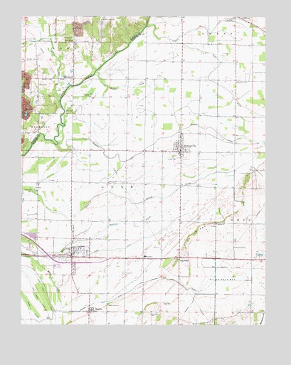
Richland City, IN USGS Topographic Map
Click on map above to begin viewing in our Map Viewer.

This topographic map contains these locations and features:
Feature Name Type Latitude Longitude GNIS ID View Map
Baker Creek CemeteryCemeteryN37.8837°W87.2053°430427View Map
Boyd CemeteryCemeteryN37.8837°W87.1769°431423View Map
Brauns Airport (historical)AirportN37.9100°W87.1828°449321View Map
Broshears CemeteryCemeteryN37.9920°W87.2236°431590View Map
Brown Chapel CemeteryCemeteryN37.9989°W87.2078°431608View Map
BullocktownPopulated PlaceN37.9748°W87.2228°431797View Map
Caney CreekStreamN37.9650°W87.2300°432109View Map
Ebenezer ChurchChurchN37.9328°W87.2044°433973View Map
EurekaPopulated PlaceN37.8806°W87.2150°434247View Map
Friendship CemeteryCemeteryN37.9367°W87.1656°434857View Map
Glendale CemeteryCemeteryN37.9298°W87.2444°435110View Map
Graff CemeteryCemeteryN37.9617°W87.2225°435273View Map
Gwaltney Memorial CemeteryCemeteryN37.9992°W87.1442°435566View Map
HatfieldPopulated PlaceN37.9025°W87.2242°435871View Map
Hatfield Census Designated PlaceCensusN37.9030°W87.2217°2629886View Map
Hatfield DrainStreamN37.9078°W87.2242°435875View Map
Hatfield Fire DepartmentBuildingN37.9021°W87.2167°2626604View Map
Hooppole DitchCanalN37.9523°W87.1711°436412View Map
Lake DrainStreamN37.9906°W87.1706°437527View Map
Long Pond DitchCanalN37.8914°W87.2394°438279View Map
Luce Elementary SchoolSchoolN37.9470°W87.1703°447098View Map
Luce Township Fire Department Station 2BuildingN37.9443°W87.1687°2626606View Map
Luce Township Volunteer Fire Department Station 1BuildingN37.9022°W87.2167°2626613View Map
McCoy DrainCanalN37.9300°W87.1694°438822View Map
MidwayPopulated PlaceN37.9995°W87.1383°439126View Map
Mount Zion ChurchChurchN37.9162°W87.1497°439740View Map
Muddy CreekStreamN37.9775°W87.2111°439853View Map
New HopePopulated PlaceN37.9898°W87.2225°440058View Map
Renshaw AirportAirportN37.8980°W87.2003°2677055View Map
Richardson CemeteryCemeteryN37.8795°W87.1833°441951View Map
Richland CityPopulated PlaceN37.9453°W87.1678°441965View Map
Rose Pond DitchCanalN37.8884°W87.2433°442300View Map
Sand RidgePopulated PlaceN37.9025°W87.1686°442984View Map
Sand RidgeRidgeN37.9112°W87.1622°442985View Map
Sweezer DitchCanalN37.9950°W87.1589°444488View Map
Tower DitchCanalN37.9081°W87.1922°444823View Map
Town of RichlandCivilN37.9462°W87.1690°2546908View Map
Township of LuceCivilN37.9120°W87.2008°453584View Map
Warren CemeteryCemeteryN37.9723°W87.2408°445480View Map
Willow Pond BedFlatN37.8931°W87.1444°446107View Map
Willow Pond DitchCanalN37.8887°W87.1944°446108View Map

Note: Coordinates in the location and feature list above are referenced to NAD83 datum.


Copyright (C) 2008-2025 Ryan Niemi / Sunset Dynamics ... All Rights Reserved