TopoQuest Logo
Do you find TopoQuest useful?
Help keep TopoQuest running and adding new maps/features by donating!
Bitcoin:  19c7KJd3qBynnjoSw5npx9KScwjBe4ifkT
Litecoin:  LXs6TkuXGGXo1vDsWCkWVdjQX94eUKd6ui
Home View Maps Find Maps Find Places Resources & Links


Rockport, Indiana Topographic Map

USGS Map Title: Rockport, IN
USGS Map MRC: 37087H1
DRG (GeoTIFF) Download: o37087h1.tif


Neighboring USGS Topographic Map Quads:


  De Gonia Springs, IN  
38087A2
 

  Chrisney, IN  
38087A1
 

  Santa Claus, IN  
38086A8
 

  Richland City, IN  
37087H2
 

  Rockport, IN  
37087H1
 

  Lewisport, KY  
37086H8
 

  Owensboro West, KY  
37087G2
 

  Owensboro East, KY  
37087G1
 

  Maceo, KY  
37086G8


Map MRC Location:

N38°
W88°
N38°
W87°
H8 H7 H6 H5 H4 H3 H2 H1
G8 G7 G6 G5 G4 G3 G2 G1
F8 F7 F6 F5 F4 F3 F2 F1
E8 E7 E6 E5 E4 E3 E2 E1
D8 D7 D6 D5 D4 D3 D2 D1
C8 C7 C6 C5 C4 C3 C2 C1
B8 B7 B6 B5 B4 B3 B2 B1
A8 A7 A6 A5 A4 A3 A2 A1
N37°
W88°
N37°
W87°

Rockport, IN USGS 1:24K Topographic Map Preview:
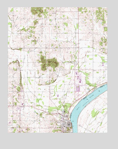
Rockport, IN USGS Topographic Map
Click on map above to begin viewing in our Map Viewer.

This topographic map contains these locations and features:
Feature Name Type Latitude Longitude GNIS ID View Map
CentervillePopulated PlaceN37.9942°W87.0633°432345View Map
City of RockportCivilN37.8899°W87.0538°2396408View Map
Coal KnobsSummitN37.9437°W87.0708°432709View Map
Crossroad ChurchChurchN37.9595°W87.0767°433191View Map
Fairview ChurchChurchN37.9801°W87.0011°434330View Map
Fisher KnobsSummitN37.9956°W87.0900°434522View Map
Garrett CreekStreamN37.8773°W87.0733°434972View Map
Hackleman CemeteryCemeteryN37.9667°W87.0911°435582View Map
Hanging RockSummitN37.8848°W87.0458°448913View Map
Highland ChurchChurchN37.9867°W87.0061°436159View Map
Honey CreekStreamN37.9173°W87.0161°436379View Map
Huffman DitchStreamN37.9117°W87.0906°436588View Map
Hurricane CreekStreamN37.8803°W87.1047°436648View Map
Kerr CemeteryCemeteryN37.9592°W87.1083°437264View Map
Lake MillPopulated PlaceN37.9378°W87.1097°437534View Map
Lincoln Pioneer VillagePopulated PlaceN37.8800°W87.0583°437921View Map
McCoy CemeteryCemeteryN37.9612°W87.0747°438818View Map
New Bethel ChurchChurchN37.9373°W87.0172°440020View Map
Nix HillSummitN37.9834°W87.0892°440184View Map
Pinkston CemeteryCemeteryN37.9953°W87.0561°441174View Map
Pleasant Valley CemeteryCemeteryN37.9942°W87.1183°441321View Map
ReoPopulated PlaceN37.9014°W87.1094°441904View Map
RitchiePopulated PlaceN37.9598°W87.0389°446757View Map
Rock HillPopulated PlaceN37.9451°W87.0400°442201View Map
RockportPopulated PlaceN37.8831°W87.0494°442223View Map
Rockport Ohio Township Volunteer Fire DepartmentBuildingN37.8916°W87.0515°2625872View Map
Rockport Police DepartmentBuildingN37.8830°W87.0492°2758092View Map
Saint Bernard CemeteryCemeteryN37.8962°W87.0486°442498View Map
Shiloh ChurchChurchN37.8795°W87.1192°443389View Map
SilverdalePopulated PlaceN37.9159°W87.0714°443516View Map
Spencer County SheriffBuildingN37.8840°W87.0466°2758138View Map
Stateler CemeteryCemeteryN37.9559°W87.0839°444096View Map
Township of OhioCivilN37.8833°W87.0942°453684View Map
Vance LakeReservoirN37.9176°W87.0232°445223View Map
Whitehouse CemeteryCemeteryN37.9670°W87.0330°445969View Map
Zoar CemeteryCemeteryN37.9662°W87.0625°446488View Map

Note: Coordinates in the location and feature list above are referenced to NAD83 datum.


Copyright (C) 2008-2024 Ryan Niemi / Sunset Dynamics ... All Rights Reserved