TopoQuest Logo
Do you find TopoQuest useful?
Help keep TopoQuest running and adding new maps/features by donating!
Bitcoin:  19c7KJd3qBynnjoSw5npx9KScwjBe4ifkT
Litecoin:  LXs6TkuXGGXo1vDsWCkWVdjQX94eUKd6ui
Home View Maps Find Maps Find Places Resources & Links


Stockport, Ohio Topographic Map

USGS Map Title: Stockport, OH
USGS Map MRC: 39081E7
DRG (GeoTIFF) Download: o39081e7.tif


Neighboring USGS Topographic Map Quads:


  Rokeby Lock, OH  
39081F8
 

  McConnelsville, OH  
39081F7
 

  Reinersville, OH  
39081F6
 

  Ringgold, OH  
39081E8
 

  Stockport, OH  
39081E7
 

  Beverly, OH  
39081E6
 

  Amesville, OH  
39081D8
 

  Chesterhill, OH  
39081D7
 

  Watertown, OH  
39081D6


Map MRC Location:

N40°
W82°
N40°
W81°
H8 H7 H6 H5 H4 H3 H2 H1
G8 G7 G6 G5 G4 G3 G2 G1
F8 F7 F6 F5 F4 F3 F2 F1
E8 E7 E6 E5 E4 E3 E2 E1
D8 D7 D6 D5 D4 D3 D2 D1
C8 C7 C6 C5 C4 C3 C2 C1
B8 B7 B6 B5 B4 B3 B2 B1
A8 A7 A6 A5 A4 A3 A2 A1
N39°
W82°
N39°
W81°

Stockport, OH USGS 1:24K Topographic Map Preview:
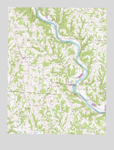
Stockport, OH USGS Topographic Map
Click on map above to begin viewing in our Map Viewer.

This topographic map contains these locations and features:
Feature Name Type Latitude Longitude GNIS ID View Map
Anderson School (historical)SchoolN39.5559°W81.8287°1051199View Map
Bailey CemeteryCemeteryN39.5937°W81.8210°1964200View Map
Bailey ChurchChurchN39.5937°W81.8210°1037574View Map
Bain CemeteryCemeteryN39.5860°W81.8610°1037579View Map
Bald Eagle FieldAirportN39.5557°W81.7840°1083031View Map
Bald Eagle RunStreamN39.5520°W81.7876°1075299View Map
Big Bottom School (historical)SchoolN39.5301°W81.7682°1051204View Map
Big Bottom State Memorial ParkParkN39.5334°W81.7740°1038000View Map
Blackemar CemeteryCemeteryN39.5329°W81.7523°1038089View Map
Brick Church (historical)ChurchN39.5673°W81.7790°1068863View Map
Brick Church CemeteryCemeteryN39.5689°W81.7794°1038299View Map
Browns RunStreamN39.5390°W81.8679°1075451View Map
Chadwick (historical)Populated PlaceN39.5123°W81.7504°1051203View Map
Doudna RunStreamN39.6176°W81.8390°1075737View Map
Dry RunStreamN39.5934°W81.8479°1039816View Map
Ellis CemeteryCemeteryN39.5231°W81.7932°1040144View Map
Ellis School (historical)SchoolN39.5231°W81.7935°1051197View Map
Friends Burial GroundCemeteryN39.5790°W81.8607°1040684View Map
Goshen CreekStreamN39.5123°W81.8615°1075940View Map
Halley PondReservoirN39.5618°W81.8334°1078099View Map
Halley Pond DamDamN39.5617°W81.8349°1078098View Map
Henry HollowValleyN39.5515°W81.7815°1041494View Map
Hooks RunStreamN39.5853°W81.7840°1041748View Map
HooksburgPopulated PlaceN39.5837°W81.7837°1064859View Map
Hooksburg Post Office (historical)Post OfficeN39.5834°W81.7832°2037875View Map
Hopedale School (historical)SchoolN39.6112°W81.8743°1051196View Map
Hopewell CemeteryCemeteryN39.6223°W81.7887°1041770View Map
Hopewell CemeteryCemeteryN39.6106°W81.8734°1964209View Map
Hopewell ChurchChurchN39.6109°W81.8737°1041776View Map
Hopewell Church (historical)ChurchN39.6226°W81.7887°1071078View Map
Hossom School (historical)SchoolN39.5820°W81.7562°1071077View Map
Infirmary CemeteryCemeteryN39.6098°W81.8154°1964210View Map
Lick RunStreamN39.5273°W81.8310°1042539View Map
Lightner CemeteryCemeteryN39.5308°W81.8211°1042563View Map
Lightners School (historical)SchoolN39.5312°W81.8215°1071076View Map
LovellPopulated PlaceN39.6028°W81.8149°1068267View Map
Manns RunStreamN39.5895°W81.7871°1042925View Map
Marlane FarmLocaleN39.6239°W81.7706°2628468View Map
McCoy RidgeRidgeN39.5498°W81.7596°1043159View Map
McPherson RunStreamN39.5123°W81.8596°1043185View Map
Morgan CountyCivilN39.6204°W81.8527°1074070View Map
Muskingum River Lock and Dam NumberReservoirN39.5467°W81.7882°1078831View Map
Muskingum River Lock and Dam Number SixDamN39.5475°W81.7882°1078830View Map
Newton Ridge School (historical)SchoolN39.5801°W81.8004°1051200View Map
Patterson RidgeRidgeN39.5715°W81.7635°1044319View Map
Patterson School (historical)SchoolN39.5648°W81.7682°1051205View Map
PennsvillePopulated PlaceN39.5753°W81.8554°1049073View Map
Pennsville CemeteryCemeteryN39.5767°W81.8521°1964220View Map
Pennsville Church of ChristChurchN39.5748°W81.8551°1068935View Map
Pennsville Elementary SchoolSchoolN39.5731°W81.8521°1051194View Map
Pennsville HeliportAirportN39.5731°W81.8549°1082950View Map
Pennsville Post OfficePost OfficeN39.5751°W81.8554°2038197View Map
Pennsville United Methodist ChurchChurchN39.5753°W81.8540°1068936View Map
Pennsville Volunteer Fire DepartmentBuildingN39.5749°W81.8547°2550425View Map
Ringgold Post Office (historical)Post OfficeN39.5903°W81.8457°2037879View Map
Scott RunStreamN39.5026°W81.8043°1046066View Map
Sherwood Church (historical)ChurchN39.6065°W81.8124°1051202View Map
Sherwood RunStreamN39.6084°W81.8154°1046208View Map
Simpson RunStreamN39.5820°W81.8299°1046295View Map
Simpson School (historical)SchoolN39.5931°W81.8635°1051195View Map
Spencer School (historical)SchoolN39.5984°W81.8185°1051201View Map
StockportPopulated PlaceN39.5484°W81.7929°1070952View Map
Stockport CemeteryCemeteryN39.5473°W81.7968°1964224View Map
Stockport Fire and Emergency Medical Services DepartmentBuildingN39.5494°W81.7959°2550554View Map
Stockport Post OfficePost OfficeN39.5487°W81.7929°2037869View Map
Taylor HollowValleyN39.5973°W81.7949°1046968View Map
ToddsPopulated PlaceN39.5248°W81.8468°1063062View Map
Todds Methodist ChurchChurchN39.5256°W81.8460°1068960View Map
Todds Post Office (historical)Post OfficeN39.5251°W81.8471°2038225View Map
Township of PennCivilN39.5711°W81.8712°1086693View Map
Township of WindsorCivilN39.5404°W81.7657°1086695View Map
Turkey RunStreamN39.5426°W81.7901°1047205View Map
Village of StockportCivilN39.5489°W81.7944°2399904View Map
West Union School (historical)SchoolN39.5331°W81.8582°1051193View Map
Windsor Elementary SchoolSchoolN39.5481°W81.7962°1051198View Map
WYBH-FM (McConnelsville)TowerN39.5567°W81.8515°1083864View Map

Note: Coordinates in the location and feature list above are referenced to NAD83 datum.


Copyright (C) 2008-2025 Ryan Niemi / Sunset Dynamics ... All Rights Reserved