TopoQuest Logo
Do you find TopoQuest useful?
Help keep TopoQuest running and adding new maps/features by donating!
Bitcoin:  19c7KJd3qBynnjoSw5npx9KScwjBe4ifkT
Litecoin:  LXs6TkuXGGXo1vDsWCkWVdjQX94eUKd6ui
Home View Maps Find Maps Find Places Resources & Links


Roaring Spring, Pennsylvania Topographic Map

USGS Map Title: Roaring Spring, PA
USGS Map MRC: 40078C4
DRG (GeoTIFF) Download: o40078c4.tif


Neighboring USGS Topographic Map Quads:


  Cresson, PA  
40078D5
 

  Hollidaysburg, PA  
40078D4
 

  Frankstown, PA  
40078D3
 

  Blue Knob, PA  
40078C5
 

  Roaring Spring, PA  
40078C4
 

  Martinsburg, PA  
40078C3
 

  Alum Bank, PA  
40078B5
 

  New Enterprise, PA  
40078B4
 

  Hopewell, PA  
40078B3


Map MRC Location:

N41°
W79°
N41°
W78°
H8 H7 H6 H5 H4 H3 H2 H1
G8 G7 G6 G5 G4 G3 G2 G1
F8 F7 F6 F5 F4 F3 F2 F1
E8 E7 E6 E5 E4 E3 E2 E1
D8 D7 D6 D5 D4 D3 D2 D1
C8 C7 C6 C5 C4 C3 C2 C1
B8 B7 B6 B5 B4 B3 B2 B1
A8 A7 A6 A5 A4 A3 A2 A1
N40°
W79°
N40°
W78°

Roaring Spring, PA USGS 1:24K Topographic Map Preview:
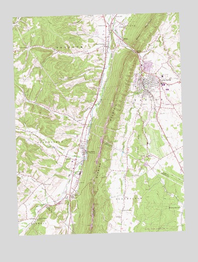
Roaring Spring, PA USGS Topographic Map
Click on map above to begin viewing in our Map Viewer.

This topographic map contains these locations and features:
Feature Name Type Latitude Longitude GNIS ID View Map
Albright ChurchChurchN40.3229°W78.4047°1168119View Map
Albright Church of the Brethren CemeteryCemeteryN40.3224°W78.4049°2776323View Map
Bakers SummitPopulated PlaceN40.2626°W78.4214°1168615View Map
Beaverdam CreekStreamN40.2931°W78.4478°1169061View Map
Boiling Spring RunStreamN40.2717°W78.4661°1169954View Map
Borough of Roaring SpringCivilN40.3348°W78.3960°1214945View Map
Brooks MillPopulated PlaceN40.3737°W78.4228°1170337View Map
Cabbage CreekStreamN40.3304°W78.4092°1170851View Map
Chimney Rock Beagle ClubLocaleN40.3617°W78.4570°1213171View Map
ClaysburgPopulated PlaceN40.2967°W78.4497°1198275View Map
Claysburg - Kimmel High SchoolSchoolN40.2849°W78.4523°1205646View Map
Claysburg Census Designated PlaceCensusN40.2897°W78.4482°2389329View Map
Claysburg Post OfficePost OfficeN40.2942°W78.4483°2777381View Map
Claysburg Union CemeteryCemeteryN40.2909°W78.4542°2776334View Map
Claysburg Volunteer Fire Department Station 70BuildingN40.2950°W78.4545°2645077View Map
Cotton TownPopulated PlaceN40.2795°W78.4808°1172491View Map
Davis Family CemeteryCemeteryN40.3547°W78.4440°2776338View Map
Dodsons GraveyardCemeteryN40.3402°W78.4833°2776340View Map
East FreedomPopulated PlaceN40.3576°W78.4297°1173813View Map
East Freedom Census Designated PlaceCensusN40.3573°W78.4366°2631260View Map
East Freedom Post OfficePost OfficeN40.3581°W78.4286°2777390View Map
Ebeneza ChurchChurchN40.3004°W78.4506°1173943View Map
Fairview CemeteryCemeteryN40.3049°W78.4544°2776345View Map
Feather CemeteryCemeteryN40.3389°W78.4585°2776346View Map
Franklin D Roosevelt Elementary SchoolSchoolN40.2848°W78.4525°1213902View Map
Freedom Township Volunteer Fire Company Station 40BuildingN40.3597°W78.4295°2644997View Map
Friendship Fire Company Station 60BuildingN40.3354°W78.3938°2645220View Map
FriesvillePopulated PlaceN40.2948°W78.4622°1175273View Map
Greenfield CemeteryCemeteryN40.2600°W78.4850°2776084View Map
Greenfield ChurchChurchN40.2592°W78.4858°1176152View Map
Greenlawn CemeteryCemeteryN40.3389°W78.4002°2776351View Map
Iron Masters Country ClubLocaleN40.2826°W78.4131°1213241View Map
LeamersvillePopulated PlaceN40.3684°W78.4270°1179087View Map
Long Family CemeteryCemeteryN40.2513°W78.4221°2776100View Map
Lower Claar ChurchChurchN40.2856°W78.4983°1180012View Map
Lower Claar Church of the Brethren CemeteryCemeteryN40.2859°W78.4986°2776359View Map
McKeePopulated PlaceN40.3598°W78.4172°1180735View Map
McKee GapGapN40.3526°W78.4078°1190982View Map
Nason HospitalHospitalN40.3389°W78.3885°1182174View Map
Old Claysburg CemeteryCemeteryN40.2913°W78.4532°2776369View Map
Ore HillPopulated PlaceN40.2937°W78.4008°1183026View Map
Ore Hill RidgeRidgeN40.2984°W78.4072°1183027View Map
Pawpaw RunStreamN40.3442°W78.4308°1183397View Map
Pine RunStreamN40.2851°W78.4561°1183890View Map
Plum CreekStreamN40.3520°W78.4072°1168017View Map
Polecat RunStreamN40.3220°W78.4400°1184194View Map
Queen StationLocaleN40.2595°W78.4878°1184544View Map
Roaring SpringPopulated PlaceN40.3359°W78.3908°1185189View Map
Roaring SpringSpringN40.3331°W78.4008°1202160View Map
Roaring Spring Post OfficePost OfficeN40.3353°W78.4004°2777427View Map
Roaring Spring QuarryMineN40.3481°W78.3997°2724978View Map
RodmanPopulated PlaceN40.3412°W78.4003°1201284View Map
Rodman CemeteryCemeteryN40.3425°W78.4067°2776374View Map
Saint Annes ChurchChurchN40.2795°W78.4542°1185774View Map
Shawnee ParkParkN40.3284°W78.4072°1187406View Map
Smith CornerPopulated PlaceN40.3576°W78.4889°1204668View Map
Smoky RunStreamN40.2679°W78.4770°1187918View Map
South Dry RunStreamN40.3573°W78.4278°1188055View Map
South Poplar RunStreamN40.2931°W78.4478°1193412View Map
SproulPopulated PlaceN40.2726°W78.4606°1188317View Map
Sproul Union CemeteryCemeteryN40.2733°W78.4585°2776390View Map
Steam Pump DamDamN40.2967°W78.4197°1194706View Map
Stowberger CemeteryCemeteryN40.3376°W78.3758°1188832View Map
Township of FreedomCivilN40.3618°W78.4661°1215961View Map
Township of TaylorCivilN40.3280°W78.3829°1215968View Map
VicksburgPopulated PlaceN40.3676°W78.4150°1190396View Map
Vicksburg Grace Brethren Church CemeteryCemeteryN40.3666°W78.4155°2776393View Map
Weynant SpringSpringN40.2940°W78.4467°1202440View Map
WKMC-AM (Roaring Spring)TowerN40.3240°W78.3942°1200399View Map

Note: Coordinates in the location and feature list above are referenced to NAD83 datum.


Copyright (C) 2008-2024 Ryan Niemi / Sunset Dynamics ... All Rights Reserved