TopoQuest Logo
Do you find TopoQuest useful?
Help keep TopoQuest running and adding new maps/features by donating!
Bitcoin:  19c7KJd3qBynnjoSw5npx9KScwjBe4ifkT
Litecoin:  LXs6TkuXGGXo1vDsWCkWVdjQX94eUKd6ui
Home View Maps Find Maps Find Places Resources & Links


New Enterprise, Pennsylvania Topographic Map

USGS Map Title: New Enterprise, PA
USGS Map MRC: 40078B4
DRG (GeoTIFF) Download: o40078b4.tif


Neighboring USGS Topographic Map Quads:


  Blue Knob, PA  
40078C5
 

  Roaring Spring, PA  
40078C4
 

  Martinsburg, PA  
40078C3
 

  Alum Bank, PA  
40078B5
 

  New Enterprise, PA  
40078B4
 

  Hopewell, PA  
40078B3
 

  Bedford, PA  
40078A5
 

  Everett West, PA  
40078A4
 

  Everett East, PA  
40078A3


Map MRC Location:

N41°
W79°
N41°
W78°
H8 H7 H6 H5 H4 H3 H2 H1
G8 G7 G6 G5 G4 G3 G2 G1
F8 F7 F6 F5 F4 F3 F2 F1
E8 E7 E6 E5 E4 E3 E2 E1
D8 D7 D6 D5 D4 D3 D2 D1
C8 C7 C6 C5 C4 C3 C2 C1
B8 B7 B6 B5 B4 B3 B2 B1
A8 A7 A6 A5 A4 A3 A2 A1
N40°
W79°
N40°
W78°

New Enterprise, PA USGS 1:24K Topographic Map Preview:
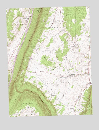
New Enterprise, PA USGS Topographic Map
Click on map above to begin viewing in our Map Viewer.

This topographic map contains these locations and features:
Feature Name Type Latitude Longitude GNIS ID View Map
Barley ChurchChurchN40.2342°W78.4264°1168722View Map
Barley Lutheran Church CemeteryCemeteryN40.2343°W78.4277°2776040View Map
BrumbaughPopulated PlaceN40.1795°W78.4706°1203175View Map
Burger CemeteryCemeteryN40.1451°W78.4270°1170708View Map
CoveburgLocaleN40.2142°W78.4033°1207178View Map
Dunning MountainSummitN40.2456°W78.4461°1192385View Map
Hetrick CemeteryCemeteryN40.1390°W78.3897°1176925View Map
Hickory Bottom CreekStreamN40.1929°W78.3764°1176949View Map
Holsinger CemeteryCemeteryN40.2461°W78.4239°2776089View Map
Holsinger ChurchChurchN40.2459°W78.4233°1177236View Map
Keagy DamDamN40.2092°W78.3756°1178263View Map
Keagy HillSummitN40.1606°W78.4295°1178264View Map
KingPopulated PlaceN40.2440°W78.4642°1178472View Map
Koontz ChurchChurchN40.1401°W78.3972°1178648View Map
Koontz Church of the Brethren CemeteryCemeteryN40.1402°W78.3983°2776098View Map
LafayettevillePopulated PlaceN40.2017°W78.4536°1178757View Map
LoysburgPopulated PlaceN40.1609°W78.3750°1180053View Map
Loysburg CemeteryCemeteryN40.1641°W78.3777°2776101View Map
Loysburg Hill CemeteryCemeteryN40.1600°W78.3833°2776102View Map
MariaPopulated PlaceN40.2179°W78.4070°1180405View Map
Middle RidgeRidgeN40.1890°W78.4395°1181040View Map
New EnterprisePopulated PlaceN40.1704°W78.4070°1182314View Map
New Enterprise CemeteryCemeteryN40.1742°W78.4133°2776126View Map
New Enterprise Post OfficePost OfficeN40.1696°W78.4084°2777465View Map
Northern Bedford County High SchoolSchoolN40.1776°W78.3795°1182667View Map
Potter CreekStreamN40.1887°W78.3753°1184334View Map
Potter Creek CemeteryCemeteryN40.2040°W78.3981°1184336View Map
Saint Johns ChurchChurchN40.1976°W78.3933°1186100View Map
Saint Mark's CemeteryCemeteryN40.2376°W78.4674°2776154View Map
Saint Marks Union ChurchChurchN40.2373°W78.4670°1186344View Map
SalemvillePopulated PlaceN40.1484°W78.4328°1186862View Map
Salemville CemeteryCemeteryN40.1541°W78.4390°2776157View Map
Shaefer OverlookLocaleN40.1751°W78.4831°1207017View Map
Snyder CemeteryCemeteryN40.2177°W78.4195°2776165View Map
Southern Cove Emergency Medical ServicesBuildingN40.1721°W78.4256°2719502View Map
Southern Cove Volunteer Fire Company - Station 41BuildingN40.1695°W78.4093°2645531View Map
State Game Lands Number 41ParkN40.2395°W78.3950°1188514View Map
Texas CornerPopulated PlaceN40.1320°W78.4011°1204807View Map
The KettleBasinN40.1631°W78.4767°1189412View Map
Three Springs RunStreamN40.1709°W78.3758°1189548View Map
Township of BloomfieldCivilN40.2464°W78.4205°1215888View Map
Township of South WoodburyCivilN40.1606°W78.4158°1215907View Map
WatersidePopulated PlaceN40.1898°W78.3758°1988990View Map
Waterside CemeteryCemeteryN40.1890°W78.3802°2776177View Map

Note: Coordinates in the location and feature list above are referenced to NAD83 datum.


Copyright (C) 2008-2024 Ryan Niemi / Sunset Dynamics ... All Rights Reserved