TopoQuest Logo
Do you find TopoQuest useful?
Help keep TopoQuest running and adding new maps/features by donating!
Bitcoin:  19c7KJd3qBynnjoSw5npx9KScwjBe4ifkT
Litecoin:  LXs6TkuXGGXo1vDsWCkWVdjQX94eUKd6ui
Home View Maps Find Maps Find Places Resources & Links


Rolesville, North Carolina Topographic Map

USGS Map Title: Rolesville, NC
USGS Map MRC: 35078H4
DRG (GeoTIFF) Download: o35078h4.tif


Neighboring USGS Topographic Map Quads:


  Grissom, NC  
36078A5
 

  Franklinton, NC  
36078A4
 

  Louisburg, NC  
36078A3
 

  Wake Forest, NC  
35078H5
 

  Rolesville, NC  
35078H4
 

  Bunn West, NC  
35078H3
 

  Raleigh East, NC  
35078G5
 

  Knightdale, NC  
35078G4
 

  Zebulon, NC  
35078G3


Map MRC Location:

N36°
W79°
N36°
W78°
H8 H7 H6 H5 H4 H3 H2 H1
G8 G7 G6 G5 G4 G3 G2 G1
F8 F7 F6 F5 F4 F3 F2 F1
E8 E7 E6 E5 E4 E3 E2 E1
D8 D7 D6 D5 D4 D3 D2 D1
C8 C7 C6 C5 C4 C3 C2 C1
B8 B7 B6 B5 B4 B3 B2 B1
A8 A7 A6 A5 A4 A3 A2 A1
N35°
W79°
N35°
W78°

Rolesville, NC USGS 1:24K Topographic Map Preview:
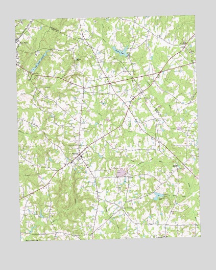
Rolesville, NC USGS Topographic Map
Click on map above to begin viewing in our Map Viewer.

This topographic map contains these locations and features:
Feature Name Type Latitude Longitude GNIS ID View Map
Austin CreekStreamN35.9604°W78.4886°1018878View Map
BarhamPopulated PlaceN35.9421°W78.4042°980553View Map
Beulah ChurchChurchN35.9110°W78.3942°981273View Map
Blackley PondReservoirN35.8885°W78.4847°999668View Map
Blackley Pond DamDamN35.8885°W78.4847°999669View Map
Cedar ForkStreamN35.9168°W78.3897°1019576View Map
Clement Academy (historical)SchoolN35.9568°W78.4353°1953920View Map
Corinth United ChurchChurchN35.9754°W78.4406°983568View Map
Fowlers CrossroadsPopulated PlaceN35.8927°W78.4292°985350View Map
Fowlers Mill CreekStreamN35.8996°W78.3817°985351View Map
Freemans Mill (historical)LocaleN35.9438°W78.4794°1953921View Map
Harris ChapelChurchN35.9793°W78.3781°1020627View Map
Harris CrossroadsPopulated PlaceN35.9824°W78.3822°986448View Map
LassiterPopulated PlaceN35.9102°W78.4244°988153View Map
Mitchell CemeteryCemeteryN35.9368°W78.3808°990092View Map
Mitchell MillpondReservoirN35.9146°W78.3881°990097View Map
Mitchell PondReservoirN35.9268°W78.3764°999742View Map
Mitchell PondReservoirN35.9765°W78.4583°990098View Map
Mitchell Pond DamDamN35.9268°W78.3764°999743View Map
Mitchells Mill (historical)LocaleN35.9146°W78.3878°1953922View Map
Mitchells Mill (historical)LocaleN35.9765°W78.4592°1953923View Map
Moores PondReservoirN35.9790°W78.4214°990206View Map
Moores Pond DamDamN35.9785°W78.4214°999835View Map
Mount Calvary ChurchChurchN35.8949°W78.4783°990335View Map
Oak Grove ChurchChurchN35.9879°W78.4528°1021691View Map
Penny Hill LakeReservoirN35.8990°W78.3997°992037View Map
Penny Hill Lake DamDamN35.8990°W78.3997°999704View Map
Perry CreekStreamN35.9304°W78.3961°992052View Map
RolesvillePopulated PlaceN35.9232°W78.4575°993655View Map
Rolesville Baptist Church CemeteryCemeteryN35.9379°W78.4557°993656View Map
Rolesville Elementary SchoolSchoolN35.9190°W78.4628°1002816View Map
Rolesville Emergency Medical Services Station 6BuildingN35.9218°W78.4567°2720497View Map
Rolesville Police DepartmentBuildingN35.9171°W78.4697°2769584View Map
Rolesville Post OfficePost OfficeN35.9209°W78.4668°2455257View Map
Rolesville Rural Fire DepartmentBuildingN35.9225°W78.4573°2639507View Map
Shearon LakeReservoirN35.9635°W78.4164°999821View Map
Shearon Lake DamDamN35.9635°W78.4164°999820View Map
Town of RolesvilleCivilN35.9250°W78.4662°2407237View Map
Township of Wake ForestCivilN35.9359°W78.4884°1027276View Map
Wake Forest Municipal DamDamN35.9704°W78.4878°999825View Map
Wake Forest ReservoirReservoirN35.9704°W78.4878°996679View Map
Watkins PondReservoirN35.8802°W78.4931°999645View Map
Watkins Pond DamDamN35.8802°W78.4931°999644View Map

Note: Coordinates in the location and feature list above are referenced to NAD83 datum.


Copyright (C) 2008-2025 Ryan Niemi / Sunset Dynamics ... All Rights Reserved