TopoQuest Logo
Do you find TopoQuest useful?
Help keep TopoQuest running and adding new maps/features by donating!
Bitcoin:  19c7KJd3qBynnjoSw5npx9KScwjBe4ifkT
Litecoin:  LXs6TkuXGGXo1vDsWCkWVdjQX94eUKd6ui
Home View Maps Find Maps Find Places Resources & Links


Rose Springs, Washington Topographic Map

USGS Map Title: Rose Springs, WA
USGS Map MRC: 46117C5
DRG (GeoTIFF) Download: o46117c5.tif


Neighboring USGS Topographic Map Quads:


  Zumwalt, WA  
46117D6
 

  Pomeroy, WA  
46117D5
 

  Alpowa Ridge, WA  
46117D4
 

  Hopkins Ridge, WA  
46117C6
 

  Rose Springs, WA  
46117C5
 

  Peola, WA  
46117C4
 

  Panjab Creek, WA  
46117B6
 

  Stentz Spring, WA  
46117B5
 

  Pinkham Butte, WA  
46117B4


Map MRC Location:

N47°
W118°
N47°
W117°
H8 H7 H6 H5 H4 H3 H2 H1
G8 G7 G6 G5 G4 G3 G2 G1
F8 F7 F6 F5 F4 F3 F2 F1
E8 E7 E6 E5 E4 E3 E2 E1
D8 D7 D6 D5 D4 D3 D2 D1
C8 C7 C6 C5 C4 C3 C2 C1
B8 B7 B6 B5 B4 B3 B2 B1
A8 A7 A6 A5 A4 A3 A2 A1
N46°
W118°
N46°
W117°

Rose Springs, WA USGS 1:24K Topographic Map Preview:
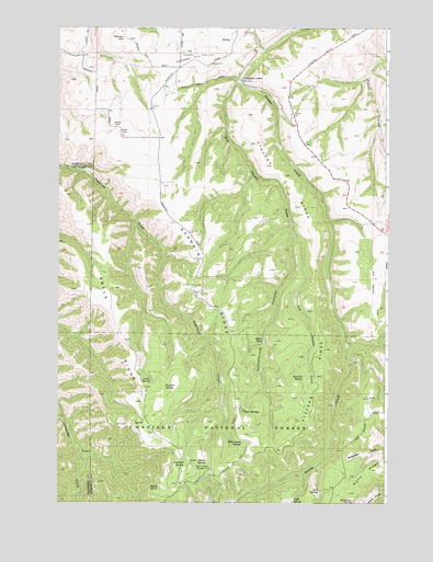
Rose Springs, WA USGS Topographic Map
Click on map above to begin viewing in our Map Viewer.

This topographic map contains these locations and features:
Feature Name Type Latitude Longitude GNIS ID View Map
Abels PointCliffN46.2538°W117.5863°1502926View Map
Abels RidgeRidgeN46.2926°W117.5991°1513054View Map
Alder Thicket CampgroundLocaleN46.2588°W117.5669°1502973View Map
Alder Thicket SpringSpringN46.2605°W117.5683°1511485View Map
Arbothknott CanyonValleyN46.3199°W117.5363°1503048View Map
Baker PondLakeN46.2928°W117.5468°1503132View Map
Calloway HillSummitN46.3677°W117.5677°1503717View Map
Cold SpringSpringN46.2530°W117.5257°1504063View Map
Columbia CenterLocaleN46.3613°W117.5555°1504079View Map
Dry Pataha CreekStreamN46.3613°W117.5557°1504570View Map
Government SpringSpringN46.2657°W117.5548°1505206View Map
Horseshoe SpringSpringN46.2500°W117.5130°1505629View Map
Lanzie SpringSpringN46.2823°W117.5895°1506078View Map
Martin RidgeRidgeN46.2527°W117.5146°1506488View Map
Oliphant SpringSpringN46.2602°W117.5768°1507166View Map
Pataha CampgroundLocaleN46.2918°W117.5155°1507320View Map
Red Hill Gravel PitMineN46.3535°W117.5905°1514017View Map
Rose SpringSpringN46.2748°W117.5542°1514018View Map
Rose SpringsPopulated PlaceN46.2752°W117.5543°1512621View Map
Ruchert SpringSpringN46.2804°W117.5842°1507955View Map
Sawmill SpringSpringN46.2830°W117.5318°1508135View Map
Scoggin RidgeRidgeN46.2979°W117.5594°1508166View Map
Stevens RidgeRidgeN46.3135°W117.5271°1508732View Map
Tatman MountainSummitN46.3721°W117.5985°1512715View Map
Twin SpringSpringN46.2502°W117.5360°1510748View Map
Welch RidgeRidgeN46.2513°W117.5046°1509360View Map

Note: Coordinates in the location and feature list above are referenced to NAD83 datum.


Copyright (C) 2008-2025 Ryan Niemi / Sunset Dynamics ... All Rights Reserved