TopoQuest Logo
Do you find TopoQuest useful?
Help keep TopoQuest running and adding new maps/features by donating!
Bitcoin:  19c7KJd3qBynnjoSw5npx9KScwjBe4ifkT
Litecoin:  LXs6TkuXGGXo1vDsWCkWVdjQX94eUKd6ui
Home View Maps Find Maps Find Places Resources & Links


Russellville, Indiana Topographic Map

USGS Map Title: Russellville, IN
USGS Map MRC: 39086G8
DRG (GeoTIFF) Download: o39086g8.tif


Neighboring USGS Topographic Map Quads:


  Alamo, IN  
39087H1
 

  New Market, IN  
39086H8
 

  Ladoga, IN  
39086H7
 

  Bellmore, IN  
39087G1
 

  Russellville, IN  
39086G8
 

  Roachdale, IN  
39086G7
 

  Mansfield, IN  
39087F1
 

  Clinton Falls, IN  
39086F8
 

  Greencastle, IN  
39086F7


Map MRC Location:

N40°
W87°
N40°
W86°
H8 H7 H6 H5 H4 H3 H2 H1
G8 G7 G6 G5 G4 G3 G2 G1
F8 F7 F6 F5 F4 F3 F2 F1
E8 E7 E6 E5 E4 E3 E2 E1
D8 D7 D6 D5 D4 D3 D2 D1
C8 C7 C6 C5 C4 C3 C2 C1
B8 B7 B6 B5 B4 B3 B2 B1
A8 A7 A6 A5 A4 A3 A2 A1
N39°
W87°
N39°
W86°

Russellville, IN USGS 1:24K Topographic Map Preview:
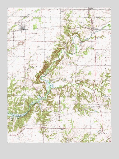
Russellville, IN USGS Topographic Map
Click on map above to begin viewing in our Map Viewer.

This topographic map contains these locations and features:
Feature Name Type Latitude Longitude GNIS ID View Map
4 Winds AerodromeAirportN39.8235°W86.8841°449323View Map
Bakesburg CemeteryCemeteryN39.8076°W86.9097°430441View Map
BlakesburgPopulated PlaceN39.8073°W86.9100°452150View Map
Durham AirportAirportN39.8540°W86.9630°2677065View Map
FincastlePopulated PlaceN39.8081°W86.8950°434481View Map
Forgey CemeteryCemeteryN39.8233°W86.9760°434669View Map
Grider CemeteryCemeteryN39.8470°W86.8925°435492View Map
Hebron CemeteryCemeteryN39.8389°W86.9643°435962View Map
James CemeteryCemeteryN39.8689°W86.9032°436919View Map
LaFollette CemeteryCemeteryN39.8610°W86.9137°437492View Map
Landes CemeteryCemeteryN39.8325°W86.9231°437601View Map
MortonPopulated PlaceN39.7631°W86.9364°439474View Map
Nicolas CemeteryCemeteryN39.8628°W86.9272°440169View Map
North Ramp CreekStreamN39.7998°W86.8917°440287View Map
ParkersburgPopulated PlaceN39.8734°W86.9028°449705View Map
Peffley CemeteryCemeteryN39.8281°W86.9292°440977View Map
Peters CreekStreamN39.8014°W86.9170°441054View Map
Pickle CemeteryCemeteryN39.7992°W86.8933°441103View Map
RaccoonPopulated PlaceN39.8562°W86.8964°441714View Map
Ramp CreekStreamN39.8000°W86.9481°441754View Map
RussellvillePopulated PlaceN39.8584°W86.9839°442418View Map
Russellville and Community Volunteer Fire DepartmentBuildingN39.8546°W86.9830°2626375View Map
Russellville Elementary SchoolSchoolN39.8584°W86.9856°447156View Map
Russellville Town Marshal's OfficeBuildingN39.8551°W86.9835°2758396View Map
Skillman CemeteryCemeteryN39.8437°W86.9119°443578View Map
South Ramp CreekStreamN39.7998°W86.8917°443843View Map
Sutherlin CemeteryCemeteryN39.8073°W86.9454°444443View Map
Town of RussellvilleCivilN39.8570°W86.9832°2396894View Map
Township of RussellCivilN39.8226°W86.9546°453817View Map
Union ChapelChurchN39.7637°W86.9564°445086View Map

Note: Coordinates in the location and feature list above are referenced to NAD83 datum.


Copyright (C) 2008-2025 Ryan Niemi / Sunset Dynamics ... All Rights Reserved