TopoQuest Logo
Do you find TopoQuest useful?
Help keep TopoQuest running and adding new maps/features by donating!
Bitcoin:  19c7KJd3qBynnjoSw5npx9KScwjBe4ifkT
Litecoin:  LXs6TkuXGGXo1vDsWCkWVdjQX94eUKd6ui
Home View Maps Find Maps Find Places Resources & Links


Roachdale, Indiana Topographic Map

USGS Map Title: Roachdale, IN
USGS Map MRC: 39086G7
DRG (GeoTIFF) Download: o39086g7.tif


Neighboring USGS Topographic Map Quads:


  New Market, IN  
39086H8
 

  Ladoga, IN  
39086H7
 

  New Ross, IN  
39086H6
 

  Russellville, IN  
39086G8
 

  Roachdale, IN  
39086G7
 

  North Salem, IN  
39086G6
 

  Clinton Falls, IN  
39086F8
 

  Greencastle, IN  
39086F7
 

  Coatesville, IN  
39086F6


Map MRC Location:

N40°
W87°
N40°
W86°
H8 H7 H6 H5 H4 H3 H2 H1
G8 G7 G6 G5 G4 G3 G2 G1
F8 F7 F6 F5 F4 F3 F2 F1
E8 E7 E6 E5 E4 E3 E2 E1
D8 D7 D6 D5 D4 D3 D2 D1
C8 C7 C6 C5 C4 C3 C2 C1
B8 B7 B6 B5 B4 B3 B2 B1
A8 A7 A6 A5 A4 A3 A2 A1
N39°
W87°
N39°
W86°

Roachdale, IN USGS 1:24K Topographic Map Preview:
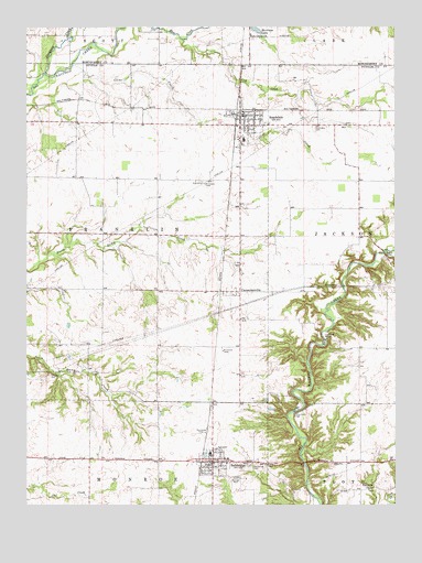
Roachdale, IN USGS Topographic Map
Click on map above to begin viewing in our Map Viewer.

This topographic map contains these locations and features:
Feature Name Type Latitude Longitude GNIS ID View Map
BainbridgePopulated PlaceN39.7612°W86.8120°430412View Map
Bainbridge CemeteryCemeteryN39.7607°W86.7989°430413View Map
Bainbridge Elementary SchoolSchoolN39.7639°W86.8128°447158View Map
Bainbridge Fire DepartmentBuildingN39.7617°W86.8184°2701383View Map
Bainbridge Half Mile Airport (historical)AirportN39.7731°W86.8103°449102View Map
Bainbridge Police DepartmentBuildingN39.7622°W86.8175°2758160View Map
Bainbridge Volunteer Fire DepartmentBuildingN39.7616°W86.8182°2625850View Map
CarpentersvillePopulated PlaceN39.8056°W86.8056°432163View Map
Cline CreekStreamN39.8653°W86.8589°432667View Map
Coffman CemeteryCemeteryN39.7906°W86.7676°432740View Map
Cornstalk CreekStreamN39.8623°W86.8686°432990View Map
Hartman CemeteryCemeteryN39.7844°W86.8672°435830View Map
Haw Creek ChurchChurchN39.8728°W86.7986°435896View Map
Higgins BridgeBridgeN39.8156°W86.7536°436134View Map
Lick CreekStreamN39.8712°W86.8217°437868View Map
Morrison LakeLakeN39.8743°W86.7970°439463View Map
Palestine ChurchChurchN39.7542°W86.7589°440842View Map
Pine Bluff BridgeBridgeN39.7928°W86.7739°441150View Map
RoachdalePopulated PlaceN39.8489°W86.8022°442122View Map
Roachdale CemeteryCemeteryN39.8482°W86.7783°442123View Map
Roachdale Fire DepartmentBuildingN39.8522°W86.8027°2626021View Map
Roachdale Police DepartmentBuildingN39.8522°W86.8021°2758036View Map
Rolling Stone BridgeBridgeN39.7748°W86.7842°442267View Map
Town of BainbridgeCivilN39.7614°W86.8113°2396584View Map
Town of RoachdaleCivilN39.8492°W86.8005°2396883View Map
Township of FranklinCivilN39.8213°W86.8462°453312View Map
Way West AirportAirportN39.7741°W86.7601°2676942View Map

Note: Coordinates in the location and feature list above are referenced to NAD83 datum.


Copyright (C) 2008-2025 Ryan Niemi / Sunset Dynamics ... All Rights Reserved