TopoQuest Logo
Do you find TopoQuest useful?
Help keep TopoQuest running and adding new maps/features by donating!
Bitcoin:  19c7KJd3qBynnjoSw5npx9KScwjBe4ifkT
Litecoin:  LXs6TkuXGGXo1vDsWCkWVdjQX94eUKd6ui
Home View Maps Find Maps Find Places Resources & Links


Sadieville, Kentucky Topographic Map

USGS Map Title: Sadieville, KY
USGS Map MRC: 38084D5
DRG (GeoTIFF) Download: o38084d5.tif


Neighboring USGS Topographic Map Quads:


  Lawrenceville, KY  
38084E6
 

  Mason, KY  
38084E5
 

  Berry, KY  
38084E4
 

  New Columbus, KY  
38084D6
 

  Sadieville, KY  
38084D5
 

  Breckinridge, KY  
38084D4
 

  Stamping Ground, KY  
38084C6
 

  Delaplain, KY  
38084C5
 

  Leesburg, KY  
38084C4


Map MRC Location:

N39°
W85°
N39°
W84°
H8 H7 H6 H5 H4 H3 H2 H1
G8 G7 G6 G5 G4 G3 G2 G1
F8 F7 F6 F5 F4 F3 F2 F1
E8 E7 E6 E5 E4 E3 E2 E1
D8 D7 D6 D5 D4 D3 D2 D1
C8 C7 C6 C5 C4 C3 C2 C1
B8 B7 B6 B5 B4 B3 B2 B1
A8 A7 A6 A5 A4 A3 A2 A1
N38°
W85°
N38°
W84°

Sadieville, KY USGS 1:24K Topographic Map Preview:
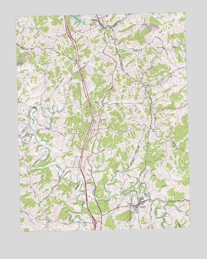
Sadieville, KY USGS Topographic Map
Click on map above to begin viewing in our Map Viewer.

This topographic map contains these locations and features:
Feature Name Type Latitude Longitude GNIS ID View Map
Arrowhead LakeReservoirN38.4921°W84.5255°2564152View Map
City of CorinthCivilN38.4997°W84.6029°2404131View Map
City of SadievilleCivilN38.3881°W84.5493°2405387View Map
CorinthPopulated PlaceN38.4967°W84.5641°490097View Map
Corinth Volunteer Fire DepartmentBuildingN38.4945°W84.5629°2636848View Map
Ecklers CemeteryCemeteryN38.4901°W84.5791°491549View Map
Elk Lick BranchStreamN38.4081°W84.5491°491665View Map
Gillespie CemeteryCemeteryN38.4059°W84.5244°492843View Map
Hall BranchStreamN38.3970°W84.5324°493570View Map
HintonPopulated PlaceN38.4573°W84.5294°508251View Map
K of P CemeteryCemeteryN38.3842°W84.5405°495562View Map
Leaning Oak (historical)Populated PlaceN38.4797°W84.5988°2742117View Map
Little Eagle CreekStreamN38.4028°W84.5786°496713View Map
Mallorys Mill Post Office (historical)Post OfficeN38.4326°W84.6244°2567403View Map
Mile RunStreamN38.4140°W84.5988°498182View Map
Nelson CemeteryCemeteryN38.4717°W84.5763°499253View Map
New Friendship ChurchChurchN38.4792°W84.5163°499318View Map
North Rays ForkStreamN38.4501°W84.5891°499586View Map
Old New CemeteryCemeteryN38.4978°W84.5172°499862View Map
PorterPopulated PlaceN38.3820°W84.6052°508858View Map
Rays ForkStreamN38.4312°W84.6122°501628View Map
Rays Fork ChurchChurchN38.4306°W84.6180°501629View Map
SadievillePopulated PlaceN38.3892°W84.5374°502554View Map
Sadieville Police DepartmentBuildingN38.3908°W84.5359°2767534View Map
Scott County Fire Department Station 2BuildingN38.3853°W84.5606°2637143View Map
South Rays ForkStreamN38.4501°W84.5891°503972View Map
Spoon BranchStreamN38.3892°W84.5436°504084View Map
StonewallPopulated PlaceN38.4392°W84.5647°509137View Map
Straight ForkStreamN38.3901°W84.5169°504560View Map
Wild Deer LakeReservoirN38.4758°W84.6199°2567466View Map
Zion Hill Church (historical)ChurchN38.4665°W84.6051°2567468View Map
Zion Hill Church CemeteryCemeteryN38.4667°W84.6052°507296View Map

Note: Coordinates in the location and feature list above are referenced to NAD83 datum.


Copyright (C) 2008-2024 Ryan Niemi / Sunset Dynamics ... All Rights Reserved