TopoQuest Logo
Do you find TopoQuest useful?
Help keep TopoQuest running and adding new maps/features by donating!
Bitcoin:  19c7KJd3qBynnjoSw5npx9KScwjBe4ifkT
Litecoin:  LXs6TkuXGGXo1vDsWCkWVdjQX94eUKd6ui
Home View Maps Find Maps Find Places Resources & Links


Saint Paul, Illinois Topographic Map

USGS Map Title: Saint Paul, IL
USGS Map MRC: 38088G8
DRG (GeoTIFF) Download: o38088g8.tif


Neighboring USGS Topographic Map Quads:


  Vandalia, IL  
38089H1
 

  Brownstown, IL  
38088H8
 

  Loogootee, IL  
38088H7
 

  Patoka, IL  
38089G1
 

  Saint Paul, IL  
38088G8
 

  Kinmundy, IL  
38088G7
 

  Fairman, IL  
38089F1
 

  Salem North, IL  
38088F8
 

  Omega, IL  
38088F7


Map MRC Location:

N39°
W89°
N39°
W88°
H8 H7 H6 H5 H4 H3 H2 H1
G8 G7 G6 G5 G4 G3 G2 G1
F8 F7 F6 F5 F4 F3 F2 F1
E8 E7 E6 E5 E4 E3 E2 E1
D8 D7 D6 D5 D4 D3 D2 D1
C8 C7 C6 C5 C4 C3 C2 C1
B8 B7 B6 B5 B4 B3 B2 B1
A8 A7 A6 A5 A4 A3 A2 A1
N38°
W89°
N38°
W88°

Saint Paul, IL USGS 1:24K Topographic Map Preview:
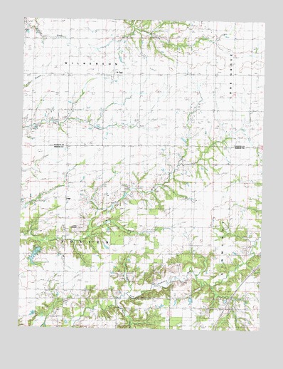
Saint Paul, IL USGS Topographic Map
Click on map above to begin viewing in our Map Viewer.

This topographic map contains these locations and features:
Feature Name Type Latitude Longitude GNIS ID View Map
Brasel School (historical)SchoolN38.8714°W88.9009°404803View Map
Bundy School (historical)SchoolN38.8414°W88.9584°405190View Map
Eastland CemeteryCemeteryN38.7514°W88.8828°407715View Map
Griffin AirportAirportN38.8006°W88.9985°2679018View Map
Interchange 127CrossingN38.7587°W88.8934°1821412View Map
Jones CemeteryCemeteryN38.7587°W88.9776°411209View Map
Jones CemeteryCemeteryN38.7917°W88.8914°1967137View Map
Jones School (historical)SchoolN38.7687°W88.9776°411221View Map
LesterPopulated PlaceN38.8025°W88.9764°422909View Map
Long BranchStreamN38.7900°W88.9639°412549View Map
Lowe MoundSummitN38.7909°W88.9698°412704View Map
Meadow Branch School (historical)SchoolN38.7553°W88.9012°413346View Map
North Fork CemeteryCemeteryN38.8078°W88.9464°1821429View Map
North Fork School (historical)SchoolN38.8056°W88.9489°414607View Map
Patoka Club LakeReservoirN38.7834°W88.9934°1691531View Map
Patoka Club Lake DamDamN38.7834°W88.9934°1691530View Map
Saint PaulPopulated PlaceN38.8528°W88.9534°417693View Map
Saint Paul Lutheran CemeteryCemeteryN38.8509°W88.9573°1802278View Map
Sandy BranchStreamN38.7642°W88.9442°417988View Map
Sandy Branch CemeteryCemeteryN38.7750°W88.9312°1821452View Map
Sandy Branch School (historical)SchoolN38.7759°W88.9398°417991View Map
Swift School (historical)SchoolN38.7912°W88.9064°419485View Map
Township of FosterCivilN38.7800°W88.9761°429016View Map
Township of WilbertonCivilN38.8672°W88.9755°429934View Map
Warren BranchStreamN38.7589°W88.9487°420532View Map

Note: Coordinates in the location and feature list above are referenced to NAD83 datum.


Copyright (C) 2008-2025 Ryan Niemi / Sunset Dynamics ... All Rights Reserved