TopoQuest Logo
Do you find TopoQuest useful?
Help keep TopoQuest running and adding new maps/features by donating!
Bitcoin:  19c7KJd3qBynnjoSw5npx9KScwjBe4ifkT
Litecoin:  LXs6TkuXGGXo1vDsWCkWVdjQX94eUKd6ui
Home View Maps Find Maps Find Places Resources & Links


Patoka, Illinois Topographic Map

USGS Map Title: Patoka, IL
USGS Map MRC: 38089G1
DRG (GeoTIFF) Download: o38089g1.tif


Neighboring USGS Topographic Map Quads:


  Hagarstown, IL  
38089H2
 

  Vandalia, IL  
38089H1
 

  Brownstown, IL  
38088H8
 

  Wildcat Lake, IL  
38089G2
 

  Patoka, IL  
38089G1
 

  Saint Paul, IL  
38088G8
 

  Boulder, IL  
38089F2
 

  Fairman, IL  
38089F1
 

  Salem North, IL  
38088F8


Map MRC Location:

N39°
W90°
N39°
W89°
H8 H7 H6 H5 H4 H3 H2 H1
G8 G7 G6 G5 G4 G3 G2 G1
F8 F7 F6 F5 F4 F3 F2 F1
E8 E7 E6 E5 E4 E3 E2 E1
D8 D7 D6 D5 D4 D3 D2 D1
C8 C7 C6 C5 C4 C3 C2 C1
B8 B7 B6 B5 B4 B3 B2 B1
A8 A7 A6 A5 A4 A3 A2 A1
N38°
W90°
N38°
W89°

Patoka, IL USGS 1:24K Topographic Map Preview:
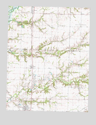
Patoka, IL USGS Topographic Map
Click on map above to begin viewing in our Map Viewer.

This topographic map contains these locations and features:
Feature Name Type Latitude Longitude GNIS ID View Map
AugsburgPopulated PlaceN38.8667°W89.0134°422423View Map
Augsburg CemeteryCemeteryN38.8687°W89.0139°1802257View Map
Caldwell CemeteryCemeteryN38.7525°W89.0020°405346View Map
Chance School (historical)SchoolN38.7503°W89.0151°1737036View Map
Conant CemeteryCemeteryN38.7887°W89.0062°1967130View Map
Crowder CemeteryCemeteryN38.8250°W89.0159°1966017View Map
Deer CreekStreamN38.7662°W89.1098°407059View Map
Doolen CemeteryCemeteryN38.8064°W89.0145°407314View Map
Doolen School (historical)SchoolN38.8017°W89.0142°1737040View Map
Farmer CemeteryCemeteryN38.8520°W89.1098°408279View Map
Finch CemeteryCemeteryN38.7725°W89.0720°408371View Map
Hatch CemeteryCemeteryN38.8014°W89.0589°409919View Map
Heckethorn CemeteryCemeteryN38.8506°W89.0587°410020View Map
Heckethorn School (historical)SchoolN38.8453°W89.0584°1736952View Map
Holt CemeteryCemeteryN38.7912°W89.0492°410417View Map
Illinois No Name Number 2040 DamDamN38.8517°W89.1034°1692300View Map
Illinois No Name Number 2040 ReservoirReservoirN38.8508°W89.1031°1692301View Map
Independence School (historical)SchoolN38.7798°W89.0581°1737061View Map
Kaskaskia School (historical)SchoolN38.8420°W89.1042°1736955View Map
Lee CemeteryCemeteryN38.8317°W89.0589°1965923View Map
Lee CreekStreamN38.8209°W89.0809°411910View Map
Lewis School (historical)SchoolN38.7509°W89.0498°1737066View Map
McConnell CemeteryCemeteryN38.8473°W89.0751°1965924View Map
Meador CemeteryCemeteryN38.7892°W89.0539°413342View Map
Mound School (historical)SchoolN38.8670°W89.0390°1736965View Map
PatokaPopulated PlaceN38.7553°W89.0953°415433View Map
Patoka CemeteryCemeteryN38.7573°W89.1001°1821432View Map
Patoka Christian ChurchChurchN38.7534°W89.0992°1983625View Map
Patoka Fire Protection District and Ambulance ServiceBuildingN38.7533°W89.0972°2640550View Map
Patoka Oil FieldOilfieldN38.7603°W89.1084°425316View Map
Patoka Post OfficePost OfficeN38.7536°W89.0964°2788621View Map
Patoka SchoolSchoolN38.7642°W89.0853°415435View Map
Plum BranchStreamN38.8298°W89.0153°415948View Map
Richview School (historical)SchoolN38.8017°W89.0584°1737091View Map
Riedle CemeteryCemeteryN38.8334°W89.0023°1725349View Map
Sadler School (historical)SchoolN38.8450°W89.0140°1736989View Map
ShobonierPopulated PlaceN38.8695°W89.0887°418447View Map
Shobonier Post OfficePost OfficeN38.8684°W89.0873°1773114View Map
The MoundSummitN38.8670°W89.0465°419632View Map
Thorp CemeteryCemeteryN38.8195°W89.1237°419692View Map
Tillman CemeteryCemeteryN38.8148°W89.0803°419716View Map
Township of KaskaskiaCivilN38.8640°W89.0852°429197View Map
Township of PatokaCivilN38.7798°W89.0846°429531View Map
VernonPopulated PlaceN38.8023°W89.0870°420268View Map
Vernon Post OfficePost OfficeN38.8027°W89.0878°2788308View Map
Village of PatokaCivilN38.7540°W89.0958°2399630View Map
Village of VernonCivilN38.8014°W89.0896°2400061View Map
White Haven School (historical)SchoolN38.7945°W89.1240°1737110View Map
Zion Church (historical)ChurchN38.7653°W89.0148°1737117View Map

Note: Coordinates in the location and feature list above are referenced to NAD83 datum.


Copyright (C) 2008-2024 Ryan Niemi / Sunset Dynamics ... All Rights Reserved