TopoQuest Logo
Do you find TopoQuest useful?
Help keep TopoQuest running and adding new maps/features by donating!
Bitcoin:  19c7KJd3qBynnjoSw5npx9KScwjBe4ifkT
Litecoin:  LXs6TkuXGGXo1vDsWCkWVdjQX94eUKd6ui
Home View Maps Find Maps Find Places Resources & Links


Sampsel, Missouri Topographic Map

USGS Map Title: Sampsel, MO
USGS Map MRC: 39093G6
DRG (GeoTIFF) Download: o39093g6.tif


Neighboring USGS Topographic Map Quads:


  Jamesport, MO  
39093H7
 

  Shearwood, MO  
39093H6
 

  Farmersville, MO  
39093H5
 

  Breckenridge, MO  
39093G7
 

  Sampsel, MO  
39093G6
 

  Chillicothe, MO  
39093G5
 

  Flat Creek, MO  
39093F7
 

  Utica West, MO  
39093F6
 

  Utica East, MO  
39093F5


Map MRC Location:

N40°
W94°
N40°
W93°
H8 H7 H6 H5 H4 H3 H2 H1
G8 G7 G6 G5 G4 G3 G2 G1
F8 F7 F6 F5 F4 F3 F2 F1
E8 E7 E6 E5 E4 E3 E2 E1
D8 D7 D6 D5 D4 D3 D2 D1
C8 C7 C6 C5 C4 C3 C2 C1
B8 B7 B6 B5 B4 B3 B2 B1
A8 A7 A6 A5 A4 A3 A2 A1
N39°
W94°
N39°
W93°

Sampsel, MO USGS 1:24K Topographic Map Preview:
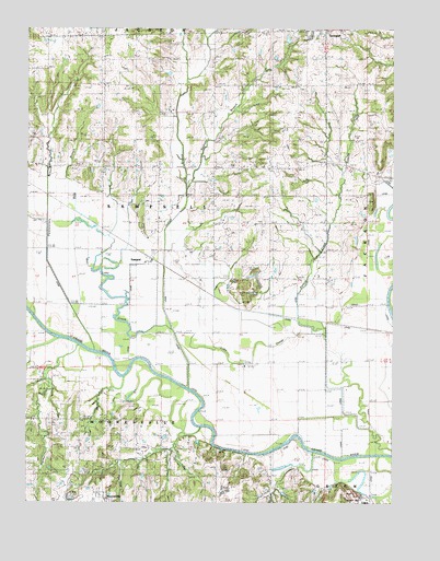
Sampsel, MO USGS Topographic Map
Click on map above to begin viewing in our Map Viewer.

This topographic map contains these locations and features:
Feature Name Type Latitude Longitude GNIS ID View Map
Bachelor BranchStreamN39.8325°W93.6944°713514View Map
Boucher School (historical)SchoolN39.8286°W93.7102°714557View Map
Brookshire School (historical)SchoolN39.8500°W93.7444°714752View Map
Brown School (historical)SchoolN39.8314°W93.6691°714786View Map
Clay Hill School (historical)SchoolN39.7725°W93.7491°715906View Map
Gibbs SchoolSchoolN39.8383°W93.6355°718423View Map
Hog BranchStreamN39.8225°W93.7263°719669View Map
Indian BranchStreamN39.7967°W93.7041°720102View Map
Kirk SchoolSchoolN39.8611°W93.7066°720646View Map
McVey Lake DamDamN39.8717°W93.6619°762489View Map
Moody School (historical)SchoolN39.7950°W93.7249°722556View Map
Mount Pleasant Baptist ChurchChurchN39.8598°W93.6576°2702425View Map
Mount Pleasant CemeteryCemeteryN39.8591°W93.6575°2702424View Map
Oak Ridge School (historical)SchoolN39.7714°W93.7194°723647View Map
Penitentiary BranchStreamN39.7925°W93.7322°724201View Map
Rawlie School (historical)SchoolN39.8600°W93.6660°730187View Map
SampselPopulated PlaceN39.8139°W93.7085°725991View Map
Shale HillSummitN39.7506°W93.6460°726261View Map
Sneed School (historical)SchoolN39.8092°W93.6733°726657View Map
SpringhillPopulated PlaceN39.8736°W93.6438°754141View Map
Straight Lake East DamDamN39.8683°W93.6652°762488View Map
Straight Lake West DamDamN39.8683°W93.6719°762487View Map
Township of SampselCivilN39.8250°W93.6995°766937View Map

Note: Coordinates in the location and feature list above are referenced to NAD83 datum.


Copyright (C) 2008-2024 Ryan Niemi / Sunset Dynamics ... All Rights Reserved