TopoQuest Logo
Do you find TopoQuest useful?
Help keep TopoQuest running and adding new maps/features by donating!
Bitcoin:  19c7KJd3qBynnjoSw5npx9KScwjBe4ifkT
Litecoin:  LXs6TkuXGGXo1vDsWCkWVdjQX94eUKd6ui
Home View Maps Find Maps Find Places Resources & Links


Shearwood, Missouri Topographic Map

USGS Map Title: Shearwood, MO
USGS Map MRC: 39093H6
DRG (GeoTIFF) Download: o39093h6.tif


Neighboring USGS Topographic Map Quads:


  Bancroft, MO  
40093A7
 

  Trenton West, MO  
40093A6
 

  Trenton East, MO  
40093A5
 

  Jamesport, MO  
39093H7
 

  Shearwood, MO  
39093H6
 

  Farmersville, MO  
39093H5
 

  Breckenridge, MO  
39093G7
 

  Sampsel, MO  
39093G6
 

  Chillicothe, MO  
39093G5


Map MRC Location:

N40°
W94°
N40°
W93°
H8 H7 H6 H5 H4 H3 H2 H1
G8 G7 G6 G5 G4 G3 G2 G1
F8 F7 F6 F5 F4 F3 F2 F1
E8 E7 E6 E5 E4 E3 E2 E1
D8 D7 D6 D5 D4 D3 D2 D1
C8 C7 C6 C5 C4 C3 C2 C1
B8 B7 B6 B5 B4 B3 B2 B1
A8 A7 A6 A5 A4 A3 A2 A1
N39°
W94°
N39°
W93°

Shearwood, MO USGS 1:24K Topographic Map Preview:
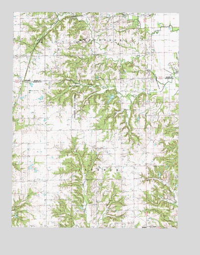
Shearwood, MO USGS Topographic Map
Click on map above to begin viewing in our Map Viewer.

This topographic map contains these locations and features:
Feature Name Type Latitude Longitude GNIS ID View Map
Blackburn School (historical)SchoolN39.9381°W93.7430°714323View Map
Center School (historical)SchoolN39.9783°W93.7069°715659View Map
Cisco (historical)LocaleN39.9470°W93.6313°740224View Map
Cisco Post OfficePost OfficeN39.9470°W93.6313°759646View Map
CoburnLocaleN39.9831°W93.7294°742968View Map
Coy CemeteryCemeteryN39.9620°W93.6599°1782201View Map
Davis CemeteryCemeteryN39.9600°W93.6710°1782202View Map
Dockery CemeteryCemeteryN39.9325°W93.6852°1782203View Map
Fair Lake DamDamN39.8983°W93.6269°762485View Map
Fender Farms LakeReservoirN39.9502°W93.7432°760563View Map
Fender Farms Lake Dam NorthDamN39.9583°W93.7371°762206View Map
Fender Farms Lake East DamDamN39.9517°W93.7269°762480View Map
Fender Farms Lake West DamDamN39.9517°W93.7436°760562View Map
Gee CemeteryCemeteryN39.9945°W93.6752°1782214View Map
Gees Creek CemeteryCemeteryN39.9850°W93.7452°1782204View Map
Gees SchoolSchoolN39.9797°W93.6755°718377View Map
GenovaPopulated PlaceN39.9058°W93.7047°740223View Map
Genova Post OfficePost OfficeN39.9061°W93.7047°759648View Map
Goodrich SchoolSchoolN39.9822°W93.6469°730106View Map
Haynes Lake DamDamN39.8817°W93.7469°761873View Map
Hickory CreekPopulated PlaceN39.9981°W93.6694°740928View Map
Hicks SchoolSchoolN39.8875°W93.7041°719502View Map
Hosman School (historical)SchoolN39.9397°W93.6313°719883View Map
Hutchinson CemeteryCemeteryN39.9222°W93.6838°1782205View Map
Kennedy CemeteryCemeteryN39.9311°W93.6319°1782206View Map
Lilly Grove CemeteryCemeteryN39.9222°W93.6885°1782207View Map
Lily Grove ChurchChurchN39.9214°W93.6891°721059View Map
Livingston CemeteryCemeteryN39.9667°W93.7338°1782208View Map
Matt Green CemeteryCemeteryN39.9872°W93.6874°1782209View Map
McDonnal Lake DamDamN39.8867°W93.6985°762486View Map
Mount Pleasant School (historical)SchoolN39.9795°W93.7438°722875View Map
Muddy Lane (historical)LocaleN39.9381°W93.7058°740423View Map
Pike LakeReservoirN39.9502°W93.6762°760856View Map
Pike Lake DamDamN39.9517°W93.6736°760855View Map
Pinkley SchoolSchoolN39.9103°W93.6585°724413View Map
Poosey State ForestForestN39.9478°W93.7047°742966View Map
Prothero School (historical)SchoolN39.9461°W93.6686°730182View Map
Reeter Lake DamDamN39.9233°W93.6402°762483View Map
Rinehart LakeReservoirN39.9065°W93.6393°761237View Map
Rinehart Lake DamDamN39.9050°W93.6402°761236View Map
Rosson CemeteryCemeteryN39.9339°W93.6530°1782210View Map
ShearwoodLocaleN39.9600°W93.7444°742967View Map
Shelburn ChurchChurchN39.9661°W93.6477°726305View Map
Shelburne CemeteryCemeteryN39.9653°W93.6488°1782211View Map
South Fork Gees CreekStreamN39.9581°W93.6349°726738View Map
Thompson CemeteryCemeteryN39.9683°W93.7185°1782212View Map
Township of JacksonCivilN39.8920°W93.6646°766932View Map
Township of JeffersonCivilN39.9957°W93.6927°766703View Map
Trager LakeReservoirN39.9385°W93.6556°761322View Map
Trager Lake West DamDamN39.9400°W93.6569°761321View Map
Ware School (historical)SchoolN39.8942°W93.7394°728348View Map
Woldridge CemeteryCemeteryN39.9695°W93.6663°1782213View Map

Note: Coordinates in the location and feature list above are referenced to NAD83 datum.


Copyright (C) 2008-2025 Ryan Niemi / Sunset Dynamics ... All Rights Reserved