TopoQuest Logo
Do you find TopoQuest useful?
Help keep TopoQuest running and adding new maps/features by donating!
Bitcoin:  19c7KJd3qBynnjoSw5npx9KScwjBe4ifkT
Litecoin:  LXs6TkuXGGXo1vDsWCkWVdjQX94eUKd6ui
Home View Maps Find Maps Find Places Resources & Links


Bippus, Indiana Topographic Map

USGS Map Title: Bippus, IN
USGS Map MRC: 40085H5
DRG (GeoTIFF) Download: o40085h5.tif


Neighboring USGS Topographic Map Quads:


  South Whitley West, IN  
41085A6
 

  South Whitley East, IN  
41085A5
 

  Laud, IN  
41085A4
 

  Servia, IN  
40085H6
 

  Bippus, IN  
40085H5
 

  Huntington, IN  
40085H4
 

  Lagro, IN  
40085G6
 

  Andrews, IN  
40085G5
 

  Majenica, IN  
40085G4


Map MRC Location:

N41°
W86°
N41°
W85°
H8 H7 H6 H5 H4 H3 H2 H1
G8 G7 G6 G5 G4 G3 G2 G1
F8 F7 F6 F5 F4 F3 F2 F1
E8 E7 E6 E5 E4 E3 E2 E1
D8 D7 D6 D5 D4 D3 D2 D1
C8 C7 C6 C5 C4 C3 C2 C1
B8 B7 B6 B5 B4 B3 B2 B1
A8 A7 A6 A5 A4 A3 A2 A1
N40°
W86°
N40°
W85°

Bippus, IN USGS 1:24K Topographic Map Preview:
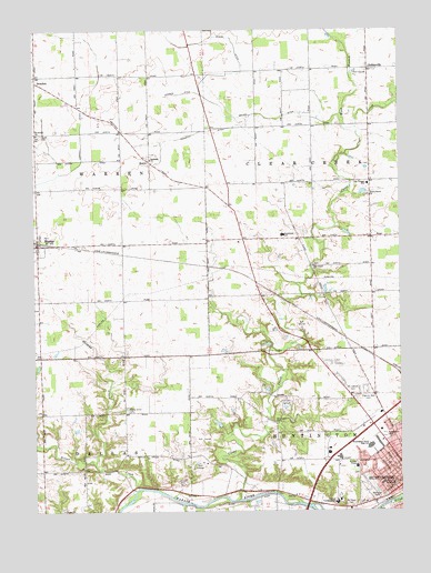
Bippus, IN USGS Topographic Map
Click on map above to begin viewing in our Map Viewer.

This topographic map contains these locations and features:
Feature Name Type Latitude Longitude GNIS ID View Map
Beck Private AirportAirportN40.9602°W85.5595°2677034View Map
Beech Grove ChurchChurchN40.9573°W85.5103°430730View Map
Bethesda ChurchChurchN40.9667°W85.5850°430969View Map
BippusPopulated PlaceN40.9442°W85.6239°431097View Map
Bippus West Fire DepartmentBuildingN40.9474°W85.6229°2625572View Map
BrackenPopulated PlaceN40.9867°W85.6239°431433View Map
Brown DitchCanalN40.9770°W85.5433°431615View Map
Carroll DitchCanalN40.9728°W85.6086°432176View Map
City of HuntingtonCivilN40.8820°W85.5054°2394452View Map
Clear CreekStreamN40.8781°W85.5555°432613View Map
Clear Creek ChurchChurchN40.9389°W85.5297°432617View Map
Deemer DitchCanalN40.9834°W85.5747°433410View Map
Funk CemeteryCemeteryN40.9728°W85.6222°434904View Map
GoblesvillePopulated PlaceN40.9900°W85.5103°435145View Map
Huntington North High SchoolSchoolN40.8925°W85.5111°436637View Map
Kriegbaum FieldParkN40.8948°W85.5055°437458View Map
Little RiverStreamN40.8767°W85.5314°438131View Map
MakinPopulated PlaceN40.9659°W85.5855°438495View Map
Maple Grove CemeteryCemeteryN40.9011°W85.5933°438553View Map
Memorial ParkParkN40.8789°W85.5089°438999View Map
Mount Calvary CemeteryCemeteryN40.9059°W85.5166°439527View Map
Mount Hope CemeteryCemeteryN40.8773°W85.5178°439582View Map
Myers DitchCanalN40.9939°W85.5555°439916View Map
Nieman CreekStreamN40.8873°W85.6047°440171View Map
Northwest Elementary SchoolSchoolN40.9473°W85.5400°440344View Map
Norwood Health and Rehabilitation CenterBuildingN40.8843°W85.5598°2660501View Map
Pilgrims Rest CemeteryCemeteryN40.9042°W85.5150°441142View Map
Saint Felix FriaryChurchN40.8870°W85.5150°442531View Map
Saint Peter Lutheran SchoolSchoolN40.8823°W85.5025°442821View Map
Saint Peters ChurchChurchN40.9731°W85.6239°442816View Map
Silver CreekStreamN40.8812°W85.5897°443495View Map
The Village SchoolSchoolN40.9600°W85.5111°444680View Map
Township of Clear CreekCivilN40.9604°W85.5089°453221View Map
Township of WarrenCivilN40.9590°W85.6046°453975View Map
Verdrick DitchCanalN40.9739°W85.5669°445246View Map
Victory Training InstituteSchoolN40.8781°W85.5222°445281View Map
West Branch Clear CreekStreamN40.9748°W85.5144°445719View Map
WVSH-FM (Huntington)TowerN40.8923°W85.5105°449012View Map

Note: Coordinates in the location and feature list above are referenced to NAD83 datum.


Copyright (C) 2008-2024 Ryan Niemi / Sunset Dynamics ... All Rights Reserved