TopoQuest Logo
Do you find TopoQuest useful?
Help keep TopoQuest running and adding new maps/features by donating!
Bitcoin:  19c7KJd3qBynnjoSw5npx9KScwjBe4ifkT
Litecoin:  LXs6TkuXGGXo1vDsWCkWVdjQX94eUKd6ui
Home View Maps Find Maps Find Places Resources & Links


Majenica, Indiana Topographic Map

USGS Map Title: Majenica, IN
USGS Map MRC: 40085G4
DRG (GeoTIFF) Download: o40085g4.tif


Neighboring USGS Topographic Map Quads:


  Bippus, IN  
40085H5
 

  Huntington, IN  
40085H4
 

  Zanesville, IN  
40085H3
 

  Andrews, IN  
40085G5
 

  Majenica, IN  
40085G4
 

  Markle, IN  
40085G3
 

  Mount Etna, IN  
40085F5
 

  Warren, IN  
40085F4
 

  Liberty Center, IN  
40085F3


Map MRC Location:

N41°
W86°
N41°
W85°
H8 H7 H6 H5 H4 H3 H2 H1
G8 G7 G6 G5 G4 G3 G2 G1
F8 F7 F6 F5 F4 F3 F2 F1
E8 E7 E6 E5 E4 E3 E2 E1
D8 D7 D6 D5 D4 D3 D2 D1
C8 C7 C6 C5 C4 C3 C2 C1
B8 B7 B6 B5 B4 B3 B2 B1
A8 A7 A6 A5 A4 A3 A2 A1
N40°
W86°
N40°
W85°

Majenica, IN USGS 1:24K Topographic Map Preview:
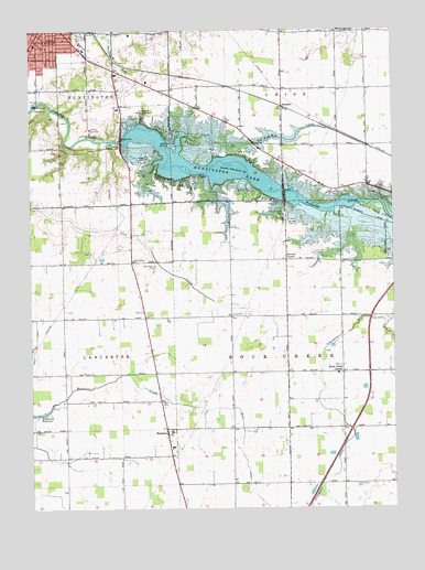
Majenica, IN USGS Topographic Map
Click on map above to begin viewing in our Map Viewer.

This topographic map contains these locations and features:
Feature Name Type Latitude Longitude GNIS ID View Map
Arrowhead Fishing SiteParkN40.8473°W85.4653°449475View Map
Barnes CemeteryCemeteryN40.8245°W85.4111°430502View Map
Bowlin AirportAirportN40.8366°W85.4882°449203View Map
Browns CornerPopulated PlaceN40.8150°W85.4116°449624View Map
Elkenberry DitchCanalN40.7823°W85.4000°434078View Map
Ellis DitchCanalN40.7714°W85.4275°434109View Map
Hier ParkParkN40.8739°W85.4819°436126View Map
Huntington CountyCivilN40.8292°W85.4882°450361View Map
Huntington County RescueBuildingN40.8730°W85.4849°2719310View Map
Huntington LakeReservoirN40.8427°W85.4536°436636View Map
Huntington Lake DamDamN40.8462°W85.4686°448678View Map
Huntington Municipal AirportAirportN40.8546°W85.4675°449202View Map
Kil-So-Quah State Recreation AreaParkN40.8439°W85.4411°437292View Map
Little Turtle State Recreation AreaParkN40.8337°W85.4439°438164View Map
Loon Creek CemeteryCemeteryN40.8134°W85.4566°438302View Map
MajenicaPopulated PlaceN40.7700°W85.4533°438489View Map
Markle State Recreation AreaParkN40.8284°W85.3766°438625View Map
Rees CemeteryCemeteryN40.7780°W85.4551°441869View Map
Rock Creek CenterPopulated PlaceN40.7856°W85.3925°442197View Map
SimpsonPopulated PlaceN40.8550°W85.4130°443528View Map
Star of Hope CemeteryCemeteryN40.8273°W85.4125°444074View Map
Tah Kum Wah CreekStreamN40.8470°W85.4419°444547View Map
Township of Rock CreekCivilN40.7862°W85.3929°453810View Map
Township of UnionCivilN40.8738°W85.3937°453919View Map
Wabash ChurchChurchN40.8253°W85.4122°445330View Map
Yankeetown CemeteryCemeteryN40.7563°W85.3889°446364View Map

Note: Coordinates in the location and feature list above are referenced to NAD83 datum.


Copyright (C) 2008-2024 Ryan Niemi / Sunset Dynamics ... All Rights Reserved