TopoQuest Logo
Do you find TopoQuest useful?
Help keep TopoQuest running and adding new maps/features by donating!
Bitcoin:  19c7KJd3qBynnjoSw5npx9KScwjBe4ifkT
Litecoin:  LXs6TkuXGGXo1vDsWCkWVdjQX94eUKd6ui
Home View Maps Find Maps Find Places Resources & Links


Sauk Centre, Minnesota Topographic Map

USGS Map Title: Sauk Centre, MN
USGS Map MRC: 45094F8
DRG (GeoTIFF) Download: o45094f8.tif


Neighboring USGS Topographic Map Quads:


  West Union, MN  
45095G1
 

  Sauk Lake, MN  
45094G8
 

  Ward Springs, MN  
45094G7
 

  Raymond Lake, MN  
45095F1
 

  Sauk Centre, MN  
45094F8
 

  Melrose, MN  
45094F7
 

  Padua, MN  
45095E1
 

  Elrosa, MN  
45094E8
 

  Greenwald, MN  
45094E7


Map MRC Location:

N46°
W95°
N46°
W94°
H8 H7 H6 H5 H4 H3 H2 H1
G8 G7 G6 G5 G4 G3 G2 G1
F8 F7 F6 F5 F4 F3 F2 F1
E8 E7 E6 E5 E4 E3 E2 E1
D8 D7 D6 D5 D4 D3 D2 D1
C8 C7 C6 C5 C4 C3 C2 C1
B8 B7 B6 B5 B4 B3 B2 B1
A8 A7 A6 A5 A4 A3 A2 A1
N45°
W95°
N45°
W94°

Sauk Centre, MN USGS 1:24K Topographic Map Preview:
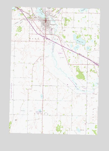
Sauk Centre, MN USGS Topographic Map
Click on map above to begin viewing in our Map Viewer.

This topographic map contains these locations and features:
Feature Name Type Latitude Longitude GNIS ID View Map
Assembly of God ChurchChurchN45.7386°W94.9544°2068364View Map
Bohemian CemeteryCemeteryN45.6473°W94.9844°640340View Map
Boyack Mobile Home ParkPopulated PlaceN45.7494°W94.9389°2068345View Map
Boyhood Home of Sinclair LewisBuildingN45.7375°W94.9569°2068351View Map
Browns ParkParkN45.7342°W94.9442°2068375View Map
Bryant Public LibraryBuildingN45.7350°W94.9517°2068348View Map
Calvary CemeteryCemeteryN45.7389°W94.9287°640774View Map
Church of the Good SamaritanChurchN45.7336°W94.9511°2068363View Map
City of Sauk CentreCivilN45.7373°W94.9525°2396541View Map
Conservation ParkParkN45.7408°W94.9492°2068374View Map
Faith Baptist ChurchChurchN45.7464°W94.9444°2068365View Map
First Lutheran ChurchChurchN45.7369°W94.9550°2068359View Map
First United ChurchChurchN45.7347°W94.9536°2068362View Map
Greenwood CemeteryCemeteryN45.7372°W94.9290°644461View Map
Hoboken CreekStreamN45.7430°W94.9631°645045View Map
Holy Family SchoolSchoolN45.7375°W94.9475°2068371View Map
I-94 RacewayLocaleN45.7167°W94.9486°2068349View Map
Interchange 124CrossingN45.7458°W94.9864°2068404View Map
Interchange 127CrossingN45.7208°W94.9517°2068403View Map
Interchange 131CrossingN45.6956°W94.8806°2068402View Map
Isabelle LakeLakeN45.6291°W94.9016°645467View Map
Jaycees ParkParkN45.7444°W94.9506°2068373View Map
Kingdom Hall of Jehovah's WitnessesChurchN45.7386°W94.9722°2068366View Map
Lakeview Medical ClinicHospitalN45.7458°W94.9553°2068369View Map
Main Street Historical MarkerParkN45.7225°W94.9519°2068378View Map
McCormic LakeLakeN45.7185°W94.9038°647668View Map
Moliter LakeSwampN45.6380°W94.9931°648016View Map
Oak Lane Dairy FarmLocaleN45.6281°W94.9983°2635896View Map
Oakland CemeteryCemeteryN45.7276°W94.9277°648871View Map
Our Lady of Angels ChurchChurchN45.7319°W94.9469°2068361View Map
Saint Anthony's ChurchChurchN45.7417°W94.9667°2068367View Map
Saint Paul's Catholic ChurchChurchN45.7375°W94.9489°2068357View Map
Saint Pauls CemeteryCemeteryN45.7411°W94.9287°650989View Map
Sauk CentrePopulated PlaceN45.7375°W94.9525°651233View Map
Sauk Centre (historical)LocaleN45.7333°W94.9542°2068347View Map
Sauk Centre Ambulance ServiceBuildingN45.7215°W94.9499°2721209View Map
Sauk Centre Centra Care HospitalHospitalN45.7460°W94.9556°2068370View Map
Sauk Centre City HallBuildingN45.7369°W94.9506°2068355View Map
Sauk Centre Fire DepartmentBuildingN45.7362°W94.9541°2068352View Map
Sauk Centre Golf ClubLocaleN45.7494°W94.9556°2068354View Map
Sauk Centre Municipal AirportAirportN45.7066°W94.9334°660410View Map
Sauk Centre Police DepartmentBuildingN45.7361°W94.9538°2068353View Map
Sauk Centre Post OfficePost OfficeN45.7356°W94.9519°2068356View Map
Sauk Centre Public SchoolsSchoolN45.7292°W94.9428°2068372View Map
Sauk River DamDamN45.7405°W94.9520°1776759View Map
School Number 1981SchoolN45.6583°W94.9781°651456View Map
Sinclair Lewis Historical MarkerParkN45.7375°W94.9569°2068350View Map
Sinclair Lewis Interpretive CenterBuildingN45.7222°W94.9528°2068346View Map
Sinclair Lewis ParkParkN45.7402°W94.9597°652083View Map
Stearns County FairgroundsLocaleN45.7250°W94.9444°2068368View Map
Township of GettyCivilN45.6291°W94.9535°664264View Map
Township of Sauk CentreCivilN45.6953°W94.9537°665558View Map
United Methodist ChurchChurchN45.7344°W94.9550°2068360View Map
Zion Lutheran ChurchChurchN45.7367°W94.9567°2068358View Map

Note: Coordinates in the location and feature list above are referenced to NAD83 datum.


Copyright (C) 2008-2024 Ryan Niemi / Sunset Dynamics ... All Rights Reserved