TopoQuest Logo
Do you find TopoQuest useful?
Help keep TopoQuest running and adding new maps/features by donating!
Bitcoin:  19c7KJd3qBynnjoSw5npx9KScwjBe4ifkT
Litecoin:  LXs6TkuXGGXo1vDsWCkWVdjQX94eUKd6ui
Home View Maps Find Maps Find Places Resources & Links


Scopus, Missouri Topographic Map

USGS Map Title: Scopus, MO
USGS Map MRC: 37089D8
DRG (GeoTIFF) Download: o37089d8.tif


Neighboring USGS Topographic Map Quads:


  Patton, MO  
37090E1
 

  Sedgewickville, MO  
37089E8
 

  Friedheim, MO  
37089E7
 

  Hurricane, MO  
37090D1
 

  Scopus, MO  
37089D8
 

  Millersville, MO  
37089D7
 

  Glenallen, MO  
37090C1
 

  Marble Hill, MO  
37089C8
 

  Burfordville, MO  
37089C7


Map MRC Location:

N38°
W90°
N38°
W89°
H8 H7 H6 H5 H4 H3 H2 H1
G8 G7 G6 G5 G4 G3 G2 G1
F8 F7 F6 F5 F4 F3 F2 F1
E8 E7 E6 E5 E4 E3 E2 E1
D8 D7 D6 D5 D4 D3 D2 D1
C8 C7 C6 C5 C4 C3 C2 C1
B8 B7 B6 B5 B4 B3 B2 B1
A8 A7 A6 A5 A4 A3 A2 A1
N37°
W90°
N37°
W89°

Scopus, MO USGS 1:24K Topographic Map Preview:
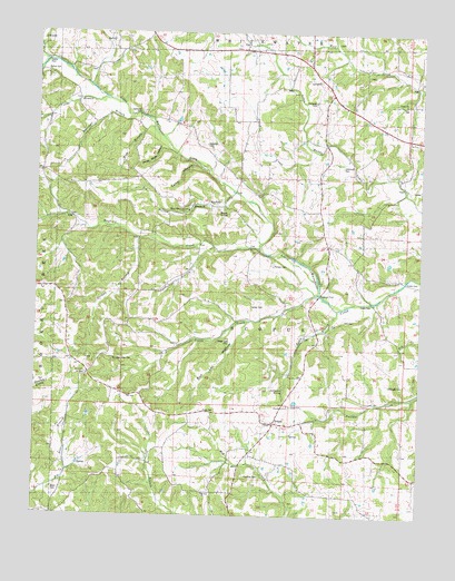
Scopus, MO USGS Topographic Map
Click on map above to begin viewing in our Map Viewer.

This topographic map contains these locations and features:
Feature Name Type Latitude Longitude GNIS ID View Map
Angle FordLocaleN37.4306°W89.8912°743345View Map
Baker BranchStreamN37.4295°W89.9007°713557View Map
Bess CemeteryCemeteryN37.3809°W89.9929°714004View Map
Big Hollow BranchStreamN37.4584°W89.9368°719718View Map
Bollinger BranchStreamN37.4778°W89.9701°714500View Map
Bollinger FordLocaleN37.4326°W89.9079°743344View Map
Bollinger School (historical)SchoolN37.4239°W89.9057°714504View Map
Buck KnobSummitN37.4534°W89.9412°738599View Map
Bull Lot HollowValleyN37.4256°W89.9301°738596View Map
Camp HollowValleyN37.4648°W89.9462°738601View Map
Cedar Branch School (historical)SchoolN37.3887°W89.9598°715574View Map
Cheek CreekStreamN37.4689°W89.9098°715754View Map
Chostner CemeteryCemeteryN37.3859°W89.9265°743339View Map
Church of ChristChurchN37.4037°W89.9176°743340View Map
Coles CemeteryCemeteryN37.4023°W89.9448°743338View Map
Coles School (historical)ChurchN37.4017°W89.9437°716115View Map
Cook CemeteryCemeteryN37.4034°W89.9157°729995View Map
Cooks BranchStreamN37.4442°W89.9418°738598View Map
Dalton CemeteryCemeteryN37.4898°W89.9970°743350View Map
Dalton FordLocaleN37.4926°W89.9971°743349View Map
Fish BranchStreamN37.4756°W89.9618°717935View Map
German BranchStreamN37.4462°W89.9662°718410View Map
Holt CemeteryCemeteryN37.4259°W89.8998°743343View Map
James CemeteryCemeteryN37.4292°W89.9298°743342View Map
James CreekStreamN37.4323°W89.9076°720247View Map
James School (historical)SchoolN37.4212°W89.9570°720249View Map
Judge Long CemeteryCemeteryN37.4209°W89.9373°743341View Map
Kinder FordLocaleN37.4359°W89.8801°743346View Map
Limbaugh CemeteryCemeteryN37.4087°W89.8790°721065View Map
Limbaugh School (historical)SchoolN37.4059°W89.8893°730524View Map
Little Whitewater ChurchChurchN37.4542°W89.9509°743352View Map
Lona Lou LakeReservoirN37.4951°W89.8901°765157View Map
Lona Lou Lake DamDamN37.4951°W89.8901°765156View Map
MayfieldPopulated PlaceN37.4542°W89.9493°722011View Map
Mayfield CreekStreamN37.4451°W89.9273°750974View Map
Mount Zion ChurchChurchN37.3806°W89.9440°722951View Map
Mountain View CemeteryCemeteryN37.4159°W89.9740°743337View Map
North County Fire Protection District Station 1BuildingN37.4061°W89.9714°2620849View Map
Otter Slide HollowValleyN37.4684°W89.9543°738600View Map
Pulliam CemeteryCemeteryN37.4398°W89.9226°724989View Map
ScopusPopulated PlaceN37.3989°W89.9207°726206View Map
Seabaugh CemeteryCemeteryN37.4823°W89.9101°743347View Map
Seabaugh CemeteryCemeteryN37.4712°W89.9454°743348View Map
Seabaugh FordLocaleN37.4789°W89.9673°743351View Map
Seabaugh School (historical)SchoolN37.4773°W89.9679°726166View Map
Sedgewickville Fire Protection District Station 2BuildingN37.4535°W89.9520°2620890View Map
Smith SchoolSchoolN37.4798°W89.8993°726625View Map
Stillhouse SpringSpringN37.4084°W89.9190°738597View Map
Township of ScopusCivilN37.4329°W89.9279°766325View Map
Trinity Church (historical)ChurchN37.4818°W89.8807°727786View Map
Yantz BranchStreamN37.4823°W89.9779°752995View Map

Note: Coordinates in the location and feature list above are referenced to NAD83 datum.


Copyright (C) 2008-2024 Ryan Niemi / Sunset Dynamics ... All Rights Reserved