TopoQuest Logo
Do you find TopoQuest useful?
Help keep TopoQuest running and adding new maps/features by donating!
Bitcoin:  19c7KJd3qBynnjoSw5npx9KScwjBe4ifkT
Litecoin:  LXs6TkuXGGXo1vDsWCkWVdjQX94eUKd6ui
Home View Maps Find Maps Find Places Resources & Links


Millersville, Missouri Topographic Map

USGS Map Title: Millersville, MO
USGS Map MRC: 37089D7
DRG (GeoTIFF) Download: o37089d7.tif


Neighboring USGS Topographic Map Quads:


  Sedgewickville, MO  
37089E8
 

  Friedheim, MO  
37089E7
 

  Oak Ridge, MO  
37089E6
 

  Scopus, MO  
37089D8
 

  Millersville, MO  
37089D7
 

  Jackson, MO  
37089D6
 

  Marble Hill, MO  
37089C8
 

  Burfordville, MO  
37089C7
 

  Gordonville, MO  
37089C6


Map MRC Location:

N38°
W90°
N38°
W89°
H8 H7 H6 H5 H4 H3 H2 H1
G8 G7 G6 G5 G4 G3 G2 G1
F8 F7 F6 F5 F4 F3 F2 F1
E8 E7 E6 E5 E4 E3 E2 E1
D8 D7 D6 D5 D4 D3 D2 D1
C8 C7 C6 C5 C4 C3 C2 C1
B8 B7 B6 B5 B4 B3 B2 B1
A8 A7 A6 A5 A4 A3 A2 A1
N37°
W90°
N37°
W89°

Millersville, MO USGS 1:24K Topographic Map Preview:
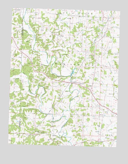
Millersville, MO USGS Topographic Map
Click on map above to begin viewing in our Map Viewer.

This topographic map contains these locations and features:
Feature Name Type Latitude Longitude GNIS ID View Map
Ates CemeteryCemeteryN37.4570°W89.8701°743326View Map
Baker CemeteryCemeteryN37.4500°W89.8218°743323View Map
Big Spring School (historical)SchoolN37.4084°W89.7654°714231View Map
Byrd CemeteryCemeteryN37.4717°W89.7593°743319View Map
Calvary CemeteryCemeteryN37.3970°W89.8265°743334View Map
Caney ForkStreamN37.4395°W89.8179°715358View Map
Caney Fork ChurchChurchN37.4953°W89.8220°715359View Map
Cave HillSummitN37.3834°W89.8223°738594View Map
Cedar LakeReservoirN37.4427°W89.8030°738593View Map
Cedar Lake DamDamN37.4395°W89.8045°763564View Map
Crawford CreekStreamN37.4353°W89.7554°716474View Map
Criddle CemeteryCemeteryN37.3800°W89.8298°743335View Map
Deck CemeteryCemeteryN37.3909°W89.7993°743333View Map
Devils BackboneRidgeN37.4589°W89.8115°738592View Map
Dry CreekStreamN37.4247°W89.8528°738542View Map
Estes CemeteryCemeteryN37.4695°W89.8545°743321View Map
Fairview ChurchChurchN37.3987°W89.8532°717777View Map
Fulbright SchoolSchoolN37.4909°W89.7745°718280View Map
Gladish CemeteryCemeteryN37.4045°W89.7706°743330View Map
Gravel Hill ChurchChurchN37.4606°W89.7623°718738View Map
Hartle CemeteryCemeteryN37.4348°W89.8634°719179View Map
Hartle FordPopulated PlaceN37.4331°W89.8532°740909View Map
Hartle School (historical)SchoolN37.4187°W89.8665°719180View Map
Haynes ChapelChurchN37.3873°W89.8398°743336View Map
Herzinger CemeteryCemeteryN37.3939°W89.7695°743331View Map
Kurre CemeteryCemeteryN37.4820°W89.8212°743316View Map
KurrevillePopulated PlaceN37.4753°W89.8215°720706View Map
Link SchoolSchoolN37.3948°W89.7895°721119View Map
Little Muddy CreekStreamN37.4403°W89.8623°721279View Map
Little Whitewater CreekStreamN37.4017°W89.8134°755555View Map
Mayfield CemeteryCemeteryN37.4714°W89.7962°743320View Map
Miller CemeteryCemeteryN37.4248°W89.8073°743329View Map
MillersvillePopulated PlaceN37.4328°W89.7995°722401View Map
Millersville ChurchChurchN37.4587°W89.7807°743322View Map
Millersville Post OfficePost OfficeN37.4323°W89.7990°2782804View Map
Millersville SchoolSchoolN37.4306°W89.7809°743327View Map
Neiswanger School (historical)SchoolN37.4520°W89.8537°723161View Map
Niswonger ChurchChurchN37.4495°W89.8507°743325View Map
Number 815 DamDamN37.4167°W89.8301°763900View Map
Old Caney Fork CemeteryCemeteryN37.4914°W89.8065°743314View Map
Old Niswonger CemeteryCemeteryN37.4478°W89.8362°743324View Map
Old Salem CemeteryCemeteryN37.4615°W89.8063°2681398View Map
Old Salem ChurchChurchN37.4614°W89.8084°723784View Map
Old Salem SchoolSchoolN37.4653°W89.7940°723786View Map
Panther CreekStreamN37.4062°W89.8398°723987View Map
Prince AirportAirportN37.4394°W89.7599°2679362View Map
Reynolds FordPopulated PlaceN37.4278°W89.8362°741194View Map
Riehn CemeteryCemeteryN37.4806°W89.8415°743317View Map
Rieman SchoolSchoolN37.4248°W89.8179°725300View Map
Sandy BranchStreamN37.4614°W89.8120°738591View Map
Schmidt CemeteryCemeteryN37.4914°W89.8451°743315View Map
Schroder BranchStreamN37.3784°W89.8057°738595View Map
Schroder SchoolSchoolN37.3878°W89.8362°726121View Map
Slinkerd CemeteryCemeteryN37.3889°W89.7704°743332View Map
Snyder CemeteryCemeteryN37.4359°W89.7770°726678View Map
Township of WhitewaterCivilN37.4471°W89.8096°766404View Map
Wilkinson CemeteryCemeteryN37.4237°W89.7606°743328View Map
Wise CemeteryCemeteryN37.4753°W89.8309°743318View Map
Wolf CreekStreamN37.4745°W89.8487°729045View Map

Note: Coordinates in the location and feature list above are referenced to NAD83 datum.


Copyright (C) 2008-2024 Ryan Niemi / Sunset Dynamics ... All Rights Reserved